Navaho Peak, Falls Creek, Ingalls Creek, Fourth Creek, Hardscrabble Creek, Standup Creek, Earl Peak, Bean Peak — Jun. 21, 2020

![]() 15 people found this report helpful
15 people found this report helpful
Started at Stafford Creek Trailhead, went north to the Old County Line Trail, following it up to Navaho. Beautiful wildflowers (true for the entire trip), trail in great condition all the way to Navaho Peak. Came off Navaho on the east side following the lightly trod boot path and rejoined the Old Country Line Trail. The path was relatively easy to follow, some moderate snow that was easy to avoid.
Followed Old Country Line Trail for just a little before turning north onto Falls Creek Trail. There was about a 1/4 mile of snow that was slow but easily traversed even without microspikes. The trail wasn't obvious in many spots but I had little difficulty getting through. Use of a GPS device helped guide me when I got off-trail. There's an occasional flagging or cairn to help guide. The only serious challenge faced was the second to last crossing of Falls Creek when the trail suddenly, and unexpectedly ascended a cliff face before continuing back downhill.
Falls Creek Trail finally crosses Ingalls Creek with no bridge or down tree to assist. The creek was fast flowing, but no more than 20" at the deepest. I was able to ford without poles or other assistance. The trail creek crossing is not marked and I emerged right in the middle of a group of campers who were both puzzled and shocked to see me emerge wet.
I followed Ingalls Creek Trail going west. There are many downed trees that substantially slowed progress, but the trail is otherwise obvious. I turned south on Fourth Creek trail (the turnoff was helpfully marked). Crossing Ingalls Creek would have been a little more difficult due to faster running water. Fortunately, there was a downed log a few hundred feet west of the path crossing that I was able to shimmy across without getting wet.
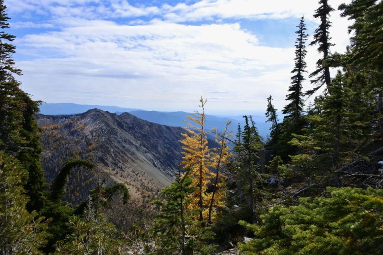
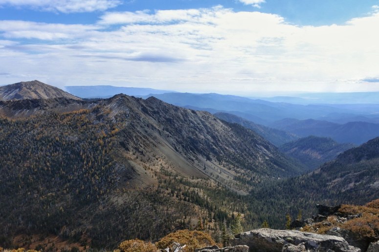
Fourth Creek is a gorgeous trail and in remarkable condition given that it doesn't look like it gets much traffic. Great views, great flowers, and few obstacles other than minor water on the trail. I followed the trail before turning hard east onto Hardscrabble Creek Trail. The ascent up to Bean is straight forward and also affords great views of Stuart and the other Enchantment peaks. Expect a Class 2 scramble up Bean Peak.
Coming down Bean was more challenging than going up (as always) - arguably a Class 3 scramble. I dropped down the south side (though several people took a more eastern approach) as it seemed a bit less dangerous, and cut across the face to rejoin the ridge heading South East. I followed the ridge to Earl Peak. While the traverse wasn't particularly bad, it was tough to do after a long day and proved very slow going. I also wouldn't want to do it with a full backpack.
I came off of Earl Peak to the south, then cut east on Bean Creek Trail and finally taking Standup Trail south. Standup Trail had a significant number of downed trees and hops back and forth across the creek several times, also slowing progress but was otherwise easy to follow all the way to FS9703, where I turned east to get back to Stafford Trailhead.
Beverly Turnpike, Fourth Creek, Hardscrabble Creek — Nov. 3, 2019

![]() 3 people found this report helpful
3 people found this report helpful
On Sunday four friends and I headed out for one last larch march of the season. We were pleasantly surprised by Beverly Turnpike, which didn't have too many larches once we got out of the valley floor, but did have lovely views of the drainage, as well as Iron Peak and Teanaway Peak.
The trail was lonely. Aside from our group, we only saw two mountain bikers all day.
At the junction of the Fourth Creek Trail, we headed up to the saddle east of Bills Peak, and then up Hardscrabble to a (limited) view of Stuart and the Ingalls Creek drainage. This was good scramble practice: we had a range of climbing abilities, from someone who climbs nearly every week, to those of us who haven't done it in years (me), and with some coaching, all of us made it to the viewpoint.
Because there was a little concern about the descent, we talked about how we'd head downhill, then agreed upon a formation and order. The most experienced one of us picked the route down, and she did a great job leading us down.
The hike out was uneventful, but because it was daylight savings, we got to enjoy golden hour on trail and on the drive back, which was lovely. It accented the larches visible from the trail, and we even found a birch tree that was strikingly gold right at the end of the hike.
Fourth Creek — Jul. 20, 2019
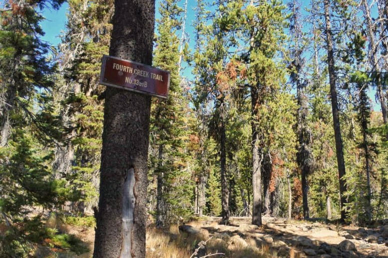
We hiked Fourth Creek trail headed north. Starting at the intersection with Beverly Turnpike Trail, there was a 0.3 mile uphill to the intersection with Hardscrabble Creek. We then headed downhill the rest of the way to Ingalls Creek.
The trail is well-maintained. There were a few trees that had fallen across the trail, but they were easy to circumnavigate. The two crossings over Fourth Creek were easy this time of year. The second crossing (lower down) is a delightful place to stop for lunch and fill up with water.
The trail is easy to find and there is no possibility of getting lost. Views of the Stuart Range are spectacular.
Fourth Creek, Bill's Peak — Oct. 4, 2018

![]() 1 person found this report helpful
1 person found this report helpful
Distance: 7.7 mi.
Elevation Gain: 3400 ft.
I was spending a couple days in Wenatchee, so I decided to take advantage of a great hiking day and go into the Teanaway Range. Besides some cows in the road and a few deep ruts, I was able to make it to the trailhead in our Honda Fit without much trouble. There weren’t any other cars in the parking lot, and indeed I didn’t see any other hikers all day.
I signed in at the trail register around 11 AM, crossed the bridge over Beverly Creek and then continued along the trail. I continued straight (left) at the first trail crossing and continued a slow, steady uphill until I reached a flat campsite. Here a couple GPS tracks I had downloaded went right, but I didn’t realize that there was a trail for me to follow so I totally missed it even though there’s a sign and everything. I found it on my down track.
 Look for this sign
I climbed a sparsely vegetated slope until I reached the southeast ridge of Bills Peak, then I turned left (northeast) up a steep scree slope (here’s the part where you actually have to go off trail). I found a few decent boot paths but it was a pretty slow slog up the scree field. On the way down I went farther skier’s left (east) where it’s more vegetated, and it’s probably a bit easier to go this way in both directions. It might have been a good scree field to plunge step down, but I wanted to preserve my new trail runners!
I eventually reached the scramble below the peak. There were multitudes of light trails to follow, but I tried following the most worn trails in hopes of choosing the best route. It worked out pretty well, but there were one or two 3rd class moves that I was able to avoid on the way down. The summit itself was on a rock outcrop above a large plateau. I took a kind of sketchy slab route up the east side of the rock outcrop, but there were better scramble routes on the southwest side. The route I took down was only a 2nd-low 3rd class scramble along a ramp, so keep an eye out for it. There were a few tiny patches of fresh snow that were easily avoidable.
 The only larch on Bills Peak
The views from the top were spectacular!!! Some of the best I have ever seen. There were a few larches in various directions, but only one that I saw on Bills Peak itself.
As I mentioned earlier, I took a slightly different route on the way down that was better overall. I found my way to the Fourth Creek Trail that I had missed earlier, which consisted of lots of dusty switchbacks. I reached Beverly Creek Trail and made my way back to the trailhead. I finished up around 4 PM.
Iron Peak Loop, Fourth Creek, Ingalls Creek, Longs Pass, Esmeralda Peak (Esmerelda) — Jun. 25, 2018

![]() 24 people found this report helpful
24 people found this report helpful
My boyfriend and I planned this trip the week before and only after I had a positive experience overnight backpacking with a friend the weekend before to Sandpoint out of Lake Ozette. I learned a lot from both trips, but I definitely found that my physical limits are not as low as I thought that they were. Difference between the trips were the number of nights, our mini Australian Shepards came with us on the long trip, the amount of food and overall the amount of weight we carried.
This trip started out early Friday morning and a little hungover. We start our trek down from the Esmeralda Trailhead at about 7am, where we parked the car, down to Trail 1399 which takes you to the ridge top near Iron Peak. We climbed about 3000 feet by mid-afternoon where the pups played in the snow on the top of ridge while we basked in the sights. We could see Rainier through the clouds to the back of us and rocky foot hills of Mt. Stuart to the front of us.
The gentleman we encountered on our first day had come up to hike Iron Peak and take come pictures with his dog. Unfortunately, our youngest pup is still getting socialized with other dogs and she got protective and nipped at this very mellow dog--something we need to work on with her. But the gentleman was nice and warned us that going down the ridge, the trail becomes hard to follow.
After that, the man went on his way and we packed up our things and found our way down the ridge. After the trail leveled out close to the base, it did become difficult to follow. My boyfriend searched for footprints and running water because that would direct us general down to the stream near the campsite, which it did. There were two campsites that we could camp at and we chose the first one because we were pretty tired and got it all set up by about 2pm.
The area this campsite was in was very interesting. You could hear the wind coming down through the valley and through the trees like a jet engine. It was a little eerie in the middle of the night because it would go from being calm to the sides of the tent getting pushed around.
Saturday morning, we filled up our hydropacks and naglenes with a Mini Sawyer filter at the stream near the campsite then packed up and headed out. We climbed 400 feet to the next campsite and where the trail T-off into two other trails: Fourth Creek Trail 1218 and Hardscrabble Creek Trail 1219. Now, the Green Trail Map 209 we were using has the trail numbers mixed up so I am including a picture of both the map and the trail markers to help anyone else going through this way. (I will be contacting them about this as well.) From there, we meandered down the Fourth Creek and caught sights of meadows of fragrant purple wild flowers and distant rocky ridges. The sights were breath taking! I just wanted to stand there as bask in nature's glory! But we had to move a long to get to our next planned campsite.
On this trail, there were some mixed obstacles of downed trees and fast streams. We also found some fresh cougar scat that kept us on our toes through there--though we did not see any scat that was more than a few days old after that. There were also a lot of goat hoove prints, but we also did not see any mountain goats along the trail. This trail led us down to the Ford near where Ingalls Creek and Fourth Creek meet which was not too bad to cross. One of our aussies is not a fan of water, so we had to help him a long but we were able to trek through it in sandels and trekking poles with no problem. After drying off and having a quick bite we were off--and by the way, this is when the misquotes finally appeared.
After a short distance, we made a left on Trail 1215 Ingalls Creek Trail which had many downed trees and a couple streams to pass. Through here we made a slow elevation gain through the forest. We came across a couple of smaller meadows until we reached a big one which we saw Sherpa and Argonaut Peaks to the right of us and the ridge that the Wilderness Boundry sits on to the left. Again, another breath taking spot that we could not just stand and look at all day.
We continued along the trail and passed many campsites as we got closer to the junction of Trail 1229 which would lead us over Longs Pass. We again had to cross a Ingalls Creek before we made out steep climb up to our next campsite, but this time the water was much more rapid and higher. There were a couple logs that we used to cross (as seen here). We had to be smart about going over because the dogs would not balance beam across. So first my boyfriend went with his pack while I held onto the dogs, then he came back for one then the other, and then I crossed with my pack. It was a little scary, but not undo-able.
After that crossing, we climbed up a rocky path up about 400 feet in about a mile to get to our campsite. Along the way up, we ran into another gentleman who was finishing up his day hike to Sherpa Peak from Esmeralda Trailhead! He definitely had done this before and had great pace! He wished us luck passing over the pass in the morning after getting a couple pets from the pups. When we got to the campsite and were resting a little before we set up camp at about 4:30p, another gentleman came up the path going towards the pass who had done an overnight over to Mt. Stuart. We chatted with him about Longs Pass which he said that he took out all of his winter climbing gear to come over it. This worried us because we did not have any climbing gear...we had my two trekking poles and our hiking boots.
At this point, we were considering either roughing it over the pass or backtracking about 14 miles we had already done to get there. We knew we only had about 3 to 4 miles to get back to the car from where we were and had all day to do it; but we had packed too much weight and the dogs were getting tired. We knew that we definitely had enough food to backtrack, but it would add at most another day to our trip.
After we had dinner, a couple walked by the campsite and we talked to them about the pass and they said that we would be fine going over. They said that all they used were spikes on their boots--which did not have but, they seemed to think that we would be fine without them all the same. They went along their way and before we fell asleep, another couple of guys walked by the campsite. We both tossed and turned about whether to go over the pass or back track the whole night. In the morning, we decided to go over.
We left the campsite about 6:45a Sunday morning after packing up and filling our naglenes for the trip up. We had redistributed weight because my pack was the heaviest for my overall strength.
We took it slowly up the side of the ridge because we wanted to make sure that we were as safe and careful as we could be. When we were half way up the side, there were a couple guys coming down who were heading over to Mt. Stuart and when we were about 3/4 of the up, there were a couple of guys who were coming from Mt. Stuart back to their car like us--but moving much faster up the ridge side. I saw that they climbing resin and lighter packs than ours. At the steepest point, we scrambled up the rocks and pushed the dogs over the longer jumps. And then finally, we made it to the top (me on my hands and knees) at about 8:15a.
The sight and the feeling of conquering that climb to go over Longs Pass was overwhelming. The whole night before we had doubted ourselves that we could safely make it. On the top, I could only think about how strong minded we all were: we carried too much weight, we had our dogs to worry about, and I am so out of shape to have successfully maneuvered over that patch.
On the way down to Esmeralda Trailhead and our car, we talked about how this was our new favorite adventure and how we were in awe of what we had just accomplished. Shortly down the trail, we encountered a man who was heading up and said that he had been hiking this path since before the area was titled a Wilderness and when they had originally made the trail to be a horse trail though he said that he knew that it would not stay that way.
When we got down to the parking lot at Esmeralda Trailhead, my boyfriend was in awe of the number cars in the parking lot at about 10:15a. When he had parked our car there three mornings before we could count the number of cars on one hand. I had done the Lake Ingalls hike before so I was not as surprised.
To sum up the points for my long story: bring micro-spikes for the for Longs Pass, pack smarter and lighter, and do a little better research about trail conditions so that there are no major surprises.