
Where to begin this trip report. Firstly, a huge thanks to Ultra Pedestrian and Co for coming up with a beautiful Wilderness Challenge (UPWC). The route is a point-to-point run between I-90 and Highway 2. Our group followed the advice of many others who recommended doing this from North to South, and we heartily agree. We completed the route as a single day push - 15 hours, and our GPS clocked in slightly above 30 miles and 10k feet of gain.
The route at this point is entirely snow free. Headed up from Seattle at 3:30 in the morning and were on trail by 5:30. The Necklace Valley Trailhead was packed with cars for backpackers when we arrived, and so we had to park along the side of the road. Don't forget your Northwest Forest/America the Beautiful pass. The trailhead bathroom is still definitely closed.
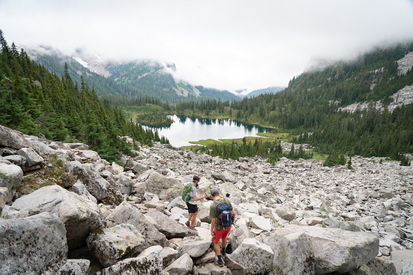
The hike through Necklace Valley is wonderfully relaxing, but has just enough ups and downs to warm you up and keep things interesting. Starting at 5:30 meant we needed headlamps for all of 15 minutes before we had enough light. We meandered through forests until reaching the first lake (Jade Lake). You gain approx 1000 feet, but it's pretty spread out and manageable. The trail is muddy in spots and a bit rocky and rooty - would've been much more challenging with a backpacking backpack.
Continuing on past Jade, Emerald, and Opal Lakes you can spot La Bohn Gap up ahead. Make sure you hang left whenever possible, hugging the valley wall. We went right, and ended up climbing the boulder field directly in front of us. We spent 30 minutes climbing the boulders before we realized we were entirely off our GPX track.
We backtracked and found the climbers trail which is directly next to a waterfall. This is the route, though it is highly non-obvious on approach. This is one of the steeper sections of the route, but breaking out on the ridge, next to the source of the waterfall is otherworldly.
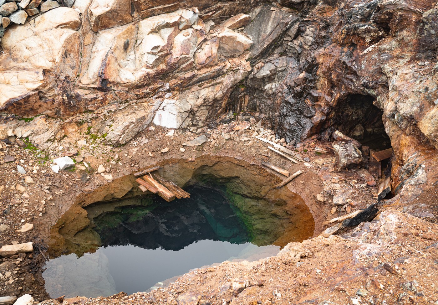
The chain lakes section was a sweet relief after the big climb, but soon the descent began and the boulder navigation began again. Again, there is no snow in this section. This is technically considered the "off-trail" section, but common human footpaths and game trails make for pretty easy navigation. One particular point of note is the stunning abandoned copper mine. The deep shaft was filled with water and the colors were absolutely breathtaking. Make sure not to miss this!
The descent down to Williams Lake is arduous and definitely slow going. Lots of boulder scrambling required. The lake also doesn't have a well-defined trail on the north side and we spent some time wrapping around until we finally hit the actual trail. This scene is magnificent - with towering rock faces all around you and an emerald green alpine lake perfectly placed between them. This is a cruisy running section, and we drastically picked up our pace here.
The section passed Williams Lake is a bit nondescript, but fairly quick as you are again on established trail. You are deep in the valley now. There are overgrown sections along the way, but eventually you will make it to Dutch Miller Gap and a road (gasp!). This really took us out of the "wilderness" aspect of the wilderness challenge, and as soon as we could we hopped on the Middle Fork Trail to immerse us back in it.
The Middle Fork Trail was good running terrain again, though nature was really out to get us in this section. We had two very close encounters with snakes on the trail, as well as an angry bee which stung one of our members. Eventually you hit a bridge with a split to Goldmyer Hot Springs, and you should head towards the Hot Springs. Huge shout out to the Goldmyer caretaker who gave us some fun trivia about the area and was a very kind dude.
We continued up the path to Goldmyer, down through their campsites, and then to a river crossing which required some log traversal to get across. One thing to note - there were unlimited water sources along this trail. We refilled numerous times and never ran out.
You then begin what is, in my opinion, the main crux of the challenge - climbing up to Red Pass. This section of trail is unmaintained and initially pretty hard to find. Hang left passed the river and eventually you will begin climbing. And climbing.. and climbing. Tons of debris all over the trail, blowdowns to go over and under, and unlimited zigging and zagging as you go from 2200' to 5400'. This section was a bit of a slog for our crew, especially after having already done 20+ miles. Luckily, the bonk hit each of us at different times, and we were able to maintain a consistent pace to the top.
After the long climb you reach a ridge, thinking that you've done the full climb as the trail begins to descend. Don't be fooled like us, you're not done! The trail immediately begins climbing again. The temperature was dropping and the winds began howling as we did this section, so we hustled up to Red Pass just to keep warm.
Once you hit the pass, all the gain you just acquired is descent down into Commonwealth Basin. This stretch has beautiful vistas and terrain. I would hate to have been going the opposite direction up it. You descend down into the basin until you reach a sign that ominously says "abandoned" but it was honestly the most maintained abandoned trail I have ever seen. Take this trail and avoid the PCT Section J! Eventually you will make it out at Snoqualmie Pass.
Overall this was an awesome, inspiring route. Make sure you do it with people you love, and it will make all the difficult parts more bearable. Also, the mosquitoes weren't too bad unless you stopped for any amount of time (especially around bodies of water), so don't stop. Finally, big thanks to David and Peter for pushing me through it and to Alex for picking us up at the finish line when we rolled in all haggard at 8:30, an hour later than initially estimated.


Comments