Goldmyer Hot Springs, Middle Fork Snoqualmie River — May. 15, 2025

![]() 25 people found this report helpful
25 people found this report helpful
Just back from a spur of the moment trip to Goldmyer that I am so so pleased worked out.
Since I'm working this weekend, I wanted to take a short little overnight after I finished work on Thursday afternoon. I was torn between rolling the dice on Goldmyer, which was showing 6 open spots but no way to reserve them, and a wildflower hike.
My colleague convinced me to try Goldmyer and holy cow am I happy I did. The grey weather would have made wildflower viewing less-than-stellar, but it was perfect for hot springs! I packed very fast, and was able to leave Seattle at 2 45pm. I needed cash since the springs are cash-only, so I stopped at the Bartells in North Bend. They're dismantling everything and selling off all their stock. It was sort of sad in there; I loved Bartells (as much as you can like a drugstore) and I'm really bummed they're all going out of business. But! The guy who helped me was really nice, so that was good. On to the trailhead; I arrived at about 4pm and was on trail by 4 30 or 4 45p.
I got very lucky getting a spot at Goldmyer, since I had to walk the whole road from the Garfield Ledges trailhead, and I was racing the light (as usual). I'd hoped to hitchhike to Dingford but just one car headed down that way before I left the trailhead, and I was still locking up my vehicle, so I missed them.
Roadwalk to Goldmyer
The road walk is straightforward and unremarkable but LONG. The potholes didn't look nearly as bad as last time I did that section of the road, but that may have been just because they weren't as full. The huge washout at mile...3? 4? is still wild - I haven't seen a vehicle navigate it and I'd love to.
Goldmyer checkin and payment
I finally reached the Goldmyer caretaker's cabin at 7 15ish, and one other couple was standing at the check-in. They'd already checked in as walk ups, but luckily there was still room for me! Walkup check in was easy: just one piece of paper to fill out and sign and handing over $40 cash. *Note* I misread their website and LUCKILY had gotten an extra $10 of cash when I was at Bartells, so had enough to pay for a site. Day use users pay $30, but campers need $40.
I set up camp first then headed to the hot springs. The caretaker said it was the only part of the hike that actually feels like a hike and she was right. It's narrow, rooty and steep, and much further from camp than I thought it would be: more than 0.3 miles.
Hot springs!
But boy are they cool. They're beautifully constructed, with a little warm pool for your feet I guess, because no way could you submerge in it. Connected to that is a warmer pool that about 3 people can fit in comfortably. Above that is an even warmer pool that really only fits one person, then behind that is hot pool, which really made it for me.
The hot pool is an old mine adit. Whoever built the hot springs built a wall about three feet tall at the mouth so it fills the adit, creating a pool that's pretty deep at the mouth but gets shallower as you walk back. It's probably 25 feet back. At the very back is a rock laid horizontal on the left that you can sit on and look out the tunnel. The steam from the heated water makes it a sort of sauna/steam room effect. It's incredible.
I soaked last night and this morning. The caretaker said Thursdays are cleaning night so I wanted to try to when they'd been freshly cleaned. Both times it was drizzling slightly, perfect hot spring weather.
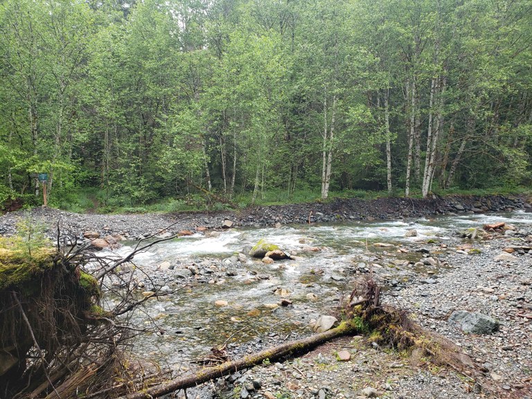
Leaving via Burntboot Creek and MF Snoqualmie Trail
After my morning soak (each pool for a few minutes, coolest to hottest, then 30s in the cold pool to wake up) I headed out. I crossed Burntboot Creek (below, Goldmyer sign visible on the far left), which was running pretty high. I am 5'10" and the water came up to a couple inches above my knees. I needed my crocs and hiking poles for the crossing for sure.
The MF trail is largely fine, improving in quality as you get closer to the trailhead, but one thing to note: The Wolf Creek crossing (I think) is gnarly. I would not have made it to Goldmyer if I had come that way last night. There used to be a log you could walk across but it got dislodged at some point in the last couple years and I was not comfortable trying to walk across it this time.
I butt-scooted, and even that was scary. The log is slippery and my hand slipped off at one point, causing me to almost lose my balance and fall in despite sitting down. Additionally, it's canted upwards as you hike downstream, so getting on it going upstream (toward Goldmyer) would have been really hard/dangerous.
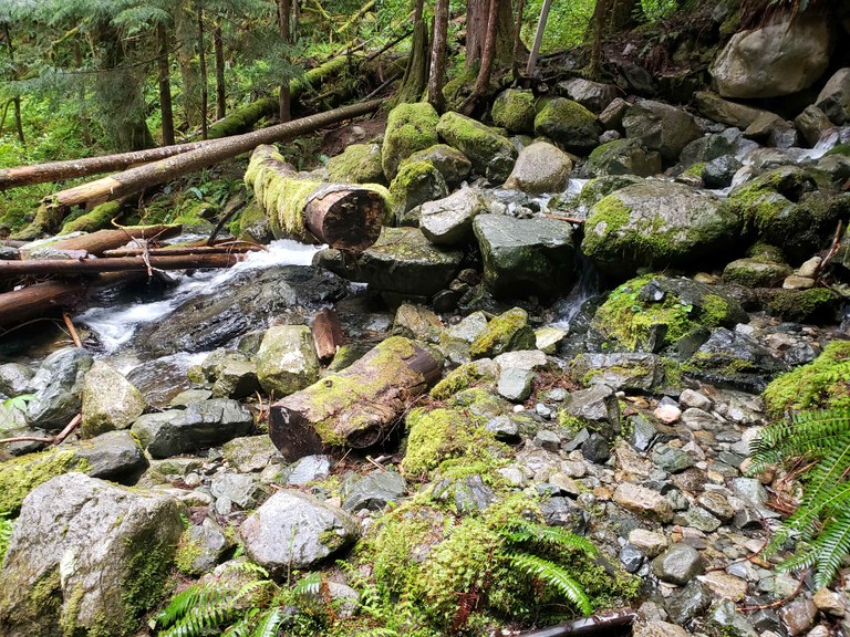
The log with the cut end facing the camera is the one I scooted on. It is possible there was a viable way to cross upstream of this, but I didn't see one that looked like a much safer option .
Aside from this section, the Middle Fork trail was fine, just interminable, especially as I was getting closer to the end. My feet stayed wet the whole time because there is a TON of brush between about a half mile past Rock Creek (heading towards the trailhead) and basically 4 miles from the end of the trail.
Last note: A firefighting crew was felling trees in the MF parking lot when I got there. They were really safety aware and walked me through the parking lot to the Middle Fork Connector trail so I could reach my car. Thanks guys!
Middle Fork Snoqualmie River — May. 11, 2025

![]() 11 people found this report helpful
11 people found this report helpful
My daughter offered to take me to the woods after church for Mother’s Day. She packed our snacks and picked an area she knew I liked. We walked a little less than a mile up the Middle Fork Trail. Everything is so lush and verdant right now! Trillium are mostly done, but other shady spring flowers are coming out, such as bleeding heart and bunchberries. We even found a couple of cool slime molds. Clouds were draped over the tops of the peaks, and rain showers came and went.
After hiking for about an hour, we drove up to the Garfield Ledges picnic area, set up our little shelter, and sat for a bit watching the river. My daughter made us coffee with cocoa on the backpacking stove. We need to do this more often!
The paved road is fine, but the gravel section after the turnoff for the Middle Fork Campground has some impressive potholes. I was worried even with my SUV. Toilets were in OK shape, but bring your own TP and hand sanitizer.
Middle Fork Snoqualmie River — Apr. 27, 2025

![]() 16 people found this report helpful
16 people found this report helpful
What a beautiful day. Having a tough time personally after a friend passed away suddenly and today I decided to forget my responsibilities and go for a hike. It was the perfect temperature, trail is in great shape, and the water was unreal colors.
Middle Fork Snoqualmie River — Apr. 26, 2025

![]() 9 people found this report helpful
9 people found this report helpful
The middle fork - it’s a great well-maintained trail. I loved the steep rocky part of the trail that hits a high point around 1.4 miles in, and wondered how they built that. Lots of undulating up and down, of course trending up as you go upriver. The trail has a split around 3.36 miles in to go down to the river, or stay right to stay on the main trail. The campsites 5.6 miles in looked inviting but I didn’t hike down to them. I continued on to the bridge crossing, then up to the Dingford creek trailhead. I was surprised to see a lot of cars there, all trucks and high clearance vehicles. Lots of TP in the bathroom, both on the holder and in the pit. Looks like it needs to be dug out soon.
I went a little further to the Dingford Creek Falls (at approximately 6.3 miles). Definitely worth the extra short distance. Then headed back. The color of the river is pretty cool – a light emerald green.
All dogs and owners were well behaved. I saw some climbers, and a few backpackers, but mostly a lot of very happy trail runners.
12.78 miles RT, 1781 feet total ascent
Middle Fork Snoqualmie River — Apr. 26, 2025

![]() 2 people found this report helpful
2 people found this report helpful
The bugs are really coming out along the Middle Fork. We hiked later in the day. Fortunately none are biting yet, but in several of the wet parts of the trail we were moving through clouds of them.
Overall, the trail is in great shape. It's nice that a lot of the best views and river access are at the start of the trail, so there's really no need to get somewhere or to a particular point. You can just enjoy walking in the forest. We did around 4 or 5 miles total.
We probably encountered a couple of dozen other hikers, but for a perfect sunny Saturday, there were not a lot of people. Parking lot had plenty of space.