Shedroof Divide - Mankato Mountain Logout
Backcountry Response Team
 Fri Jul 24, 2026 8:30 AM — Mon Jul 27, 2026 3:30 PM
 Sign in to My Backpack
 Region
Eastern Washington — Selkirk Range
Features: Earn Northwest Forest Pass
Crew Leader: Holly Weiler
Overview
Join a crew in the rugged Salmo-Priest, the only wilderness area in the northeast part of the state. You'll have the chance to work on a section of the Shedroof Divide Trail at Mankato Mountain, near the southern end of this trail.
About the Area
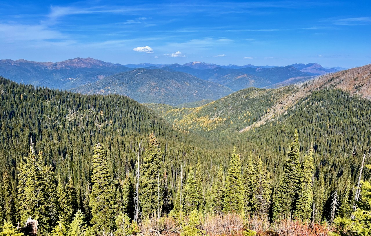
The Shedroof Divide Trail dominates the Salmo-Priest Wilderness, traversng Crowell Ridge for 22 miles from Snowy Top Mountain near Canada south to Pass Creek Pass. Along the way, pass Mankato Mountain, the base camp for this trip.
Views from the top encompass the Okanogan Highlands in the west to the spectacular Idaho Selkirks in the east. Wildlife abounds in this corner of the state, including moose, wolves, grizzly bears and even woodland caribou.
What to Expect
We'll have fun, work hard and make a difference!
Project Description
We will meet at Gypsy Meadows at the start of this trip in order to set up a shuttle that will enable us to work one-way. On day 1 we will carpool to Pass Creek Pass to begin work on the Shedroof Divide. We'll do logout, brush, and do tread and drainage repair, moving camps as we go. If the maintenance needs are high our goal will be to work as far as Thunder Creek to exit. If we are able to make it beyond Thunder Creek, we may exit via Shedroof Cutoff instead, then return to Gypsy Meadows to complete the shuttle.
Camping and Hiking Information
- Type: Backcountry camps
- Location: Just below Mankato Mountain and near Thunder Creek &/or Thunder Mountain
- Weather: Be prepared for variable conditions including heat, cold, wind and rain
- Initial hike to camp: 4 miles with 900 feet of gain at a moderate pace while carrying your backpack fully loaded with all provisions including camping gear and food, plus WTA-provided tools.
- Expected daily hike to project: 4 miles roundtrip with 500 feet of elevation gain at a moderate pace
Schedule
- Day 1: Meet the crew rain or shine, then hike in, begin work on the project and set up camp
- Day 2+: Make breakfast and pack a lunch before heading out on trail with the crew by 8:00 AM. Work at your own pace, take plenty of breaks and enjoy lunch on the trail. Arrive back in camp by 4:00 or 5:00 PM for a relaxing evening. Prepare your own dinner and swap stories with the crew.
- Final Day: Break down camp, finish trail project, hike out and say goodbye to the crew at the trailhead
For safety reasons, arriving late or leaving early is not allowed.
Planning Information
Get ready for a challenging backcountry adventure!
What it Takes to Do This Work Party
- A great attitude for working with a team! WTA provides the training and tools you need for the project
- Backpacking gear and food for multiple nights on the trail
- Good physical condition to hike with a fully-loaded backpack and be physically active for about 8-9 hours daily on uneven terrain
- Backpacking experience including ability to run your own camp following Leave No Trace principles
- Day work party experience recommended
- Flexibility to adapt to changes due to unpredictable weather or land manager requests
- Minimum age: 18
What to Bring
Required:
- Sturdy work or hiking boots. Review our Logout Boot Guide for more details.
- Work gloves
- Eye protection (glasses, sunglasses, safety glasses, or mesh “bug eyes”. Glasses should have wrapping side shields. ANSI Z87.1+)
- Long pants
- Long sleeve shirt
A hard hat will be provided by WTA if you do not already have a WTA provided hard hat. Additionally, work gloves and eye protection will be provided by WTA if you do not have your own, but when possible we recommend bringing your own. For safety reasons, certain tasks may be assigned based on the safety level of your footwear. Volunteers who do not have long pants, or sturdy closed toes shoes, will not be able to participate in the work party.
In addition to items listed above, bring the following backpacking gear:
- WTA hard hat
- Work gloves
- Backpack to carry all of your gear
- Tent, sleeping bag and sleeping pad
- Cooking gear and enough food (plus a little extra) for the entire trip
- At least two 1-liter water bottles and a way to purify your water
- Rain jacket and rain pants
- Extra warm clothing
- Camp clothing such as shorts, shirt and sandals
- Sun and bug protection
- Headlamp and extra batteries
- Personal items such as medication, hand sanitizer and toiletries
- First aid kit
- A sense of fun and adventure for learning new skills and meeting great people!
A hard hat will be provided by WTA if you do not already have a WTA provided hard hat. Additionally, work gloves and eye protection will be provided by WTA if you do not have your own, but when possible we recommend bringing your own.
More Information
- What to Pack for a Backcountry Response Team
- Frequently Asked Questions
- WTA's Trail Work Guide introduces the type of work you may do
- Contact us at volunteer@wta.org or 206.625.1367
From the Hiking Guide
See what WTA's hiking guide and trip reports say about this area.
This is a preview. Registration will open soon.
Partners
Directions
The meeting point will be Gypsy Meadows. The drive from Spokane to Gypsy Meadows is a about a 2.5 hour drive, not including stops. From Spokane, take Highway 2 north to the junction with Highway 211 (look for signs for Cusick, Metaline Falls, etc.). Head north on 211 to the junction at Usk and turn left onto Highway 20. Continue north on Highway 20 for 31 miles to the rest area/museum at Tiger where highway 20 turns left towards Tiger Pass and Colville. At this point continue straight ahead on Highway 31 and go another 3.1 miles and just as you’re entering the outskirts of the town of Ione, take a poorly marked right onto paved County Road# 9345/Sullivan Lake Road, which should have a sign directing you towards Sullivan Lake. Cross the river and stay on road #9345 (the middle road option) at the multi-road junction on the east side of the bridge and then continue on about 12 miles through the woods and along the lake to the Sullivan Lake Ranger Station and campground. Continue past the Ranger Station compound on your left and in about 0.5 miles turn right onto Forest Service Road 22 / Sullivan Creek Road (this is not always well marked). Drive about 5.5 miles and keep to the left at the major Y junction with the turn-off to Pass Creek Pass. This will put you on FS 2220. Follow this for 6.5 miles to Gypsy Meadows Campground on the left where we will meet.
Note: Please follow the written directions above instead of using a GPS device. This will ensure that you get to the correct meeting location for this work party. The location of the pinpoint below is only approximate.
Getting to WTA work parties can involve travel on rough, unpaved roads in areas without cellular service and without street addresses that can be accurately used by navigation devices. Unless specifically noted otherwise, routes can generally be traveled by all types of vehicles. Volunteers with limited experience driving on unpaved mountain roads may want to allow extra time, beyond what is recommended in the directions above, to get to the meeting location.
You must be part of this crew and have a My Backpack account to see the Crew Corner.
Sign in to My BackpackWhat is Crew Corner?
Crew Message Board
Stay on top of this work party’s messages.
Carpool
Find a ride, give a ride with people who also want to carpool.