
This is a very overdue trip report for an attempt to hike the Boundary Trail this summer. I’m too late to be helpful to anyone this year, but hopefully this will provide detail on some of the lesser hiked portions of it for next year’s planning. In summary, we hiked EB from Irongate with an intended exit at East Bank TH, a total of ~130 miles, over 10 days, but due to trail conditions and an injury, exited at Slate Pass, with a total of ~90 miles over 7 days. Trail conditions were great from Irongate past Cathedral Lakes, but became increasingly more challenging from the Ashnola River to the Pasayten Guard Station. We did not hike from the air strip to Frosty Pass, but reports from 3 other hiking parties coming from that direction were that the trail was equally challenging east bound from the PCT to the Pasayten Guard Station. Water was plentiful at this time but the bugs were terrible -- 2-3 weeks later in the year would have been better. More detail is provided below, if you are interested.
Road Conditions:
We got dropped off at the Irongate TH, leaving our car along the way at the East Bank TH. FS Road was bumpy but made it up a Honda Accord Hybrid. Call Forest office to confirm road conditions next year; they were very helpful to us. Very long drive from Seattle! Camped overnight at TH; there is a small campground with a loo, but no water -- first stream will be about ½ mile in on the trail.
Detailed Report
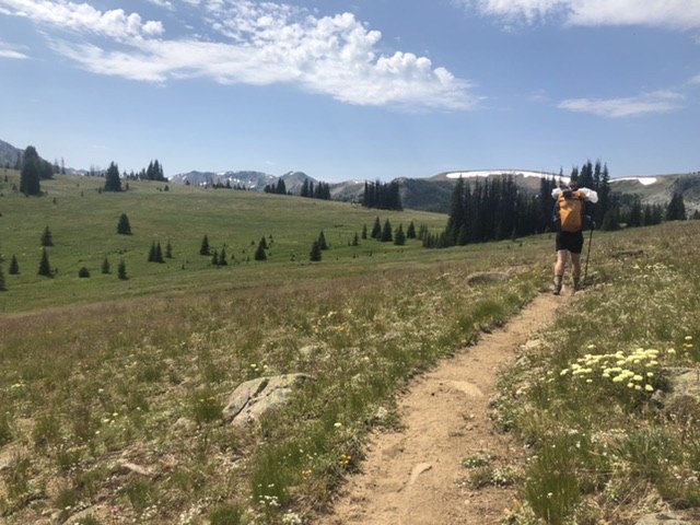
Amazing wildflowers literally blanketing the earth on our approach to Horseshoe, the air was incredibly fragrant. Water about half mile in, and then again just after Sunny Pass, a short 100 or so feet from the trail, with an established foot path. Water at Loudon was clear and delicious and we enjoyed a swim here. Great camp spot just before the foot of Haig Mountain (about 11 or 12 miles from TH) with a well-established pad and easy walk to stream with very good flow. I would expect this to run into August, and was also the only strong water source between Loudon and Tungsten. Bugs were terrible. Fresh mountain lion droppings spotted.
Trail to Tungsten was clear and easy to follow. Due to signs of a lot of mice, I would not recommend sleeping in the cabins unless necessary, but we did hide in there to eat and filter water to get a break from the bugs. Pit toilets just uphill from the cabins, kind of hidden until you practically walk into it. A stream nearby had good flow at this time of year, but we had to fill pots and pour into our filter. Later in the season, you may need to hike further SE to tap into the creek downstream. No other major water sources from here to Cathedral.
The climb to Cathedral from Tungsten is very pleasant, with excellent views. Lots more flowers, lots of mountain goats, plenty of water, good swimming in the by-then snow-free Upper Cathedral Lake, LOTS of bugs and good company! -- we socially distanced with a number of other backpackers.
From Cathedral we hiked to Ashnola. I don’t recall any water until Spanish Cabin, where we refilled from a roaring creek, and utilized a pit toilet. From here to the descent into Ashnola, we passed through quite of a bit of burn. I would not recommend camping in this stretch, however, we did encounter some PNT trail crew tents near a stream flowing near the foot of Bald Mountain. Then we crossed gorgeous meadow until the drop down to the river, which quickly became overgrown and rocky, and after 2000 ft of descent, my ankles were very tired. There was a great camping pad and obviously plenty of delicious river water, and sitting by the river provided bug relief. Fording the Ashnola was easy by this time.
The next morning we climbed right back up that 2000 ft to Peeve Pass. The first mile was densely overgrown, but it was still easy to identify and cleared up as we got higher, and so began maybe some of the most immensely beautiful trail I’ve ever hiked, with breathtaking panoramas of endless peaks, miles of wildflower covered hillsides waving in the wind, and not a soul in sight, except for a moose. It was incredibly quiet and still and partly sunny and we did not speak much. We passed Sheep Mountain but did not go looking for the lake, the trail seemed to whisper off into the meadow. There was a creek with great flow at the bottom of Peeve where we lunched before approaching Bunker Hill. Rounding Quartz Mountain was fairly navigable, and there was a creek with excellent flow at the low point between Quartz and Bunker. This was the last water until we camped. (However, you could hike down and camp near Quartz Lake -- the trail was obvious, but overgrown.)
Climbing Bunker Hill was very challenging navigationally, due to serious burn, blowdown, and landslide interruptions. I recommend having strong navigation skills or a GPS for this segment, as it is an easy place to get lost. Gaia & USGS maps were very helpful, and just remember to stay on the ridgeline up and over Boundary Hill -- around 7000 ft, the burn dissipates and the trail becomes visible again in the meadow. The views from Bunker Hill are absolutely jawdropping. Then we dropped down toward the Bunker Hill Creek, through gorgeous heather meadows. We camped by the creek, which was flowing strongly at this time and there is a well established campsite just before it. Still quite buggy.
The entire next day we hiked again through challenging burn, blowdown and lost trail. Again, strong navigation tools are recommended. You can see the evidence of so much work from summer of 2019, however -- it was challenging, but absolutely possible due to the work of WTA and PNT, and we did okay with the use of an app. Between camp and the river, there was another cross of Bunker Hill Creek, which was rushing strongly here. We encountered two other parties here and commiserated about blowdowns. One couple was doing the entire PNT, covering about 20 miles a day, and they said they were challenged, which consoled us slower pokes. From here, we whacked our way to the Pasayten, which was an easy ford at this time, slow but knee deep in places. The reroute here going westbound is well-marked, but we heard from the couple that eastbound, it was not, and they had taken the old, unmaintained route.
On the west bank of the Pasayten, the bushwhacking continued through burn and river plain. Again, we saw signs of trail crews the previous year, and we were very grateful! But the blowdowns in here were the hardest, as they were almost all at hip height, and so required either belly crawls in the mud through branches, or hopping over with full packs on. I have a few scars. Lots of fresh bear scat in here. There are several creek crossings, two were knee deep. Otherwise you remain high up above the river the whole time. Note, there is pretty much nowhere to camp between the Guard Station & the Bunker Hill site, due to extensive burn, steep terrain, and blowdowns.
We finally made it, bruised and tired, to the Guard Station. Excellent camping with a water spigot, pit toilet, and firepit, beside a meadow. We camped with neighbors for the first time in a few nights. Bugs were much better.
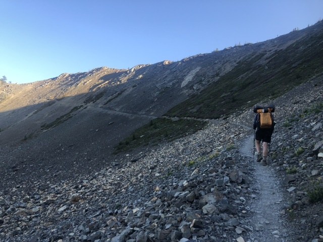
Our hike out was a big day, about 18 miles from the Guard Station to Slate Pass. We opted for the Middle Fork. Aside from a confusing reroute sign, the trail was in great condition, had recently been cleared and we were able to move quickly for hours. The gentle downhill gradient felt amazing. Water was plentiful and we saw lots of established camp sites. We struggled a little to find the connection with the Robinson Cutoff, as the trail gets a little zigzaggy at the creek -- but only from WB. Once we found the trail on the other side of the creek, we realized it would be very easy to see EB. Good flow at the creek. Finally, we ended with that brutal climb from the creek to Slate Pass. Steep, rocky, and already very dry in here by late July. Amazing views the whole way up. The last quarter mile of dusty basin to the pass is wild -- hard, and then you’re rewarded with that amazing pass view on the western ridge. We camped at the lovely little fee campground about 2 miles down the road. I did not see water here.
We exited early, but based on reviews, the trail would have continued to be challenging from the Guard Station up to at least Frosty and the PCT junction. Overall, a really amazing week in the Pasayten, with some of the most rugged solitude we’ve every enjoyed. While we met some trail vets out there, we are not, and we found this to be challenging in every respect, but very gratifying. I highly recommend strong navigation skills & preparation, going a few weeks later to minimize bugs, and being prepared for lots of hopping over trees. Thanks to all of the trail crews who’ve been working on this trail recently -- while blowdowns are inevitable, I literally could not imagine getting through all of this trip without the work they’ve done already! This is an amazing part of the world and it’s even more amazing that folks are keeping it accessible.

Comments
A fun read and thanks for sharing your hike. Too bad about the injury. I applaud your attempt at hiking beyond where most think the Boundary Trail ends, picking the East Bank TH for your exit. Very few attempt that, and even fewer attempt to hike all the way to the Hannegan trailhead, the true western terminus of the Boundary Trail. Cool that you saw a moose, too.
A great adventure! : )
Posted by:
Sir-Hikes-A-Lot on Mar 14, 2021 03:18 PM
thanks! i wound up in PT for that ankle for a few weeks, but now that winter has waved its magic spell, i've forgotten all about it and we are going to try for permits to hike from hannegan pass to the lake this summer -- thanks for mentioning it! your reports are always so helpful, much appreciation for all you share.
Posted by:
Happyskillet on Mar 21, 2021 05:22 PM
Thanks for the very helpful TR! I hope to do the Boundary Trail one day and this will be useful.
Posted by:
Lenore on Nov 22, 2023 04:37 PM