

Today I hiked the Silver Falls Trail from Ohanapecosh CG, and attempted to get to the Grove of the Patriarchs. Here are the THREE most important things you need to know:
THE SUSPENSION BRIDGE TO GROVE OF THE PATRIARCHS IS DAMAGED, UNSAFE, AND CLOSED (at least as of this morning). Two rangers inspected it before I got there, and they told me on the trail that it was closed for now. You can see in the photo that the water rose almost to the bridge (!!!) - they think a heavy log struck the bridge (you can see damage about halfway across), and they also noted that where the bridge attaches to the land, it has started to come loose. I probably would have foolishly tried to cross it, so a big THANKS to the rangers for their wisdom.
SILVER FALLS IS A RAGING TORRENT, BE CAREFUL WHEN APPROACHING IT. I know conditions can quickly change, but as of this morning, it was like Niagara Falls. Holy cow. In the summer, my kids and I would (carefully) venture out onto the rocks by the falls. You can see in the photo that the water is raging over those rocks right now. It is also spraying a lot at the official viewpoint near the rocks - I got soaked trying to get a good photo.
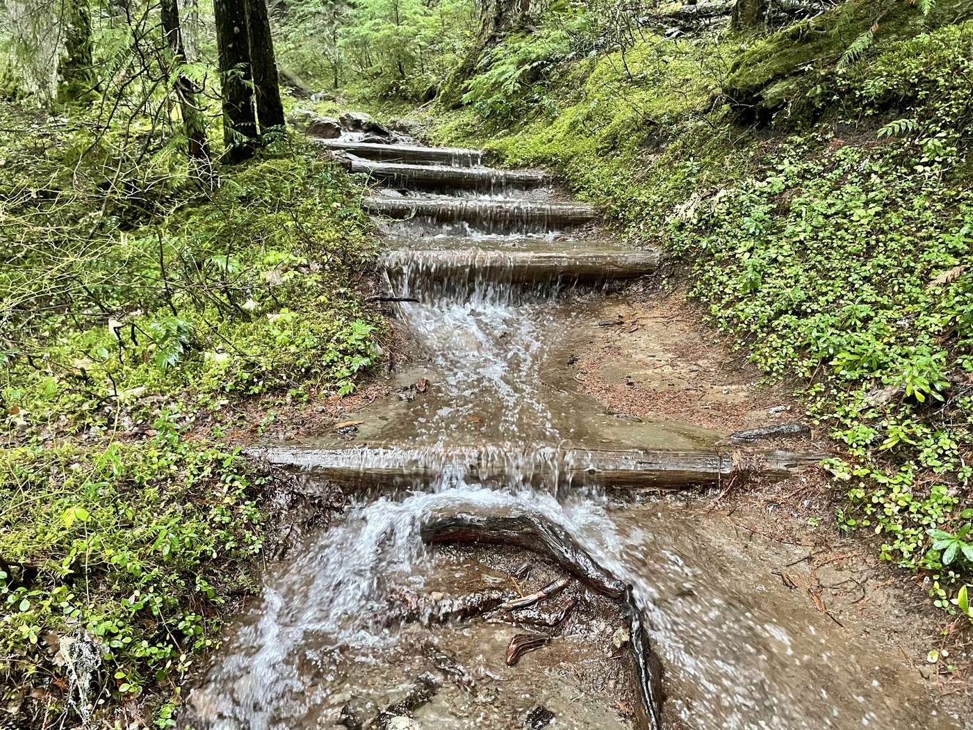
ALL OF THE BRIDGES ON THE SILVER FALLS LOOP ARE STILL UP. I felt safe hiking the entire loop, as well as on the trial from Silver Falls to Grove of the Patriarchs. There are a couple of bridges that have water backing up behind them, so I don't know how long they will last. A couple of short boardwalk sections are washed out, but those did not pose any danger.
If you want to see more pictures and a few short video clips, copy and paste this link - it's really hard to describe how much water is up there right now.
https://photos.app.goo.gl/s3Mz3FfSaoAJP1aw8
Here is the longer narrative of my adventure this morning:
I am usually a sunny-day hiker, but today was the best day for me to hike, and so I ventured into the mountains, even though it called for rain, rain, and more rain. It was definitely wet, but I am really glad I tried it. I think I could get used to rainy-day hiking ... maybe.
I left Yakima at 6:15am, drove over White Pass, turned north on Highway 123. It rained the WHOLE TIME.
Quick bathroom update - the bathrooms at the scenic view just east of White Pass are still unlocked, I also saw a few porta-potties outside the Kracker Barrel at the top of the pass (and the bathrooms at Grove of the Patriarchs were unlocked as well). BYOTP of course! Ohanapecosh bathrooms were locked.
I was able to drive to the national park boundary - I parked at the closed gate, and walked the mile to Ohanapecosh. Did I mention it was raining? So. Much. Water. Every creek was a raging waterfall surging under the road, often both sides of the road had creeks going down them. A few places the water was crossing on TOP of the road, but never too deep. It was wet, green, and beautiful.
I wore hiking pants with a base layer (both soaked by the end - maybe I need to invest in rain pants?), a short sleeve shirt and a raincoat. My upper body stayed mostly dry, though I walked that fine line between staying warm and sweating. It was 50 degrees the whole time, so not very cold. I also wore my baseball hat. On the road, I had my hood up, but once in the trees, my hat kept most of the drips off of me.
I was glad to have waterproof boots and poles, a few times the water was up to my laces. But I'm sure you could trail run this thing in shorts and a t-shirt, knowing you would just be soaking wet the whole time. The smartest thing I did was line my day pack with a garbage bag, which kept everything dry. Highly recommend.
I dried out a bit at the visitor center covered porch, then walked to the bridge going over the river. I don't think I've ever seen that much water, even in the spring. In the photo looking south, the rocky point sticking out is where people jump off into the river - usually it's like an 8-foot drop. Not today!
I headed to Silver Falls (counter-clockwise around the loop). Still raining. The trail is often a creek, occasionally a waterfall, and sometimes a pond. Never too deep, but I did keep my eyes on the ground, navigating through all of the water features. All of the bridges are in, but the creeks are raging, and my usual thoughts of "if I fall off, I will get wet and be embarrassed" were replaced by "if I fall off, I will be immediately swept to my death."
Like I said, Silver Falls is raging. If you stay on the trail, you will be fine. There's just a LOT of water, and a lot of spray, especially at the viewpoint.
I kept going to Grove of the Patriarchs - still raining, still lots of water on the trail. Lots of standing water off-trail in the woods, too. I reached the Stevens Canyon Road, crossed over, and kept going. This is where I met the two rangers who had just inspected the suspension bridge. They said it was fine to take photos, but to please not cross it. Maybe by now it is officially blocked off, I don't know. They didn't say when it would be fixed.
I took a few photos of the bridge, also noting that the Grove (what I could see, at least) looked flooded as well. I sometimes worry that weather events like this are signs of climate change, and that soon we will be talking about the days when we USED TO be able to hike to the Grove of the Patriarchs...a little unsettling.
Heading back, I took the west trail of the loop back to Ohanapecosh. Definitely less water on the trail on this part, maybe due to higher elevation and further from the river. Took a break at the visitor center again, then hoofed it down the road to the gate. It really started to pour for this last mile, Mt. Rainier's parting gift to me. I was so grateful to climb into the car, crank up the heater, and change into dry clothes.
It was definitely a wet hike, but I have no regrets. I was surrounded by beauty, and the only creatures I saw were the two rangers and a few birds. I found it renewing, and the familiar trail was surprisingly new and different this time.
Total of 8.8 miles, 1000ft elevation gain, just over three hours total time.
Conditions can quickly change, but this is what I experienced Friday morning, 11/12.


Comments
WOW! Those photos! SR
Posted by:
stever on Nov 12, 2021 04:09 PM
That is one great trip report! Fun to read. Climate change real, and, after over 50 years of hiking, I see it's effects every year in every season!
Posted by:
cascadesdj on Nov 12, 2021 04:34 PM
"climate change" LOL. This happens ** every year ** when we get snow in Oct. / Nov. and then we get a pineapple express hitting the area = snowmelt! Its quite normal actually, and noticeable by anyone who has lived in the area longer than 10 years.
Posted by:
Yama otoko on Nov 13, 2021 01:11 PM
Yama, I’ve been glacier hiking/ climbing since the early 70’s and live in snow country. There’s been a huge shrinkage of glaciers in every decade since. Sure, glaciers have always come and gone—over thousands of years. This is different. It’s happening in years and decades!
Read up, look at the old pictures adjacent to the current ones. The evidence, and over 97% of actual scientists—-not politicians—-agree. It is in the economic interests of some to dupe the public with lies and disingenuous arguments. Study up!
Posted by:
cascadesdj on Nov 13, 2021 07:39 PM
OMG! That’s a lot of water!!! Thanks for the pics!
Posted by:
hikingwithlittledogs on Nov 12, 2021 05:40 PM
Wow! So much water! Insane. Thanks for the update! Very sad about the bridge; was thinking of trying to get down to the grove this winter. Guess not. Also thanks for the update on the road and bathrooms! WSDOT site claims 123 is open from the south to Stevens Canyon Road; MRNP website notes (correctly it seems) that it was closed at the park boundary.
Posted by:
glucas on Nov 12, 2021 09:20 PM
It might be awhile before that bridge is repaired. We are still waiting for the bridge at Big Four Ice Caves to be repaired here on the West side. Of course, Big Four requires a whole NEW bridge. This looks repairable with just a few hands. :)
Awesome trip report as always.
Posted by:
Seattle_Wayne on Nov 13, 2021 05:00 AM
Incredible! Great report.
Posted by:
I ❤️ Trees on Nov 13, 2021 01:35 PM
Thank you for an excellent write-up on one of my favorite hikes. The pictures are wonderful too.
Posted by:
bettyat on Nov 14, 2021 10:20 AM
Thanks for the great report! I'm glad you were able to experience the beauty of a rainy hike.
Posted by:
Lenore on Jan 06, 2022 08:04 AM