

The weather forecast was calling for stormy rain, more today than tomorrow, so today seemed like a good day to go. Rain down here means snow on the mountaintops! I had only made up my mind to go at 0830, and my gear was scattered all over the garage in various bins, so wherever I was going to go it was going to have to be close. I decided on either Mt. Zion or Mt. Townsend. Zion is a short relatively easy hike to the summit, but it isn’t much of a summit as summits go. The trees get in the way of the views (if any), and the knife-edge hike to the north to the clear area didn’t sound terribly appetizing with the knife edge being icy. Townsend is about twice as far to hike, with more elevation gain, but its summit is treeless, long and broad. I figured I’d make up my mind at Quilcene; turn north to Zion or south to Townsend.
A large part of my decision was going to be my energy and motivation levels. It’s been eight weeks since I struggled up to the summit of Colonel Bob, and in all that time since I’ve been a total slug. I thought about that a lot while I assembled my pack. As I headed west the sky was completely overcast but it wasn’t raining. I arrived in Quilcene and since nobody was behind me at the stop sign, I paused for a moment to make up my mind. Zion isn’t much of a challenge. Well, maybe I’ll just see how far up the Townsend trail I can get and if it’s kicking my butt, I’ll stop wherever I am and turn back. I steered the jeep left and headed south towards Penny Creek Road.
There were only two other cars at the upper trailhead so I guess the bad weather was going to keep the tiny parking area a little less crowded than it is most Saturdays. I left the trailhead at about 11am with snow falling lightly. I didn’t have a GPS and I forgot my watch, so I had no way of calculating a turn-around time. This trail starts out steep, then climbs a bit more gradually until you near the top, and then it’s steep again. The initial climb left me gasping for breath! I decided to slow my pace and try not to sweat too much; I didn’t want to be soaked when (if) I got on top. I passed a few other hikers on the way up, more than there were cars in the parking lot, so I figure a couple of them were hearty enough to have started from the lower trailhead.
The trail was mostly snow free except for the parts that were exposed to the sky; these had a light dusting and I had no problem with traction. I passed the Silver Lakes junction and here the snow began to get a little deeper, so I stopped near the frog-pond and put my microspikes on and ate one of my PB&Js. Thanks to a lot of daydreaming the bulk of the hike had gone by without me giving much consideration to how horribly out of shape I felt, and before long I could see the long summit of Mt. Townsend peeking through the fog. I stopped to talk to three hikers on their way down from the summit who reported very high winds and blowing snow. As it was I was wearing only two layers, one nylon and one capaline (issued to me by the USAF back in 1990), under my unzipped hard shell. I wasn’t wearing a hat because it was just too hot with the long climb, and I was wearing my summer hiking pants without any long-johns underneath. Beginning my final climb up the exposed part of the trail the wind, which wasn’t blowing anywhere along the hike, began to pick up.
As I neared the final push on the east facing slope to the summit the wind began to howl, picking up snow from the western slope and blowing it over the top. It was easy to see it coming, but bracing and turning to let it hit me in the back wasn’t working as the wind would swirl all around me in a tiny snow tornado. It was hard to keep the stupid grin off my face. I was also struggling because I was flat wore out. As I climbed up the eastern face, I decided to divert up into a grove of stunted firs to get out of the wind somewhat. There I would be able to eat my lunch and put the down liner in my coat (and zip it up!). I dropped my pack in about eight inches of snow, zipped up my coat and tried to put my hat on. My hair was frozen; it felt like I was wearing a hard-hat! Instead of lunch and coffee, I pulled the ham radio out to try to make a contact. I started with the simplex common frequency of 146.520, calling CQ. It took another try before I got a response from K7PC up in Mt. Vernon that he was reading me. We chatted a bit and I had to ask him the time as I was worried I might be hiking out by headlamp in the dark. I also asked him to send an email to a certain g-mail account we have set up.
With that taken care of I decided to forgo lunch for the moment and just hike the last few hundred yards to the summit with only the radio and my camera. The wind howled in protest as I shot a few pictures and made a quick video. As I walked along the summit in the blowing show, one gust just about lifted me off my feet. I wasn’t terribly comfortable being that far from my gear, in the almost white-out conditions at times. My hands were about frozen whenever I took them from my pockets and I wandered around on the summit only briefly before starting down. Back at my little nest in the trees, I tried a couple repeaters (Bremerton and Northbend) and was able to easily trigger the repeaters but got no reply. By now I was very cold and rather than sit in the snow and wind I decided to pack back down to the tree-line before trying to eat my lunch.
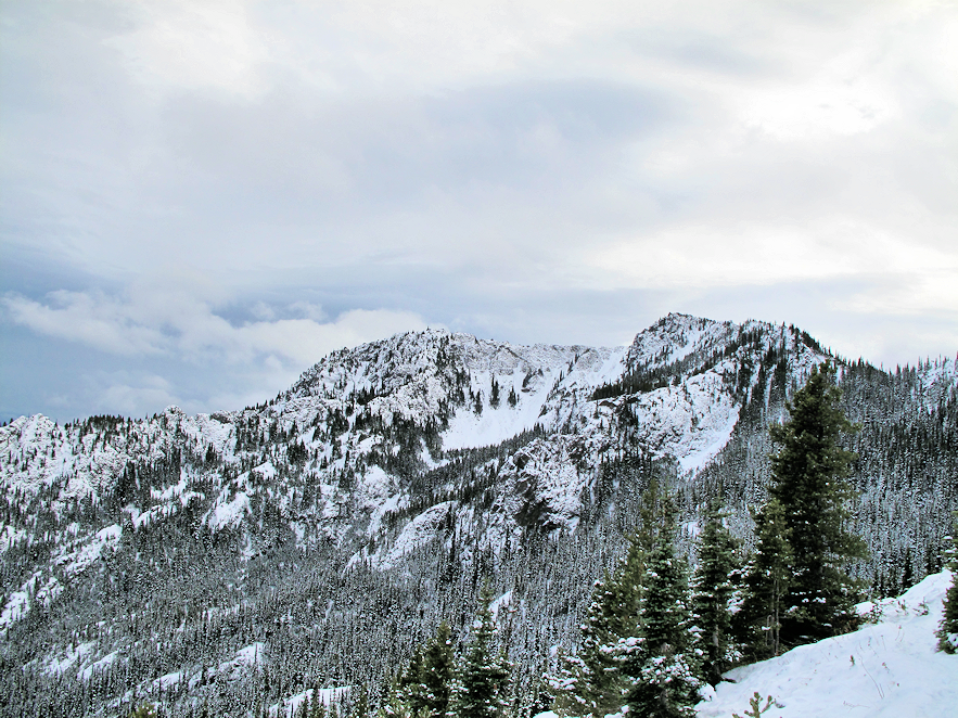
As I made my way down, the trail turns to where you can see up to the summit and… wait… is that blue sky? No sooner had I left than the sky immediately over the summit had cleared and the wind died down. Out to the west the sun broke through the clouds low over the range, illuminating the mountainside. The angle of the light seemed to amplify the contrast of the green fir trees and the white snow on their boughs; it was breathtaking! The rest of the hike down was uneventful and I arrived back at the parking area right at dusk.


Comments
Posted by:
MK19 on Apr 16, 2012 11:25 PM