
Stats (mileage and elevation from Gaia):
- 5 days, 4 nights Counter-clockwise Loop
- Campsites: Copper Creek Boundary Camp, Indian Creek, Copper Lake, Silesia
- 33.57 miles
- 11,689 feet of elevation gain
- 11,740 feet of elevation loss
Hiked in on August 18, and hiked out on August 22. This trail is beautiful, but easily the hardest I've done so far with the constant elevation swings each day.
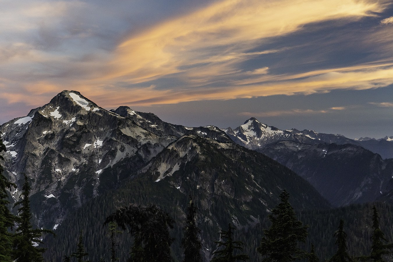
Day 1 - 5.11 miles, 2371' gain, 1078' loss - TH to Copper Creek Camp Boundary Camp: Got to the trailhead and started out around 1:30pm the first day. A terrible idea to start so late, as it was a scorcher of a day. Mid to high 80's, with high humidity, sun, and absolutely zero wind. From the trailhead up to Hannegan Pass was like hiking in a sauna/steam room. The air was so thick in the valley it made my usual slow pace 10x slower. While the mileage and elevation gain in this section should be relatively moderate, it took forever with a ton of long breaks, and I'm quite sure we were all showing signs of heat exhaustion. To make it worse, any time you wanted to stop you would instantly be swarmed with biting flies. 100% Deet helped for a small amount of time, but after awhile it didn't even matter - those flies were going to bite you and it didn't matter how many chemicals you doused yourself in. The way down from the pass was mostly shaded by that time, and a welcome relief. Flowers were past their peak, but the bees and butterflies were still doing their best to pollinate.

On that note - there is a wasps nest in the trees just off the trail by the boundary line. It's one big ball of NOPE.


They weren't aggressive, but I wasn't hanging out for long so see if they wanted to change their minds. By the time we made it to the boundary line for the National Park, it was 7pm and we still had 2.7 miles to get to our first campsite at Copper Creek. We were all EXHAUSTED and hungry, so we called it and decided to set up at Boundary Camp. There was only 1 other group there that night so thankfully we were able to grab a site. I did bring a Thermacell with me, so either it worked to keep the bugs away, or they just weren't bad here. There are lots of moths, as evidenced by the amount of cocoons in the trees. And also when they fly into your face after dark when you have a headlamp on. Good times!


- Site details:
- Water: There is water access here, but it's a steep climbers trail down. Not too long before you get to the camp, there is a water crossing you can filter from. However, check the levels - it was a steady and wide flow on Thursday, but when we went back through it on Monday it was half the flow from just a few days prior.
- Food Storage: Bear box across the trail from the campsites
- Toilet: Open air pit toilet (no lid) up above the bear box
- Bugs: Moth central. Minimal other bugs.
Day 2 - 8.85 miles, 1672' gain, 3691' loss - Boundary Camp to Indian Creek Camp: We woke up rested - or as rested as you can be for sleeping on a blow up pad - and set out around 10:30am to get to Indian Creek camp. There was 0% chance of rain, so naturally it had rained on and off overnight, and throughout the morning while packing up our site. This would continue all day and into the evening. Naturally. The trail itself is fine - narrow in spots, but never sketchy. Going mostly downhill we were much faster - an hour from Boundary Camp to Copper Creek, and then another hour to U.S. Cabin Camp. The trail from Copper Creek to US Cabin is overgrown and bushy, so we were soaked from all the brush. It's almost all huckleberry bushes though, so you'll at least have some of the best trail snacks while making your way through this section.
The cable car crossing was the highlight of the day. There were 3 of us, so one went solo, and the other two went together. With packs, 2 people in the car is quite awkward, so everyone going solo is a better idea. We didn't have gloves, but wrapping a shirt around our hands worked just fine to keep from getting rope burn.

The suspension bridge is just before you get to Indian Creek camp, and the planks were quite slippery since they were wet from the rain. When we got to camp, all 3 sites were taken. However, the middle one had a ranger who had told us about a communication error and he was supposed to be at a different site. This one was large enough though that we were able to get our two tents in with his just fine, and he was super nice to chat with about our upcoming days on the trail.
- Site details:
- Water: Easy access trail to the river to collect water. If it's not raining, a great spot to bring your cookware and make/eat dinner
- Food Storage: Hang it from a tree or have a bear can
- Toilet: Open air pit toilet (no lid) - trail crew was replacing it the morning we left
- Bugs: None
Day 3 - 7.42 miles, 4261' gain, 1451' loss - Indian Creek Camp to Copper Lake: Up and out early as we knew it would be a big day to get up to Copper Lake. The trail crew that redid the pit toilet was also working to cut through some of the downed trees just after the camp, so not sure what it looks like now. Nothing major before crossing the Chilliwack, and flagging was easy to spot. We watched the salmon work as hard as they could get swim upstream for a bit, then switched into Tevas to get across the river. For a 5'5 person the water was just under knee high. Current wasn't terribly strong, but still enough you'd be knocked over if you aren't watching your steps. Poles were helpful.

If you're doing this route CCW, the blowdowns are the worst at the bottom of the trail with minimal flagging (flags are almost all condensed around the river). While it was never hard to keep the trail in sight, if you aren't paying attention I can see how it would be easy to lose and get turned around. So really, just pay attention.

We got through the mess at the bottom relatively fast, and started our way up. There are a few cairns to help guide you through the dry creek bed, and when you get to the part with flowing water it's your last chance for water until you get to Copper Lake. The rest of the trail up is just logs to cross over on the trail with no route finding necessary, but with heavy packs made heavier by carrying extra water, this section for forever. I believe actual years went by before we got out of the forest. The worst is when you reach the last log (thanks Bruce!), you're still not close to the lake.

It took us 90 minutes from the end of the switchbacks to get to the lake. There are some great views which help pass the time, but there are still times when you just want to scream into the void because your legs hurt and you wonder why you put yourself through this time after time. Blueberry bushes abound up here - some are almost ripe, but the majority are still little green balls. Once you get to the waterfall crossing (easy, but you'll get your feet wet) you're only half a mile from the lake. We got there around 6pm, and the spot closest to the lake was taken. While it looked nice, it was windy that day and their tent fly was putting in a lot of work to stay staked in the ground. We chose the site up higher and in front of the bear box. It was quite large and had a great view of Mt. Redoubt through the trees - along with being protected from the winds down below. The best spot to get water is by the outlet where that waterfall was coming from. Water was cold, but not the coldest I've been in. It was windy and cool so we didn't get in to swim, but a nice leg dip was refreshing.

- Site details:
- Water: Easy access, but make sure to take a trail that's not closed for restoration (there are a lot, and some are not clearly marked).
- Food Storage: Bear box
- Toilet: Composting toilet with a lid and a great view into the Cascades not too far from the higher campsite
- Bugs: Mosquitos, but not horrible - thinking the Thermacell really helped here
Day 4 - 4.28 miles, 1961' gain, 1593' loss - Copper Lake to Silesia (+Egg Lake for water): The morning was thick fog and lots of dew over everything, so we had a very slow start and hung around waiting for the sun to burn it off. I hung out by the lake watching the fog roll in and out. Pretty sure it should also be renamed to Pika Lake - so many meeps echoing around the basin. More meeping than I've ever heard in one spot before!

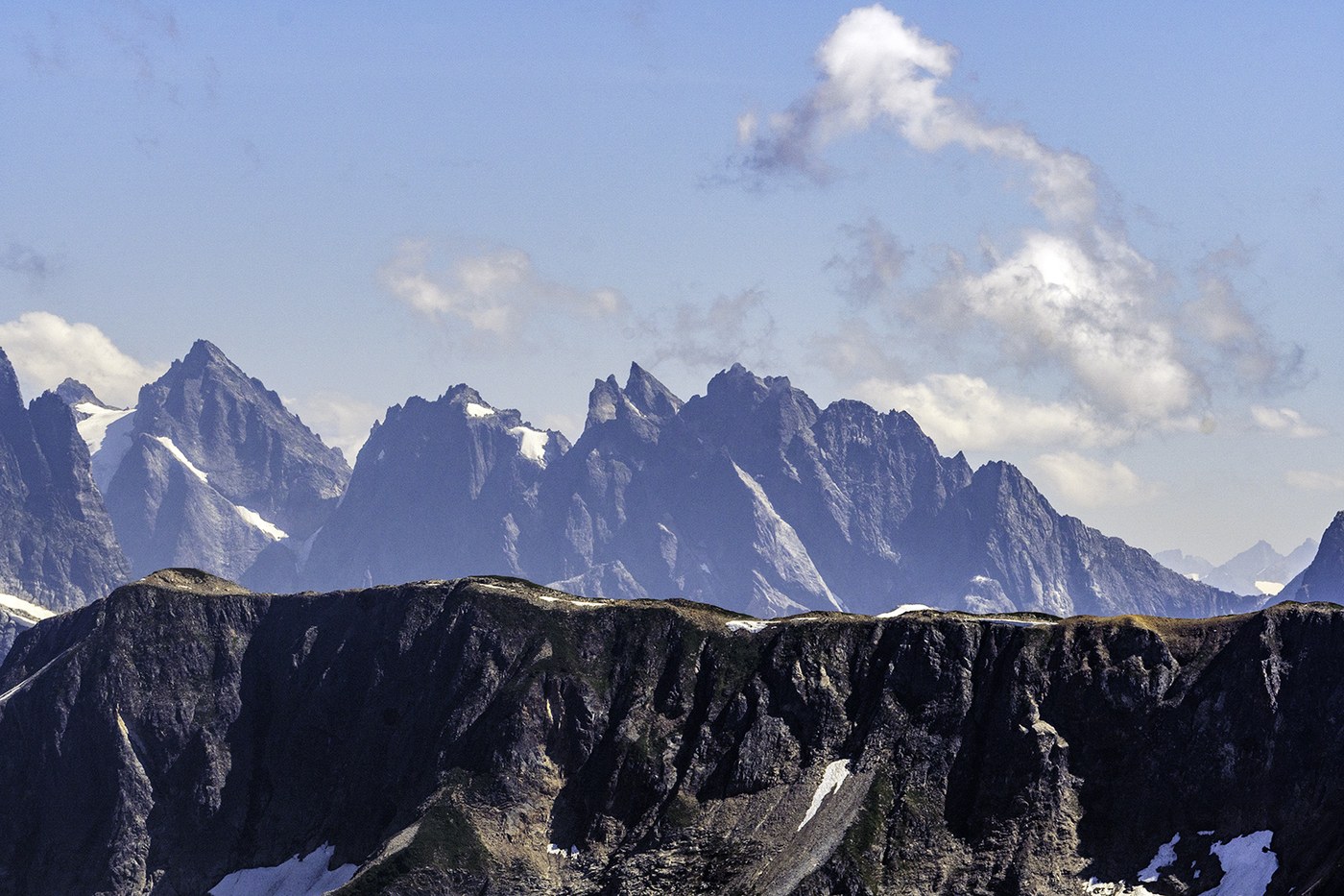
We headed out of the basin around noon, and off on the 1000' or so of gain to get to the lookout. The switchbacks are short and steep, and it never really lets up. You'll be high above the lake soon, and it is a beautiful view back down into the basin. The fog was gone by now, and there was a great breeze to make the sun somewhat tolerable. The views though. WOW. It's hard to make good time when you're stopping every minute to take a photo. Got to the lookout just before 2pm and had the entire area to ourselves (we met the ranger down by Copper Lake). The views here are just amazing. Peaks upon peaks upon peaks in every direction. We stayed for about an hour just taking in the views and enjoying the day.


I thought the trail to Silesia would be mostly downhill since the lookout is the high point of the trail, but I am dumb and that is false. There's downhill sections, and then plenty of uphill hiking to get there. My quads ACHE. We got to the turnoff around 4:30pm and got incredibly lucky by being the first group there (there are only 2 sites). The first one is the prime spot - it's large and has a GREAT view of the Pickets, Mineral Mountain, Whatcom Peak, Shuksan (though you need to walk around the corner), and half a view of Baker. The heather here is still going strong and lots of bees buzzing about.
With it being dry, we set up camp and then took our cookware and water bladders down the short and steep trail to Egg Lake. We ate our dinners down there and got all the water we'd need for the morning and the hike out the next day. Back up to camp in time for a fantastic sunset and some stars before promptly passing out.


- Site details:
- Water: Only available at Egg Lake - 1/2 mile and about 430' of elevation loss/gain
- Food Storage: Bear box
- Toilet: Composting toilet with a lid and a great view of Whatcom Peak
- Bugs: Thermacell died early in the evening and the mosquitos were terrible
Day 5 - 7.91 miles, 1424' gain, 3926' loss - Silesia to Hannegan Pass Trailhead: Woke up around 5:45am to catch the sunrise, and what a great one it was! Perfect time to get out of the tent and watch the pink sky hit all the peaks.


A quick breakfast and pack up we hit the trail for the final day at 8am. And the inclines still weren't over. COOL. LOVE IT. The trail was beautiful at least, and there was still a decent breeze.

The flies came back in force part way back up the switchbacks to Hannegan Pass, forcing us to keep moving. They were horrible at the top so we stood there for maybe a minute before starting the long descent back to the car. Flies eased off closer to the bottom, and a surprising amount of people heading up with backpacking gear for a Monday.


While it wasn't as hot as Thursday, there was only a light breeze so the valley was still incredibly hot. At least this time it was all downhill.


We got to the car around 1:30pm and hopped in the river for a refreshing cool down and to get some of the dirt off of us (there's a little trail opening by the road closure sign). Back in the car with fresh clothes on horrifically unfresh people, we made our way to Chair 9 for a stupid amount of fries, chicken wings, and beer.
Comments