
Pasayten - Billy Goat Corral to Park Pass area 8/13 -8/20/08
Short version: I spend 8 days with my 3 packgoats: Gobi, Prince and Zermatt exploring the Paysaten wilderness north of the Billy Goat Corral trailhead. The main trails are logged out and in good condition. From Larch Pass north, travel is mostly in meadows at about 7000 ft +/-. This is horse country. During the 8 days I saw 5 horse and 4 hiker parties, most on the first and last days, going from and to the TH. Several of the days I saw no one.
Longer version:
Day 1, Wednesday, August 13th – drove from Gig Harbor, through Winthrop, to the Billy Goat Corral trailhead. Started hiking at 2:30 pm. The access is via the Chewuch River road and then Eightmile Creek road north of Winthrop. Eightmile Creek road is paved part of the way then good gravel till the last couple of miles where it looks like it’s been graded recently but still has a few rough spots. It took the better part of an hour to get to the trailhead from Winthrop.
Unlike this week, last Wednesday was sunny and hot even at the 4800 ft. TH. The trail splits about 1/4 mile from the TH with one branch going over Billy Goat Pass, gaining 1,800 ft in about 2.7 miles; the other goes over Eightmile Pass, gaining 700 ft in about 1.8 miles. I had not been over Eightmile Pass before and the idea of a little less elevation gain on a hot afternoon made that choice more appealing, even though I knew that to get to Three Fools Pass would mean 2 more miles of trail (the next day) and only save about 400 ft of total elevation gain. The trail over Eightmile Pass has a gentle grade and is good condition. Travel is through small pine/mixed forest. That evening we camped at the crossing of Drake Creek, doing about 4 miles for the afternoon.
Day 2, Thursday – hiked up the Drake Creek trail to the junction with the trail coming over Billy Goat Pass. This section of trail was again gentle grade, good condition and small pine/mixed forest. Next it was north through Three Fools Pass (I’ll like to know the story behind that name!). It’s a mile long V shaped notch through the mountain, mostly rock, some meadow and a few small trees. Then it was down to the bridged crossing of Diamond Creek and the traverse around into the Larch Creek valley. Along one section of trail there were a few aspen trees in the talus slope, then back to the spindly small pine forest. At about 4.7 miles from the Drake Creek – Billy Goat Pass tail junction is the crossing of Larch Creek on a small bridge, with a camp site in a small meadow. The trail follows Larch creek upstream through a mix of meadow and woods (mostly woods); re-crosses the creek (rock hop); switchbacks a few times up a step in the valley; comes to a little larger meadow; then does the final couple of long switchbacks up to Larch pass at about 7100 ft. Here are the first views of the meadow country to the north…McCall Gulch and Ashnola Mountain with Whistler Pass.
We traversed about a mile into McCall Gulch and the junction with the East Fork Pasayten River trail. Part way across the traverse we met a wilderness ranger. She was on horseback and had a second pack horse for gear. She was very helpful with trail information. She said she was headed for the trailhead after being out for 7 days.
The East Fork Pasayten River trail junction is marked with a small sign and a couple of cairns leading across the meadow. Tread soon appears, crosses the creek and heads west. We soon left the trail and found a nice flat spot in the meadow south of Whistler Pass to camp. All of McCall Gulch is open tundra like country…mostly grass and small plants like wortleberry. Travel for the day – about 10.5 miles.
Day 3, Friday - We headed up across the meadow to pick up the trail through Whistler pass. Green Trails shows it as a dashed line starting at the 7500 ft pass at the head of McCall Gulch. Neither the NG Topo map or the FS Pasayten Wilderness maps show a trail there. Besides the branch that starts at the 7500 ft pass there is one that starts about half way up the McCall Gulch meadows which can be seen from Larch Creek trail #502. The two branches join on the slopes SE of Whistler Pass and traverse up through the pass. The trail then traverses north down into Whistler Basin. The trail then traverses north at about tree line along the west slopes of Sand Ridge. Even though it was mid August there were some really nice patches of wildflowers along this section.
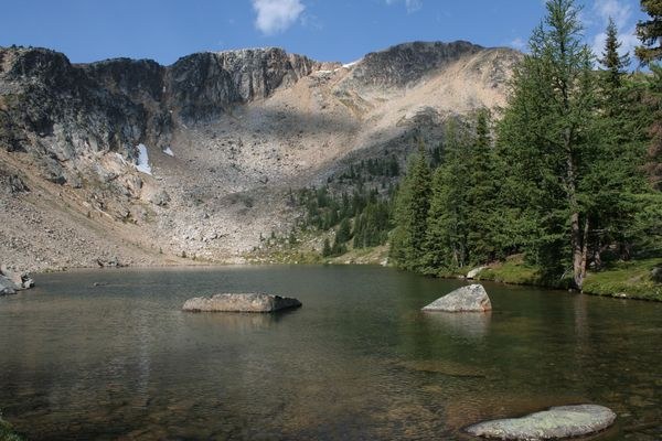
For not showing on the FS map, the trail was surprisingly good and easy to follow except for one short section coming down from the shoulder which extends west from Sand Ridge just south of the Boundary Trail. This was wide open meadow and easy traveling. It was not long until I spotted the tread below and followed it the last little bit to the Boundary Trail. I then headed west a little ways to the Quartz Lake trail junction and a ½ mile to the lake. I noticed a wilderness oddity - by the Boundary Trail – Quartz Lake trail junction…a very rusty but apparently functional old wheelbarrow leaning against a tree. Quartz Lake is a nice lake with several camp sites; I found a nice one for the night. The topo map shows a small lake in the next basin to the NW. In the afternoon I found a faint boot path and followed it to the second lake and found it to be shallow, really more like a large pond. Travel for the day – about 6.3 miles.
Day 4, Saturday – We went back to the Boundary Trail and headed west, traversing through the meadows of Quartz Mountain. Where the trail swings around to the north before dropping down to Dean Creek, there is a post by the trail and a couple small logs laying in the tread. There are a couple cairns leading up across the meadow, but no tread at first. Following the cairns is the correct way. A short distance further is a patch of wildflowers with a spring just below the trail…the only water since Quartz Lake. The trail then drops down through a recent burn area to a crossing of Dean Creek. Dean Creek was surprisingly good sized, since from the topo map it looks like the Boundary Trail crosses it almost at the ridge crest. Looking closely at the topo map I realized it must drain from a fairly good sized area on the north slope of Quartz Mountain. The trail then continues west over the 6671’ hump on the ridge, down a bit and then up toward Bunker Hill (mostly through burned forest) where it follows the ridge crest for about a mile. Bunker Hill does have a 360 degree view, but it was somewhat hazy and the more rugged peaks are some distance to the west. On top there are the 4 concrete footings of a former lookout. The broad meadows of Bunker Hill were dry tundra; or maybe it was because it was a pretty warm afternoon, but somehow, I did not find it all that enchanting.
We returned east along the Boundary Trail to the area on the west slope of Quartz Mountain and found a seldom used camp site in a clump of trees a little way below the spring. This spring and the crossing of Dean Creek were the only water on this part of the Boundary Trail. While Bunker Hill did not inspire me, I did really enjoy the two mile traverse from the Quartz lake junction through the meadows of Quartz Mountain. Travel for the day – about 11 miles.
Day 5, Sunday – We headed east along the Boundary Trail, past the Quartz Lake junction, along the north slopes of Sand Ridge, and down to Peeve Meadow. It was quite a large meadow area surrounded by trees, with a stream and at least one horse camp…complete with tent, pack horses and gear lockers…the owners apparently out riding for the day. A short distance up from the meadow is the junction with the Park Pass trail #506. Unlike the Larch Creek trail or Boundary Trail, this one does a lot of little ups and down to get around rocks and trees. When I asked the Forest Service about the trail’s status before the trip, they did not know; but said an outfitter often logs it out. There was one large tree down across the trail, but there was an easy way around it. Other than all the little ups and downs it was a good trail.
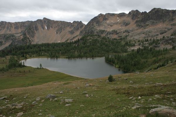
The area from Park pass to Ramon Lakes is very pretty green rolling meadow country with some very nice patches of wild flowers. As I was approaching the lakes I met 3 day hikers; turns out they were Canadian and had come over from their camp a Border Lake, a couple miles north in Canada. About then the sky turned dark, the thunder and lightening started, and the rain. It did not last long, but afterward, I could see 4 columns of smoke to the northeast. One was near the border clearing strip and small. One looked to be east of Cathedral Peak and became quite impressive. The smoke from it diminished as the wind died down near sunset. I found a nice camp spot among the Larches near the upper Ramon Lakes. The upper Ramon Lakes are pretty but quite shallow. Travel for the day – about 6 miles.
Day 6, Monday – Weather very different…mostly cloudy, cool, breezy with a few sprinkles. We went down to the larger Ramon Lake. This lake is quite a bit larger than the others, very pretty, but also fairly shallow. From there we headed down the trail toward Ramon creek, Martina Creek and Sheep Lake. Where the trail first leaves Ramon Lake there is no evident tread, but in a few hundred feet it appears and is easy to follow through the Ramon Creek valley and up the far (SE) shoulder. There it traverses down across open meadows on the east shoulder of Sheep Mountain. The tread fades away but there are cairns. This ‘trail’ heads for Martina Creek. I wanted to go to Sheep Lake first, so turned and started traversing south up across the meadows toward the shoulder which forms the north edge of the Martina Creek valley. Here I found the bits of tread which I had followed when it this area last fall. This leads up along the shoulder, through the meadows, appearing and disappearing until the last finger of meadow before the slopes get steeper heading up toward the summit of Sheep Mountain. There are sections of tread and a cairn leading down through the finger of meadow to… a well preserved log cabin complete with metal roof and hitching rails. From here there is a pretty evident horse trail which leads through the woods of upper Martina Creek valley and up to Sheep Lake…a very pretty spot. After a cool and quick swim, I headed back past the cabin, up to the meadow on the shoulder north of Martina creek and down along the shoulder…tread disappearing and the showing again a while later, as the meadow started to give way to more trees the tread became more defined and soon connected with the ‘trail’ from Ramon Lakes. From here the trail was well defined as in headed down to Martina creek, then follows Martina creek down stream to where it crosses the creek and connects to the Boundary Trail at a camp site. This section of trail from the meadows south east of Ramon Creek to the junction with the Boundary Trail does not show on the FS Pasayten wilderness map but does shows as a dashed line on my Green Trails map.
From the junction it was a steady climb back up, west, on the Boundary Trail through the spindly pine forests until the forest opens up into the meadows on south slope of Sheep Mountain. This area is pretty rolling green meadow country, but with only a fewer patches of wildflowers. After about 1 ½ miles the trail drops down to Peeve Pass and the junction with the north end of the Larch Creek trail #502. We headed south on the Larch Creek trail, through the meadows, on the east slopes of Sand Ridge and found a nice camp spot below the trail which looked like it had not been used for quite some years. I got the tent set up just before the rain showers started. Travel for the day – about 10 miles.
Day 7, Tuesday – Weather was more of the same…mostly cloudy, cool, and windy with a few sprinkles. We continued south through the meadows on the east slopes of Sand Ridge to the headwaters of Timber Wolf Creek. Just before the trail got up to the ridgeline heading up to the 7500’ pass/saddle to McCall Gulch there was a trail heading north which does not show on any of my maps. We followed it north, it soon crossed over the saddle to the Crow Lake – Gabril Creek basin and lazily wound its way down through the meadows to a large horse camp. There were a couple trails radiating from here. We followed one north which contoured around the basin to the NE and after a couple mile traverse reached the broad shoulder where shallow pond 7151’ is located. The broad shoulder is dry tundra like country with a few wildflower patches. We returned the same way to the upper Gabril Creek basin which I though was quite picturesque. We followed a trail across to Crow Lake which is fairly shallow and has a rather over used looking horse camp area near the outlet stream. There are some pretty spots near Crow Lake, but the horse camp area near the outlet is definitely not one of them.
From Crow Lake we followed a trail (not on any of my maps) through the meadows up to connect with the Larch Creek trail a little north of the 7500’ pass/saddle to McCall Gulch. At the pass is the signed junction with the trail to Corral Lake. It does a rising traverse across upper McCall Gulch basin, then switchbacks fairly steeply down into Corral Lake basin. Corral Lake is beautiful, set in a broad green, grassy basin with Larch trees scattered around. There are a number of nice camp sites scattered in the trees in the basin, back from the lake. I was thinking of camping there, but it was mid afternoon, cloudy, cold and windy. The weather forecast from Vancouver which I’d picked up on the radio the night before sounded like the weather was likely to get wetter, not better, so I decided to go back up to the Larch Creek trail and head south to Larch Pass. There is a side trail at the pass which angles off to the right (south) and goes about 1/3 mile to a couple nice camp spots among the larch and meadows. Again, I was fortunate to get the tent set up before the rains started. It rained pretty good off and on during the night. Travel for the day – about 11 miles.
Day 8, Wednesday, August 20th – I got camp broken down…mostly between showers, headed back to Larch Pass and south on the Larch Creek trail, over Three Fools Pass, and over Billy Goat Pass to the trailhead. It rained for the first couple of hours; then it was clouds, showers and a couple brief sun breaks. Travel for the day – about 13.5 miles.
There were some mosquitoes and flies which were a bother at times, but overall they were not bad.
Most of the country north of Larch Pass is around 7000 ft high; broad meadows with several nice lakes. In short, I had a great hike through beautiful country, which not many people see…certainly a far different experience than some of the popular west side trails!
Comments
Did this hike when I wad 16, planning to take my daughter for her 16th
Posted by:
Digbaddy1978 on Jan 12, 2019 09:42 PM
Are you aware that the Diamond Creek fire burned most of all of the area in 2017?
Posted by:
Perry on Jan 13, 2019 07:18 PM