Trails for everyone, forever

Home Go Hiking Hiking Guide Mount Adams Highline

Mount Adams Highline

South Cascades > Mount Adams Area
46.3095, -121.5429 Map & Directions
Length
22.2 miles, roundtrip
Elevation Gain
1,550 feet
Highest Point
7,750 feet
Calculated Difficulty About Calculated Difficulty
Hard
Mount Adams up close. Photo by trip reporter Trail Pair. Full-size image
  • Lakes
  • Mountain views
  • Wildflowers/Meadows

Parking Pass/Entry Fee

Northwest Forest Pass
Saved to My Backpack

Hike a challenging trail over steep and varied terrain to views of glaciers, mountains, and the remote northeast side of Mount Adams. Continue reading

Rating
3.88 out of 5

(8 votes) Log in to rate

Hiking Mount Adams Highline

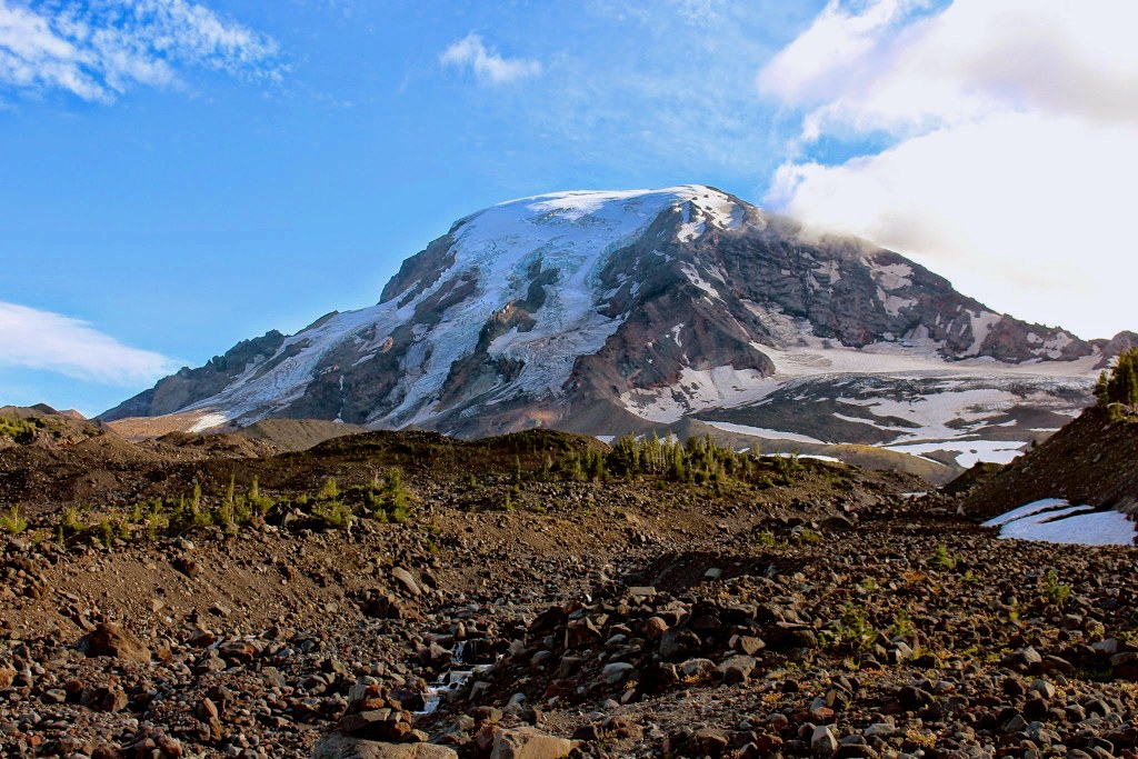
This hike climbs the north side of Mount Adams to spectacular alpine tundra and panoramic views on Devil's Garden via two challenging stream crossings. The garden is situated on a high plateau below the heavily-crevassed Lava and Lyman Glaciers.

High Line is connected to the Killen Creek Trail by the Pacific Crest Trail. Beginning on Killen Creek, hike north for 2.3 miles to a junction with the Pacific Crest Trail. Turn left, and follow the PCT for 0.6 miles to Killen Creek Camp on a challenging section of trail that goes up, down, and around in ways the terrain doesn't predict.

Another 0.1 miles past Killen Creek you'll find a junction with the PCT and Batty Lake. Take the right fork, and begin hiking on the High Line trail. You'll proceed 1.7 miles to a junction. Stay right, and continue 5.4 miles on High line trail. This is a steeply-climbing section of trail that takes you to the border of the Yakama Nation and is subject to closures. It also requires a separate permit, given out by the Yakama Nation.

Note: You'll cross two branches of the Muddy Fork River along the way, which can be difficult or dangerous if the water is high.

Toilet Information

  • No toilet at trailhead

More information about toilets

WTA worked here in 2023, 2012, 2011 and 2010!

Mount Adams Highline

Map & Directions

Trailhead
Co-ordinates: 46.3095, -121.5429 Open in Google Maps

Before You Go

See weather forecast

Parking Pass/Entry Fee

Northwest Forest Pass

WTA Pro Tip: Save a copy of our directions before you leave! App-based driving directions aren't always accurate and data connections may be unreliable as you drive to the trailhead.

Getting There

There are two routes to Killen Creek Trailhead, located on Forest Road 2329.

From I-5 / Highway 12

Drive Highway 12 west to the intersection with County Road 131. Turn right on 131 and continue to the fork where the road splits to become Forest Roads 23 and 25. At the fork, stay left to take Forest Road 23 and continue to drive south. Arrive at a junction with Forest Road 2329, marked with a sign for Takhlakh Lake and turn left on to Forest Road 2329. Drive past the campground, and it's about 4 miles to the trailhead. 

From Trout Lake

Travel east down the hill on Highway 141 to the V intersection with Mount Adams Road at the gas station. Turn left on to Mount Adams Road and continue to the fork in the road. Fork to the left, following the signs for Randle on to Forest Road 23.

Stay on Forest Road 23 to the intersection with Forest Road 90. At this intersection follow the signs, making a left then an immediate right to stay on Forest Road 23, and travel up to the intersection with Forest Raod 2329. Turn right on to Forest Road 2329. Drive past the campground 4 miles to the trailhead.

More Hike Details

Trailhead

South Cascades > Mount Adams Area

Highline (#114)

Gifford Pinchot National Forest, Mount Adams Ranger District

Guidebooks & Maps

100 Classic Hikes in Washington by Ira Spring and Harvey Manning

100 Hikes in Washington's South Cascades and Olympics by Ira Spring and Harvey Manning

Green Trails 367S Mt Adams

Green Trails 334 Blue Lake

Green Trails 335 Walupt Lake

Green Trails 366 Mount Adams West

Trails Illustrated Mount St. Helens Mount Adams

Buy the Green Trails Mt Adams No. 367S map

Buy the Green Trails Blue Lake No. 334 map

Buy the Green Trails Walupt Lake No. 335 map

Buy the Green Trails Mount Adams West No. 366 map

You can improve or add to this guidebook entry!

Mount Adams Highline

41 Trip Reports

Hiked here recently?

Submit a trip report!
 
Trip Reports