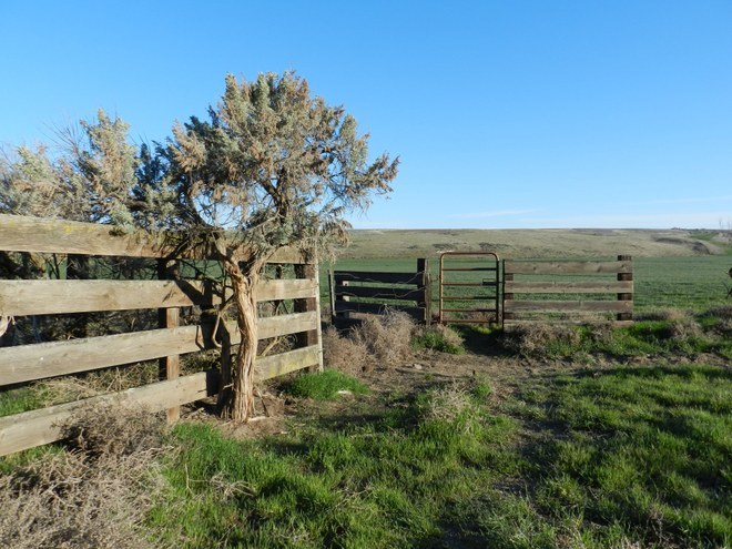

This BLM-managed wilderness area is unlike any other Washington wilderness. For one thing, the year-round access point is through an off-road OHV park, which visitors may need to hike through to reach the wilderness gate. For another, the whole of the 7,140-acre wilderness is enclosed by a fence. Old tire tracks that predate wilderness designation are still visible in some areas within the fence that keeps OHVs out, illustrating just how fragile this ecosystem is.
Although it's impossible to leave behind the sounds of the OHV park, inside the wilderness gate the landscape is drastically different. Near the southern end of the wilderness, native grasses are generally out-competing noxious weeds blown in on the wind, and the hills are gently undulating. The farther north one travels, the denser the vegetation generally becomes, and the hills become steeper. Grass gives way to low shrubs and tall sagebrush to the northwest, and Washington's largest remaining juniper groves dominate the north and northeast.
The wilderness is home to diverse wildlife, both common and rare. Tracks and scat will be the main indicator of the flourishing populations, but it is likely visitors will be able to at least catch a glimpse of the numerous deer and coyotes within the wilderness. The juniper berries attract a large population of birds, especially in winter when forage elsewhere is scarce. Rare animals that can be found here include sagebrush lizard, black-tailed jackrabbit, grasshopper mouse, kangaroo rat, ferruginous hawk, and Swainson's hawk.
When planning a trip to Juniper Dunes, keep in mind that the wilderness limit is 8 heartbeats. Know that an overnight permit is required for backpacking, available for free by contacting the BLM office in Spokane. Campfires are strictly prohibited, and visitors must be well-versed in Leave No Trace ethics. While dogs are not prohibited, the rugged nature of this area may mean it's best to keep dogs at home, or at least on a short leash. Many of the noxious weeds near the wilderness fence have thorns, and the southern portion of the wilderness area contains numerous beds of cacti. There are also no water sources within the wilderness area, so all water necessary for the trip must be carried in.
Hikers need to be well versed in map and compass navigation skills when visiting here. There are numerous game trails crisscrossing the wilderness, but no maintained hiking trails. Although the entire wilderness is fenced, and walking the boundary would total roughly 15 miles, a visitor would get little sense of the wild nature of this wilderness by sticking to the fence line.
With USGS maps and compass bearings, perhaps backed by GPS waypoints, the best way to really see this unique ecosystem is to strike off across the rugged center. While the difference between the highest point and lowest point of this wilderness amounts to approximately 300 feet, the rolling nature of the landscape means hikers will gain and lose elevation many times, and can easily lose sight of distant landmarks. Loose footing contributes to the more difficult nature of hiking here.
Juniper Dunes Wilderness

-
 Length
- 15.0 miles, roundtrip
-
 Elevation Gain
- 300 feet
-
 Highest Point
- 1,050 feet
Witness the polar opposites of land use management in this unique BLM wilderness, accessed through a popular OHV area. Once within the wilderness fence, visitors are rewarded with wide-open hiking through varied terrain, including the largest remaining juniper groves in Washington.
Continue reading
Hiking Juniper Dunes Wilderness
Map & Directions
 Trailhead
Before You Go
Parking Pass/Entry Fee
NoneWTA Pro Tip: Save a copy of our directions before you leave! App-based driving directions aren't always accurate and data connections may be unreliable as you drive to the trailhead.
Getting There
From Highway 395 near Pasco, travel east on US 12 to the junction with the Pasco-Kahlotus Highway. Turn north and travel 5.6 miles to Peterson Road (poorly marked, but with a crop duster airstrip, grain silo, and an extra-large yellow mailbox on the east side of the road). Turn west on Peterson Road, a rough, increasingly narrow and bumpy gravel road. Continue four miles to the first of the BLM kiosks within the OHV park and park in the open parking area approximately 100 yards beyond the kiosk if the ground is dry and the sand is soft. It is a 3.5 mile walk through the OHV area from here to the wilderness boundary.
For those in high clearance vehicles, and only during times of the year when the sand contains adequate moisture, it is possible to continue down the rough OHV main road. Watch for the poorly marked Wilderness Road on the right just before the road passes a natural gas pipeline and below the main electrical lines. A single green fence post with no signage marks the intersection. The Wilderness Road is little wider than a car and may be blocked in places by windblown tumbleweeds (easily cleared from the roadbed, but keep leather gloves in the car for this purpose as the weeds contain thorns).
There is a small parking area near the Wilderness Gate, access point for hikers entering the wilderness area.


