

The Napeequa River valley has been described as the Shangri-La of the Cascades. Looking upon it will leave one with a sense of awe and breathlessness, though the lack of oxygen might be from the fact that the Napeequa River is protected on all sides by steep walls and glaciated peaks requiring over 4,000 feet of elevation gain just for a view.
The challenges don’t end there though, for the valley is protected by deep snow much of the year, bridgeless rivers that are downright dangerous to cross when raging in the spring, and clouds of ravenous biting flies in the summer months. Together these have kept the Napeequa River a quiet place with few visitors.
The Napeequa River Trail begins far from any trailhead at a signed three-way junction where the Boulder Pass and Little Giant Pass trails meet at the Napeequa River ford. Approaching the Napeequa River Trail from any direction requires a strenuous hike.
From the east, the Napeequa River ford can be reached by an eight-mile hike with 4,300 feet of gain over Little Giant Pass. From the west, the Napeequa River ford is approached via Boulder Pass which requires a 12-mile hike with 4,250 feet of elevation gain.
Most who visit the Napeequa River do so as part of a multi-day backpacking trip to connect the Boulder Pass or Little Giant Pass trails, to the High Pass or Louis Creek high routes. From the Napeequa Ford junction the trail closely follows the river upstream as it meanders lazily along the smooth valley floor.
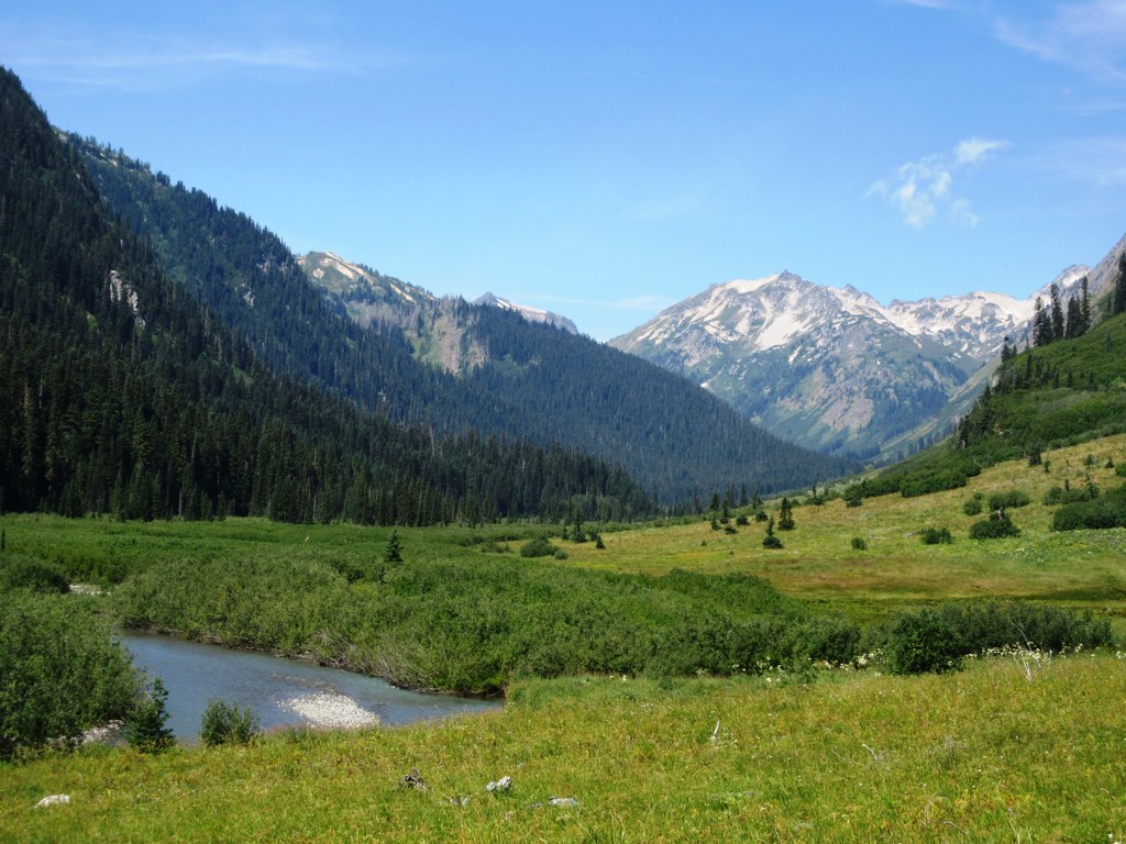
The way is generally flat and alternates between grassy meadows and dense slide alder. Views of the steep glacier carved walls of Chiwawa Ridge above you are contrasted by the rugged glaciated Clark Mountain Massif across the valley. At times the trail can be faint, washed out, and may be overgrown in the slide alder if not recently trimmed back. Push on and remain near the east side of the river and you’ll soon be through.
One and a half miles upvalley you’ll pass an excellent campsite just before crossing Louis Creek. Make time to enjoy the final plunge of Louis Creek toward the Napeequa River, and yes, many more falls hide out of view above for those willing to ascend the tangled slide alder along Louis Creek. At 2.7 miles the trail ends at a bend in the river where the bank has been eroded.
Look for pedestrian paths and patches of old tread to continue alongside the river (the trail does not cross the river and it's been a long time since it's been maintained) for another 0.1 miles until you arrive at the creek draining the large valley below High Pass. To ascend to High Pass, cross the creek and look for a cut branch that sometimes has flagging tied to it at the edge of the uphill trees about 50 yards north of the waterfall. Head directly uphill on a path that has been cut through the slide alder and thank the last person who brought a tool to clear it. For the truly adventurous, continue upstream and uphill along the Napeequa River to its headwaters in the valley below Butterfly Glacier.
WTA Pro Tip: The season to visit the Napeequa is short. By the time the snow melts and the river crossings are safe the biting flies will have emerged in force. September is the best time to visit and October can be pleasant. In either case, be aware of the hunting season and the forecast.
 Trailhead


