
Jutting 800 feet out of Banks Lake in Washington’s majestic coulee country, Steamboat Rock is the crown jewel of this area. The basalt butte has a rich history; first used by native people many years ago, and during the ice age, the Great Missoula Floods carved the canyons here, while the rock stood as an island in the raging river. Now, Steamboat Rock lies high and dry, offering excellent 360-degree panoramas of the landscape surrounding it.
The butte covers 600 acres and the trail that ascends from the base of the rock to the somewhat flat top affords hikers incredible views of the surrounding area after an initially steep and scree-y ascent. If you can get there for wildflowers, do so. There’s something surreal about strolling through a lush meadow of bobbing flowers 800 feet in the air. Even if you miss flower season, the views here are stunning at any time of year.
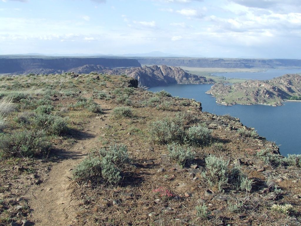
The rolling hills of the Colville National Forest back up the flat scablands to the north, the snow-capped peaks of the Okanogan-Wenatchee National Forest stand sentinel near Chelan to the west, and south, the waters of Banks Lake are picturesque in almost any weather. But first, you have to get up there.
There are several trails that feed into the main trail that approaches the base of Steamboat Rock. From the day use area or the campground, look for a sandy path just across the paved road that you drove on to get here. Jump on that sandy path and immediately begin walking towards the mighty rock through sagebrush and arrowleaf balsamroot. The sandy path can be a little tiring to walk on, but you’ll only be on it for a short while.
In less than a half-mile, arrive at the base of the rock. The trail is now comprised primarily of loose rock and scree while you climb up a draw between the cliffs. Watch your footing here and be mindful of other hikers near you.
After the short vertical ascent, arrive at a fork in the trail. Either way, you have just a little more elevation gain ahead of you, but the trail loops all the way around the plateau, so select either way — you’ll arrive back at this junction at the end of your hike. If you elect to head north, you’ll see Banks Lake and Grand Coulee below sheer cliffs. Those who have trouble with heights may want to note that the trail goes quite close to these cliffs before turning south and meandering through more rolling meadows.
If you take the left trail, get you’ll see more of Banks Lake and cliff walls to the east — the only direction that you don’t have miles of views. The trail to the south does get a little tricky to find, so be sure to have a map with you.
Thanks to a trail that cuts through the center of the rock, it is possible to do either the Northern Loop or the Southern Loop, depending on the time you have available. The northern section can be done as a three mile loop, and the second section is about 2.5 miles.
WTA Pro Tip: If you’re heading south after your hike, be sure to stop at Sun Lakes-Dry Falls State Park. The overlook is an impressive view of what used to be a giant waterfall during the Ice Age floods, and there’s an ice cream truck to refresh yourself.
Steamboat Rock

-
 Length
- 6.0 miles, roundtrip
-
 Elevation Gain
- 650 feet
-
 Highest Point
- 2,250 feet
Jutting 800 feet out of Banks Lake in Washington’s majestic coulee country, Steamboat Rock is the crown jewel of this area. The basalt butte has a rich history; first used by native people many years ago, and during the ice age, the Great Missoula Floods carved the canyons here, while the rock stood as an island in the raging river. Now, Steamboat Rock lies high and dry, offering excellent 360-degree panoramas of the landscape surrounding it.
Continue reading
Hiking Steamboat Rock
Map & Directions
 Trailhead
Before You Go
Parking Pass/Entry Fee
Discover PassWTA Pro Tip: Save a copy of our directions before you leave! App-based driving directions aren't always accurate and data connections may be unreliable as you drive to the trailhead.
Getting There
Head east on I-90 to exit 151 for Ephrata/Soap Lake. Drive through Ephrata to the junction with State Route 17 in Soap Lake. Continue on SR 17 through Soap Lake and continue 21 miles, turning right onto Hwy 2. Drive for 4.3 miles, then arrive at another junction, where you'll merge onto Hwy 155. About fifteen miles from the Y junction, turn left onto Steamboat Rock Park Entrance Road. You'll be heading out on a peninsula that juts into Banks Lake. Proceed through the entrance station, and begin looking for the day use parking area, on the right shortly after the entrance station. Discover Pass required.


