Trip Report
Hex Mountain Snowshoe — Saturday, Jan. 21, 2017
 Snoqualmie Region > Salmon La Sac/Teanaway

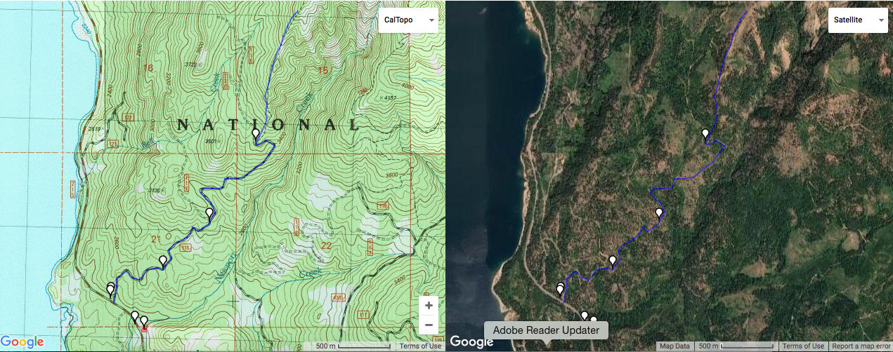
This was my first time on the trail and I went part way up the old 1343 trail. It was a bit challenging to figure out where a lot of the pictures and waypoints previous posters actually were on the route and the map, so I wanted to put some maps here to help other first-timers.
In reference to the attached main map (Hex Mtn Map), the white dots / flags going from the bottom (South) to the top of the page (North) are the following points:
1. Firehouse at 11.2 miles from roundabout where Bullfrog Rd meets 903 and you take 903 north / Salmon La Sac rd. The firehouse will be on your right in the direction you are going (North) and just before a small brown sign saying "Newport Creek".
2. On the left side of the road across from the firehouse is the single car parking.
3. (Note: I had trouble with waypoints so it looks like there are two on top of each other here). To get to the start of FS 116 (the main logging road), walk North on Salmon La Sac road about 200 ft to the first maintained / plowed road going off to the right. It is the second road on the right after the Newport Creek sign and has big orange signs saying "Logging Trucks Only".
4. Location of the old road grader with the "Hey Boys" sign scrawled into it. As previous posters mentioned, you actually need to stay on the main logging road here.
5. Turnoff to unmaintained, old logging road after a small turnout with single pine tree.
6. Turnoff to the summer trail at sign "Hex Mountain Trail 1343".
I've also included a pdf version that has some of this written on it. FYI - I found it really helpful to bring my phone and navigate using google maps satellite overlay to be compare where I actually was with the various possible logging roads / spurs. Also, since I was the first one up the summer trail and I had never been, I just followed the ridge line since that is what is shown on the topo maps.


Comments
Your detailed and accurate maps / descriptions were incredibly helpful to me today, so I just want to THANK YOU for the time you took writing this trip report!
Posted by:
knnyquist on Feb 12, 2017 09:04 PM