Trails for everyone, forever

Home Go Hiking Hiking Guide Amon Basin Natural Preserve
link

Amon Basin Natural Preserve

Central Washington > Tri-Cities
46.2152, -119.2540 Map & Directions
Length
1.9 miles, roundtrip
Elevation Gain
79 feet
Highest Point
548 feet
Calculated Difficulty About Calculated Difficulty
Easy
Amon Basin wetlands. Photo by Mary Hartman. Full-size image
  • Dogs allowed on leash
  • Good for kids
  • Rivers
  • Wildflowers/Meadows
  • Wildlife

Parking Pass/Entry Fee

None
Saved to My Backpack

Stroll in a peaceful slice of nature tucked into south Richland, enjoying old-growth sagebrush, wildflowers, willows, and cattails. Bring your binoculars to watch birds and riparian wildlife. Continue reading

Rating
0.00 out of 5

(0 votes) Log in to rate

Hiking Amon Basin Natural Preserve

Amon Creek Natural Preserve represents a triumph of conservation over development for 75 acres of riparian habitat along Amon Creek, the largest tributary of the lower Yakima River. The hiking route described here traverses the upper rim of the basin first, and returns via a lower path along the creek. Do note this area has ticks — be sure to check after your hike.

The trailhead is at the west end of the Claybell Park parking lot, marked with a “trail access” sign and another sign about local wildlife. The wide, crushed gravel trail curves to the left. At 0.2 mile you come to a trail junction. Take the dirt trail that continues southward.

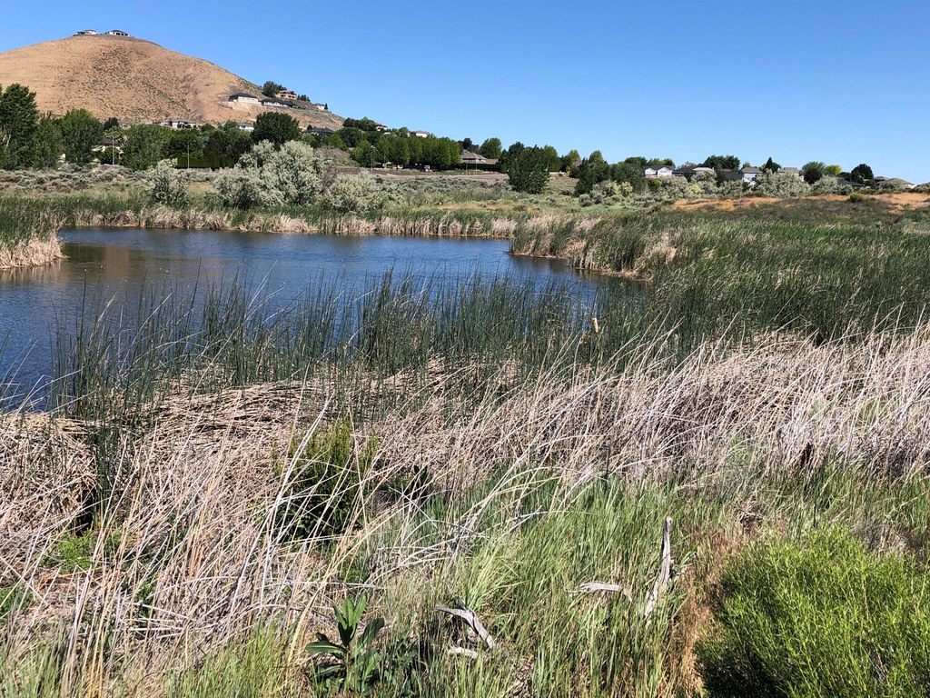
There’s a wire fence on your right, protecting the Tapteal Greenway Association’s restoration efforts. After another 0.1 mile you come to a pumphouse and settling basin. Take the dirt track to the left of the basin. This route gives you beautiful views of the wetlands and creek below you. You’ll soon come to another  junction; keep left to stay on the higher route. The trail eventually meets a gravel service road (which leads to the alternative trailhead off Leslie Road). Turn right on the gravel road, and just before a bridge over the  creek you’ll see another “Trail Access” sign on your right.

Take this narrow dirt trail, which is adjacent to the wetlands. Where the trail climbs a small hill and joins other pathways, turn left and continue along the creek, pausing to enjoy one of the two wildlife viewing platforms if you wish. The trail eventually reconnects with your previous route, and you can proceed back to Claybell Park.

History

The City of Richland and the Tapteal Greenway Association (a non-profit conservation group) partnered to create this preserve amid a rapidly growing south Richland neighborhood. Although the preserve is surrounded by housing developments, it encompasses native wetland, riparian and shrub-steppe habitats for birds and other wildlife, including rabbits, beavers, mink, and muskrats. Hiking and biking opportunities in Amon Creek Natural Preserve include 3 to 4 miles of gravel roads and dirt trails.

Toilet Information

  • Toilet at trailhead
  • Accessible toilet

More information about toilets

Hike Description Written by
Mary Hartman, WTA Correspondent

Amon Basin Natural Preserve

Map & Directions

Trailhead
Co-ordinates: 46.2152, -119.2540 Open in Google Maps

Before You Go

See weather forecast

Parking Pass/Entry Fee

None

WTA Pro Tip: Save a copy of our directions before you leave! App-based driving directions aren't always accurate and data connections may be unreliable as you drive to the trailhead.

Getting There

From Washington Highway 240, exit to Columbia Park Trail and drive west 0.6 mile and turn left (south) on Leslie Road. Drive 1.9 miles and turn left on Broadmoor Street. Proceed 0.6 mile to reach Claybell Park and turn right on Bellerive Drive to the parking lot by the soccer and baseball fields. It’s a big lot, but if it’s full of sports families, you can park on the shoulder of Bellerive Drive.

From I-182, take exit 3 for Queensgate Drive and turn south. At the traffic circle, take the 2nd exit and stay on Queensgate. In a quarter mile, turn left onto Keene Road. Drive 2.3 miles and turn left onto Gage Blvd, right on Leslie Road, then follow the directions above.

A second trailhead is located just off Leslie Road, about a mile south of Broadmoor Street.

More Hike Details

Trailhead

Central Washington > Tri-Cities

Richland City Parks

Guidebooks & Maps

https://tapteal.org/parks-preserves/amon-creek-natural-preserve/

Day Hiking Eastern Washington (Landers and Romano, The Mountaineers)

USGS Badger Mountain

DNR Richland

You can improve or add to this guidebook entry!

Amon Basin Natural Preserve

1 Trip Report

Hiked here recently?

Submit a trip report!
 
Loading trip reports...
Trip Reports