Trails for everyone, forever

Home Go Hiking Hiking Guide Burnt Mountain

Burnt Mountain

South Cascades > White Pass/Cowlitz River Valley
46.7152, -121.1660 Map & Directions
Length
5.0 miles, roundtrip
Elevation Gain
1,000 feet
Highest Point
6,500 feet
Calculated Difficulty About Calculated Difficulty
Moderate
Gathering clouds. Photo by Slugman.
  • Dogs allowed on leash
  • Mountain views
  • Ridges/passes
  • Summits
  • Wildflowers/Meadows
  • Wildlife

Parking Pass/Entry Fee

Northwest Forest Pass
Saved to My Backpack

This short, easy ridge walk climbs to a small summit with huge Cascade views and a chance to see mountain goats. Continue reading

Rating
4.14 out of 5

(14 votes) Log in to rate

Hiking Burnt Mountain

This short, easy ridge walk climbs to a small summit with huge Cascade views and a chance to see mountain goats.

Start on the Ironstone Mountain Trail, passing the William O. Douglas Wilderness sign to an open bluff with good views. From here, switchback down to the right a couple hundred feet and then traverse just below the ridge line for 0.25 miles before climbing slightly to the ridge top and an open area full of boulders and sagebrush. Just beyond is a junction with the Burnt Mountain Trail.

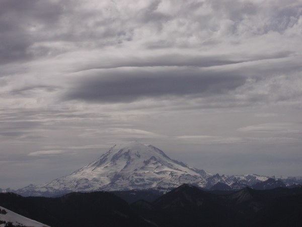
Keep left on the Ironstone, traversing a steep slope to a saddle with a nice view of Mount Rainier. The trail descends to a broad, wooded saddle and then begins climbing up the slopes of Burnt Mountain. The way is steep and forested, but after about 0.5 miles the trail breaks out of the forest and traverses below Burnt Mountain to a saddle on a south-trending ridge.

At this point, follow a boot path about 100 yards to the rocky summit and enjoy the view: south to Mount Adams and the Goat Rocks; west to Shellrock Peak and Mount Rainier; north to Bismark Peak, Nelson Ridge and Mount Aix; and off to the northeast, the Stuart Range. Watch for mountain goats on the steep slopes below. When you’ve had your fill, return the way you came.

WTA Pro Tip: This area is popular with hunters during the fall hunting season, so wear bright colors to make yourself visible.

extend your hike

If you're hoping for a longer adventure, the Ironstone Mountain Trail continues past Burnt Mountain, taking hikers to Ironstone Mountain and McNeil Peak, and eventually connects to the Rattlesnake Trail

WTA worked here in 2024 and 2023!

Hike Description Written by
David Hagen, WTA Correspondent

Burnt Mountain

Map & Directions

Trailhead
Co-ordinates: 46.7152, -121.1660 Open in Google Maps

Before You Go

See weather forecast

Parking Pass/Entry Fee

Northwest Forest Pass

WTA Pro Tip: Save a copy of our directions before you leave! App-based driving directions aren't always accurate and data connections may be unreliable as you drive to the trailhead.

Getting There

From Yakima, drive west on Highway 12 for 30 miles. Just past Hause Creek CG, turn right on Bethel Ridge Road. Once on top of the ridge, turn left on FR 199 (signed Cash Prairie) and drive 2 miles to the trailhead at the end of the road.

More Hike Details

Trailhead

South Cascades > White Pass/Cowlitz River Valley

Okanogan-Wenatchee National Forest, Naches Ranger District

Guidebooks & Maps

Day Hiking: South Cascades (Nelson & Bauer—Mountaineers Books)

Green Trails No. 303 White Pass

No. 304 Rimrock

You can improve or add to this guidebook entry!

Burnt Mountain

85 Trip Reports

Hiked here recently?

Submit a trip report!
 
Trip Reports