Trails for everyone, forever

Home Go Hiking Hiking Guide Cora Lake via Big Creek Trail

Alert: On Oct. 1 the federal government began a partial shutdown that will impact National Parks, National Wildlife Refuges and U.S. Forest Service lands in Washington. Here's the latest information we have for hikers and campers


Cora Lake via Big Creek Trail

South Cascades > White Pass/Cowlitz River Valley
46.6952, -121.8866 Map & Directions
Length
3.5 miles, roundtrip
Elevation Gain
1,170 feet
Highest Point
4,600 feet
Calculated Difficulty About Calculated Difficulty
Moderate
Cora Lake on a quiet day. Photo by racheljlp. Full-size image
  • Dogs allowed on leash
  • Fall foliage
  • Lakes
  • Mountain views
  • Old growth
  • Ridges/passes
  • Rivers
  • Waterfalls
  • Wildlife

Parking Pass/Entry Fee

None
Saved to My Backpack

With an average gradient of 13%, Big Creek Trail (#252) to Cora Lake — and beyond! — is a workout for some hikers despite its modest length, but it’s well worth the effort. You’ll be rewarded with waterfalls, a placid lake, enormous old trees and sweeping views of the surrounding cliffs and Mount Rainier. Continue reading

Rating
4.10 out of 5

(10 votes) Log in to rate

Hiking Cora Lake via Big Creek Trail

The trail begins at Forest Road 8420 and climbs steeply to Cora Falls and Cora Lake. It then continues to climb, passes a junction with the Teeley Creek Trail (#251), reaches a high saddle, and descends steeply to its terminus on Forest Road 8440. You can make a relatively easy hike to the lake and back (1.2 miles, 560 feet of elevation gain), do the whole thing (4.5 miles, 2,100 feet of elevation gain), or — as described here — get the best of both worlds and hike as far as the saddle for a fantastic view without the extra vertical descent/ascent (3.5 miles, 1,170 feet of elevation gain).

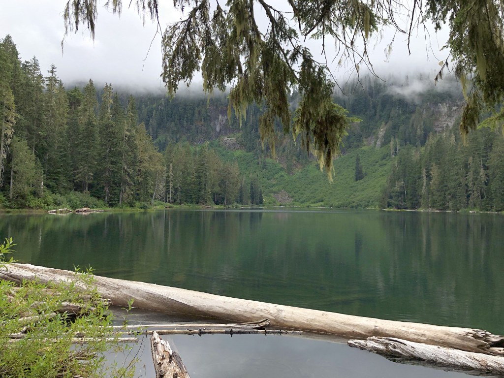
In the first half mile, the trail crosses Big Creek twice between different parts of Cora Falls. These are easy crossings when the water level is low, but could be tricky early in the season. After another half mile, you’ll reach placid Cora Lake, which you can access via a short spur trail. It makes a nice spot for setting up camp or just taking a break. High Rock lookout towers over Cora Lake, with its white fire lookout cabin visible on clear days.

The main trail continues uphill past the lake, and, in another 0.4 mile, it passes a junction with the Teeley Creek trail. Make a sharp left to stay on Big Creek Trail (#252). It continues to ascend through dense forest before opening up with a splendid view of towering cliffs to the north, Mount Rainier to the northeast, and Cora Lake below. Sit down and have a well-earned rest before you head back to your car.

WTA Pro-Tip #1: Cora Lake is stocked with trout; try your luck if you like to fish.

WTA Pro-Tip #2: Amazingly, some people ride motorbikes on this trail! If you hear them coming, better step aside.

Toilet Information

  • No toilet at trailhead

More information about toilets

Hike Description Written by
Mary Hartman, WTA Correspondent

Cora Lake via Big Creek Trail

Map & Directions

Trailhead
Co-ordinates: 46.6952, -121.8866 Open in Google Maps

Before You Go

See weather forecast

Parking Pass/Entry Fee

None

WTA Pro Tip: Save a copy of our directions before you leave! App-based driving directions aren't always accurate and data connections may be unreliable as you drive to the trailhead.

Getting There

From the west

The small town of Elbe is at the intersection of WA 7 and WA 706. Drive east on WA 706 about 10 miles and turn right on Kemahan Road E. This road turns left (east) and becomes Skate Creek Road (paved). Drive about 3.3 miles on and turn right on FR 84, a potholed gravel road that’s passable in a sedan if driven with care. Drive 4.4 miles and turn right on FR 8420, which is narrower than FR 84, but not as full of holes. Follow FR 8420 for 1.6 miles to the trailhead. There’s a small pullout just before the trailhead (room for ~5 cars), and room for a few cars near the trailhead along the wide spot in the road. The trailhead is on the left.

From the east

From Packwood, follow Skate Creek Road (FR 52; paved but potholed) north for 18.2 miles and turn left on Forest Road 84 and follow the directions above.

More Hike Details

Trailhead

South Cascades > White Pass/Cowlitz River Valley

Cora Lake (#251)

Gifford Pinchot National Forest, Cowlitz Valley Ranger District

Guidebooks & Maps

USGS Sawtooth Ridge

You can improve or add to this guidebook entry!

Cora Lake via Big Creek Trail

78 Trip Reports

Hiked here recently?

Submit a trip report!
 
Trip Reports