
If you don’t have the time or the inclination for the longer hike to Owyhigh Lakes, you can take a bite off the bigger trail and zip down about half a mile to see the charming 62-foot tiered falls of Deer Creek and a pair of footbridges traversing creeks flanked by a dense old forest.
Since there is no sign that designates Deer Creek Falls trail, you will access it via the “Owyhigh Lakes Trail” which is marked on the right of southbound Highway 123, across the street from the parking area. Quickly cross the road (watch for traffic, it’s a busy road on a blind corner) to the marker and you will finally see the trailhead, which is mostly invisible from the road due to brush and low hanging tree branches.
The trail immediately descends and disappears from the road into the forest valley. The descent is quick, but not too steep, about 280 feet over 0.4 miles. Wander down and around the couple of well-maintained switchback paths and marvel at the ancient and enormous Douglas fir trees, as well as the hemlock and cedar trees that thrive in the shadow of Mount Rainier. Be sure to note the curious 4-to-6 inch pine cones littering the forest floor and look something like a fat mice.
A quarter of a mile down is the first viewpoint of the falls. The falls are not huge, and the volume of water will vary depending on the time of year, but check out the cut of the boulders that make the water path appear to flow almost horizontally before pouring down to the next tier.
The trail continues another quarter of a mile which will provide another falls vantage point where you can see it tumble into the Chinook creek. This section of the trail ends at the Eastside trail junction. Deer Creek Camp is nearby (but out of sight, you may have to hunt for it if you're planning on camping). It offers a few simple walk-in only campsites and a pair of footbridges crossing over small but lively creeks that provide a place for rest, contemplation, or a least a few photo ops.
If you want to keep hiking, you have some options of varying lengths. You can continue another 1.5 miles to investigate another waterfall on Kotsuck Creek. Owyhigh Lakes is another 2.5 miles beyond that (about five miles from the trailhead), and Sunrise Road is an even further destination (about 10 miles from the trailhead). Otherwise, you can turn around at the footbridge and head back up to your car to complete this lovely one mile roundtrip leg-stretcher.
WTA Pro Tip: If you plan on camping on this trail please check with the rangers for conditions, permits, and regulations before packing your stuff in. You can also visit the National Park Service Mount Rainier webpage to plan your trip. No pass is required if you are just day-hiking or passing through.
Deer Creek Falls

-
 Length
- 1.0 miles, roundtrip
-
 Elevation Gain
- 280 feet
-
 Highest Point
- 3,200 feet
SR 123 (Cayuse Pass) is closed between the junction with Stevens Canyon Road and the junction with SR 410 for the winter season.
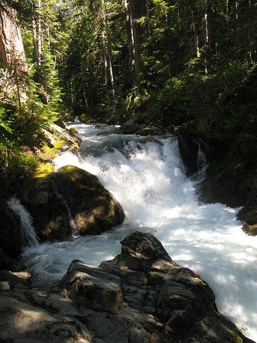
If you don’t have the time or the inclination for the longer hike to Owyhigh Lakes, you can take a bite off the bigger trail and zip down about half a mile to see the charming 62-foot tiered falls of Deer Creek and a pair of footbridges traversing creeks flanked by a dense old forest.
Continue reading
Parking Pass/Entry Fee
NoneHiking Deer Creek Falls
Map & Directions
 Trailhead
Before You Go
SR 123 (Cayuse Pass) is closed between the junction with Stevens Canyon Road and the junction with SR 410 for the winter season.
Parking Pass/Entry Fee
NoneWTA Pro Tip: Save a copy of our directions before you leave! App-based driving directions aren't always accurate and data connections may be unreliable as you drive to the trailhead.
Getting There
From Enumclaw take Highway 410 about 47 miles east to the SR 123 junction where you will veer right into the valley. Access the Deer Creek Falls trail via the Owyhigh Trailhead marker 4.8 miles south. The trailhead is on the right and the small parking area is on the left. It is really a wide spot off the road, big enough for approximately seven or eight moderately sized vehicles.


