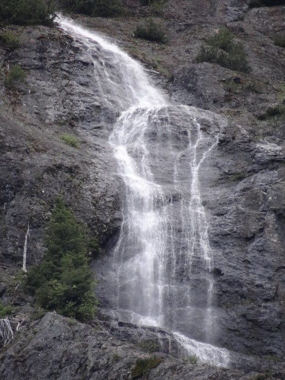
Trails for everyone, forever

Home Go Hiking Hiking Guide Denman Falls

Denman Falls

Mount Rainier Area > SW - Longmire/Paradise
46.7354, -121.8566 Map & Directions
Length
15.5 miles, roundtrip
Denman Falls. Photo by 1BLESSED3X. Full-size image
Saved to My Backpack

A little-known, yet spectacular waterfall, Denman Falls offers a relatively easy hike to it, if you can bear the 7.25 mile approach. Continue reading

  • Waterfalls

Parking Pass/Entry Fee

National Park Pass
Rating
0.00 out of 5

(0 votes) Log in to rate

Hiking Denman Falls

A little-known, yet spectacular waterfall, Denman Falls offers a relatively easy hike to it, if you can bear the 7.25 mile approach.

Because of the West Side Road closure, the short 150 feet to the waterfall must be completed only after a 7.5 mile hike or bike ride along the West Side Road.

After traveling the road, take a small spur trail just before the St. Andrews Creek bridge to beautiful, remote Denman Falls, named for the photographer who immortalized Mount Rainier National Park in the early part of the 20th century.

Denman Falls

Map & Directions

Trailhead
Co-ordinates: 46.7354, -121.8566 Open in Google Maps

Before You Go

See weather forecast

Parking Pass/Entry Fee

National Park Pass

WTA Pro Tip: Save a copy of our directions before you leave! App-based driving directions aren't always accurate and data connections may be unreliable as you drive to the trailhead.

Getting There

From the Nisqually Entrance, head up the Westside road to the gate. From here, it is nearly 8 miles to St. Andrews Creek. From St. Andrews Creek, the Denman Falls trail takes off to the right of the St. Andrews Creek bridge, leading hikers to the falls in about 1/4 mile.

More Hike Details

Trailhead

Mount Rainier Area > SW - Longmire/Paradise

Mount Rainier National Park

You can improve or add to this guidebook entry!

Denman Falls

5 Trip Reports

Hiked here recently?

Submit a trip report!
 
Trip Reports