

One of many Dry Creek trails in Washington State, this calf-burner located in the Cowlitz River drainage below White Pass zigzags you through young forest to the abandoned Smith Point fire lookout site and views of the surrounding mountains. If you are lucky you may even be able to spot Tahoma (Mount Rainier) on the horizon with a clear day!
Starting out innocently enough through vanilla leaf, Columbia windflower and sword ferns, this verdant trail soon comes to a crossing of the misnamed Dry Creek within 350 feet from your car. A straight approach is best for horses and bikes but a detour to the left takes you to an eroding log bridge spanning this mossy rock littered creek.
On the other side, the trail continues briefly to the right. A junction at 0.15 miles offers another sign for Dry Creek on the left and here is where your ascent begins on a set of switchbacks that follow a forested ridge to the southeast above the Dry Creek drainage. This lanky forest offers a low layer of underbrush which allows sunlight to gently filter in and illuminate the contour of the slope you are navigating.
A quarter-mile in, there is a trail to the right. Keep left. Along Dry Creek as you continue to climb through hemlock, alder and salal. In the early season, you may have your first glimpse of wildflowers such as fairy slippers or candy stick and huckleberries will delight those who venture up later in the heat of summer. Trenched switchbacks are a reminder you may share the trail with a few mountain bikes or stock as you slowly gain elevation.
A viewpoint to the right is possible at 2 miles when a break in the trees presents itself. On a perch dotted with bear grass, you can see Tahoma (Mount Rainer) rise above in the distance over Chutla, Wahpenayo and Unicorn Peaks. From here the trail takes a southern tack and continues towards a small knob that is your destination.
A more gradual pace begins around the knob's contour at 2.75 miles and leads to a saddle at 3.4 miles. Here the trail splits. To continue straight will eventually have you at Burton Meadows and Dry Creek Pass on an unmaintained trail but a sharp turn left and up on a few more switchbacks lands you at the leveled summit in a quarter mile for a total of 3.7 miles.
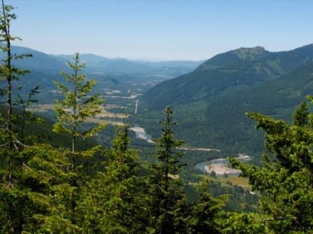
All that is left of the lookout are the cement footings, a few pieces of rusted hardware and remains of a stone structure tucked back in the trees. Hardy evergreens obscure what must have been at one point quite the panorama, now the best views are west down the Cowlitz River valley and across at Goat Pike and Winters Mountain. Bring a lunch and enjoy some time at this lofty location, you will most likely have it to yourself.
 Trailhead


