Trails for everyone, forever

Home Go Hiking Hiking Guide Evans Lake

Evans Lake

Central Cascades > Stevens Pass - West
47.6589, -121.3230 Map & Directions
Length
1.0 miles, roundtrip
Elevation Gain
50 feet
Highest Point
3,700 feet
Calculated Difficulty About Calculated Difficulty
Easy
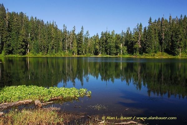
Evans Lake. Photo by Alan Bauer.
  • Dogs allowed on leash
  • Old growth
  • Good for kids
  • Wildlife
Saved to My Backpack

While Evans Lake may be less well-known than many of the other lakes nestled within the Alpine Lakes Wilderness, it nevertheless offers a pleasant backcountry experience. Continue reading

Rating
3.00 out of 5

(4 votes) Log in to rate

Hiking Evans Lake

From the trailhead, a straightforward and fairly level path leads directly to this pretty lake’s northern shore.  Following the lake’s outlet stream, the wide trail passes through an old-growth forest of Hemlock, Douglas fir and silver fir.  

Once at the lake, an overgrown and unmaintained boot path partially circles the lake to the right with a few downed trees to scramble over.  At the lake’s inlet stream, there are two campsites.  It is important to note that  campfires are allowed at Evans Lake, which is a rarity within the Alpine Lakes Wilderness.  

Although the trail is typically accessible by late spring, a visit in late summer or early fall offers a few perks including abundant huckleberries ripe for the picking and fewer mosquitoes and flies.  The 11-acre lake is known for quality fishing, and it is not uncommon to see fish jumping in the lake or anglers out on the water using packable watercrafts.

With its short distance, minimal elevation gain and low usage, Evans Lake is perfect for introducing small children to the wilderness, embarking on a first-time backpacking experience or simply getting out in the mountains for the day. 

After your hike, stop by LouSki’s Deli or Sky River Coffee in Skykomish for a post-hike sandwich or a warm beverage and pastry.

Hike Description Written by
Lindsay Leffelman, WTA Correspondent

Evans Lake

Map & Directions

Trailhead
Co-ordinates: 47.6589, -121.3230 Open in Google Maps

Before You Go

See weather forecast

WTA Pro Tip: Save a copy of our directions before you leave! App-based driving directions aren't always accurate and data connections may be unreliable as you drive to the trailhead.

Getting There

From Monroe, take US Highway 2 east to mile marker 50.5, just east of the Skykomish Ranger Station. Turn south onto Foss River Road (Forest Service Road 68). Continue on FS 68, staying to the right at the junction with FS 6835. Drive 3.5 miles beyond that junction, then turn left onto FS 6846.  Continue 2 miles to the trailhead on the right side of the road.

More Hike Details

Trailhead

Central Cascades > Stevens Pass - West

Evans Lake (#704.2)

Mt. Baker-Snoqualmie National Forest, Skykomish Ranger District

Guidebooks & Maps

Green Trails Skykomish No. 175

You can improve or add to this guidebook entry!

Evans Lake

21 Trip Reports

Hiked here recently?

Submit a trip report!
 
Trip Reports