

Visit a forested basin with a small lake and extensive marsh created by a pyroclastic flows from Mount St. Helens 300-500 years ago that blocked the flow of Coldsprings Creek. The 1980 eruption sent renewed flows down the Coldsprings drainage which have impacted the trail.
Goat Marsh Research Natural Area was established in 1974 to represent a mosaic of mountain marshlands, swamps, and ponds and a xeric lodgepole pine forest characteristic of mudflow and glacial outwash around Cascadian volcanoes. The center of the 1,300-acre RNA contains a wetland while the eastern portion contain marshes dominated by grasses and sedges. Lodgepole pine dominates pyroclastic flow forests in the harshest areas while Douglas-fir and western hemlock dominate areas with richer soils.
Goat Marsh RNA contains many of the largest and tallest remaining specimens of noble fir, including the "Goat Marsh Giant" (272 ft height, 8.3 ft diameter at breast height, 4,430 cubic feet volume) and "Riker!" (253 ft height, 7.3 ft diameter at breast height, 3,810 cubic feet volume). This forest also contains Douglas-fir trees measured at over 300 feet in height.
From the small, obscure trailhead, hike downhill along a closed road through lodgepole pine forest. In winter, this is the Kalama Ski Trail. Stay on the Kalama Ski Trail as it veers to the left off of the old roadbed and crosses a dry drainage at 0.2 miles. Climb up the opposite slope out of the drainage and find a trail junction at 0.3 miles.
Turn right onto the Goat Marsh Trail, continuing on pumice soils through lodgepole pine forest. Reach the entrance to the Goat Marsh Research Natural Area, marked by a wood fence and sign, in 0.5 mile. By now, the forest has transitioned to Douglas-fir and western hemlock.
Follow the wide trail over a small rise, admiring the large trees. Goat Marsh comes into view through the trees to your right.
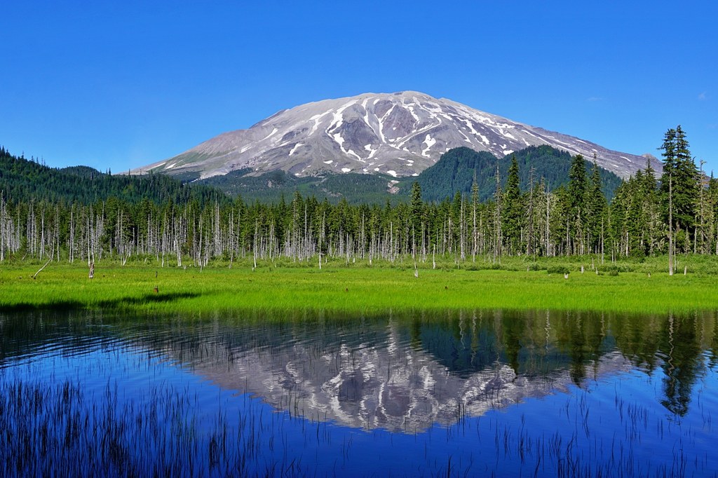
In 0.5 mile after entering the Research Natural Area, reach Goat Marsh Lake, one of two deeper stretches of open water. Goat Mountain, 4,965 feet, is visible to the west of the marsh.
For the best views of the lake and the marsh beyond, continue on the trail around to the west shore for 0.3 mile where you can see all of the lake and extensive marsh and view the southwest face of Mount St. Helens.
For more scenery, continue along the trail to where it ends at 1.4 miles at water's edge at the second, unnamed lake at the base of Goat Mountain. Bring binoculars to look for wildlife, such as elk, beaver, and spotted sandpiper.
Pro-Tip: In summer, be prepared for biting insects, including mosquitoes and flies.
 Trailhead


