Trails for everyone, forever

Home Go Hiking Hiking Guide Beacon Rock State Park - Hardy Ridge
link

Beacon Rock State Park - Hardy Ridge

Southwest Washington > Columbia River Gorge - WA
45.6380, -122.0318 Map & Directions
Length
9.5 miles, roundtrip
Elevation Gain
1,860 feet
Highest Point
2,700 feet
Calculated Difficulty About Calculated Difficulty
Moderate/Hard
Clouds snag on the Hardy Ridge crest hiding a sweeping view of the Columbia River Gorge. Full-size image
  • Wildflowers/Meadows
  • Ridges/passes
  • Dogs allowed on leash
  • Established campsites

Parking Pass/Entry Fee

Discover Pass

The Hardy Ridge hike makes use of the old logging roads that wind through the backcountry or the park north of Highway 14. These routes are closed to vehicles but open to equestrians, mountain bikers and hikers. A WTA built single-track trail traverses the ridge offering a wide vista of the Columbia River Gorge. Continue reading

Rating
3.50 out of 5

(2 votes) Log in to rate

Hiking Beacon Rock State Park - Hardy Ridge

The Hardy Ridge hike makes use of the old logging roads that wind through the backcountry or the park north of Highway 14. These routes are closed to vehicles but open to equestrians, mountain bikers and hikers. A WTA built single-track trail traverses the ridge offering a wide vista of the Columbia River Gorge.

The Hardy Ridge Trail starts at the equestrian campground off of Kueffler Road. The trail will begin as an old logging road and winds uphill for about a mile, at which point you will see a junction in the road, as it intersects another old road. Continue straight to do a counter-clockwise loop of the Hardy Ridge Trail. A right turn here will take you on the Loop Trail, and a left will take you up the West Hardy Ridge Trail, the direction from which you will be returning.

After about a half mile, turn left to follow the East Hardy Ridge Trail. A right will take you to the Loop Trail, and a straight will lead you to the Hardy Creek Trail. Along the next mile and a half of trail, you will see the Bridge Trail branch off to the right, but stay left to continue on the East Hardy Ridge Trail. The Bridge Trail connects The East Hardy Ridge Trail and the Upper Hardy Creek Trail.

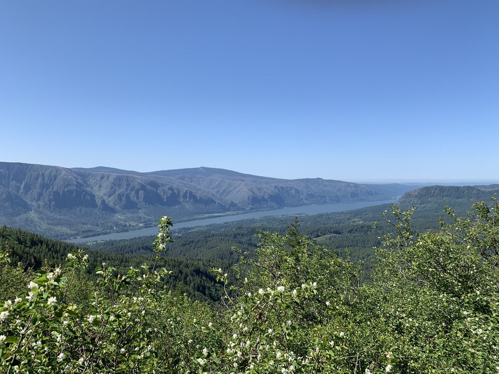
After another mile and a half, the road will end and the route will continue as a hiking only trail. After about mile of climbing the route crests Hardy Ridge offering a wide view of the Columbia River Gorge. The trail continues west descending the ridge.

But at the ridge you'll notice a 4-way intersection created by hikers going "off-trail" as they explore the ridge. Stay straight to continue on the Hardy Ridge Trail. Heading north up the ridge leads to the highpoint of Hardy Ridge.

Follow the trail as it descends down to a junction with the West Hardy Ridge Trail - turn left on the old logging road that leads back to the first intersection you arrived at when you started your hike. Here you will take a right and continue down to the equestrian campgrounds.

If you are looking to extend your hike, add on a lap around the Loop Trail or head over to the Bridget Trail and loop back on the Upper Hardy Creek Trail. For an Epic climb up Don's Cut-Off to summit Hamilton Mountain and return via the Hardy Creek Trail.

WTA worked here in 2021, 2018, 2016, 2015, 2013, 2012 and 2011!

Hike Description Written by
Ryan Ojerio, WTA Staff

Beacon Rock State Park - Hardy Ridge

Map & Directions

Trailhead
Co-ordinates: 45.6380, -122.0318 Open in Google Maps

Before You Go

See weather forecast

Parking Pass/Entry Fee

Discover Pass

WTA Pro Tip: Save a copy of our directions before you leave! App-based driving directions aren't always accurate and data connections may be unreliable as you drive to the trailhead.

Getting There

From Portland drive east on I-84 to the Bridge of the Gods in Cascade Locks. Cross the bridge and turn left on to Washington Highway 14. Drive about five miles to Beacon Rock State Park. Just past Beacon Rock turn right onto Kueffler Road. The trailhead is about half-mile up this road on the right side.

Alternatively, drive east on Highway 14 from Vancouver. Turn left on to Kueffler Road just before milepost 35.

The trailhead has a huge gravel lot to accommodate horse trailers. It also has a restroom, picnic tables, and hitching posts.

More Hike Details

Trailhead

Southwest Washington > Columbia River Gorge - WA

Washington State Parks

Guidebooks & Maps

Day Hiking: Columbia River Gorge. Craig Romano. Mountaineers Books. 2011.

http://parks.wa.gov/parks/thumbnailAndmaps/4150042.pdf

Beacon Rock State Park PDF Map: https://bit.ly/2QGUqWF

Buy the Green Trails Columbia Gorge West No. 428S map

You can improve or add to this guidebook entry

Beacon Rock State Park - Hardy Ridge

27 Trip Reports

Hiked here recently?

Submit a trip report!
 
Trip Reports