

This is a super-challenging trek that requires extra pre-planning and likely some route-finding experience, but promises a rugged, gorgeous few days in the landscape south and east of Stevens Pass.
You will need to arrange a key exchange or a pickup/dropoff before your trip — it's is a one-way outing that leaves Stevens Pass and wanders along Icicle Ridge into the town of Leavenworth. Along the way, you'll pass beautiful lakes and views of deep backcountry mountains.
The route is strenuous, with almost-constant elevation gain and loss, and in places the trail can be quite hard to follow. But those with route-finding experience and the drive to plan a technically (and logistically) challenging trip will be rewarded with stunning scenery and views.
From Stevens Pass, start off hiking south on the Pacific Crest Trail (PCT). You're heading towards Florence Lake and the high country past the Stevens Pass Ski Area. Pass Lake Susan Jane and 4.5 miles from the trailhead, arrive at a junction with the Icicle Creek Trail.
Here, you'll make a left onto Icicle Creek Trail, passing Josephine Lake (a lovely dayhike option out of Stevens Pass). Descend to a junction with the Chain Lakes Trail and turn left, crossing Icicle Creek (brr!) and soon arrive at the first of the Chain Lakes. Here the real trail gets tricky to follow — look for the one that crosses the second lake's outlet stream and traverses up to a pass at 6300 feet. On the other side of the pass are Doelle Lakes. The route traverses clockwise to the outlet stream of upper Doelle Lake and descends to the lower lake, 12 miles from the trailhead at Stevens Pass. Doelle makes a nice camping spot for the night.
To continue on, cross the outlet stream of lower Doelle Lake and follow the very faint Icicle Ridge Trail, heading for Frosty Pass which is 3 miles away. This section of the route is very faint and can be difficult to follow -- be sure to have a map and be able to read it.
A boot path descents toward a large meadow. Stick to the left of the meadow, and climb to the top of Icicle Ridge, crossing over it to Frosty Pass. Icicle Ridge trail intersects with the Frosty-Wildhorse Trail at the pass; stay on Icicle Ridge, heading south-southeast.
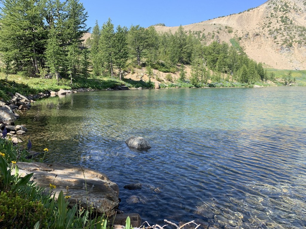
The trail traverses about Lakes Mary and Margaret, treating you to unbelievable views of the central Cascades and the Stuart Range. A camp at Florence Lake (accessed via a side trail) makes for a good night spot, though it's only 5 miles from Doelle Lakes.
From Florence Lake, return to the main trail and head to Ladies Pass. Icicle Ridge intersects with another trail, Chiwaukum Creek -- once again, stay on Icicle Ridge. The trail crosses slopes that hold snow late into the season. Be comfortable with snow safety measures if you're hiking here in late spring and early summer. The trail dips to tiny Lake Edna, vanishing at the lakeshore and then reappears as it descends again to cross Index Creek.
After all that elevation loss (2200 feet), you get to make it all back up! Arrive at the junction with Index Creek Trail, and once again, stay on the Icicle Ridge Trail and start climbing back up to a saddle at 6700 feet. Whew.
Now that the physical challenge of the day is over, it's time for the mental challenge: the trail vanishes here again. You'll need to make your way to the swampy pond named Carter Lake, stay right at a "junction" with the Painter Creek trail, and begin climbing (again) to a soaring pass (7,200 feet) on Big Jim Mountain. Lake Augusta lies below -- a good spot to camp after a rough day.
The trail undulates from Lake Augusta to a junction with Hatchery Creek trail. Stick to Icicle Ridge (to the right) and descend on hard-to-follow tread until it begins to switchback to the Cabin Creek valley floor. once you arrive at the floor it's a tough bushwhack through slide alder and then a crossing of Cabin Creek. Don't be surprised if you lose the trail here, too.
Navigate through marshy forest for a short distance, refill on water, then start climbing back uphill. It's 1800 feet of elevation to reach the top of Icicle Ridge and another junction with the Fourth of July Creek Trail. For a change of pace, get off the Icicle Ridge hike and turn left onto Fourth of July Creek.
The descent on the ridge is a knee-buckler after such a long hike. Take your time and enjoy the views from the ridge (one of the benefits of hiking through a former burn area, which is what most of this section of the trail is). You're almost there -- it's a switchbacking descent to the Icicle Ridge trailhead and the end of your hike.
WTA Pro Tip: There are a lot of camping options and a lot of ways to do this hike. Consult a map and strategize what your days might look like on this trek well before getting started on trail.
 Trailhead


