

Renowned for being able to "live in two worlds," So-To-Lick was dubbed Indian Henry by a mail carrier unable (or unwilling) to learn his real name. He guided the likes of John Muir, George Bayley, James Longmire and Philemon van Trump up sections of the massive mountain, but never summited it himself. Like many Native Americans, he considered the mountain sacred, never venturing onto the glaciers as it might bring bad luck.
The renowned guide has been memorialized for both his "Boston" name (Indian Henry) as well as his Native name. After So-To-Lick's death, van Trump named one of the many peaks that surround the hunting grounds after him: "Satulick Mountain."
The tranquil meadows are accessible in two ways: the Kautz Creek Trailhead near Longmire and via the West Side Road.
Overall, the trail that starts at the White River Road is kinder to your knees than the Kautz Creek access, though there are a couple of washouts that must be skirted by steep trail reroutes, and —with a 2-mile road walk before the actual trailhead — this way is considerably longer.
If you decide to explore Indian Henry’s Hunting Ground this way, park at the closure of the West Side Road and hike or bike up the road two miles. Wind your way through large boulders, which come down in spring avalanches, and cross two small creeks (one has a bridge, one does not). Carry on via a straightaway that parallels the river until the road bends around to the left, ascending into a green tunnel of trees. This crook is your departure point. Turn right off the road, onto a trail that is largely marked by cairns for the first section.
It’s a short forest walk before popping into the riverbed, where you’ll follow a well-marked trail along the edge of the roaring torrent of Tahoma Creek. In spring, this can be quite high; check conditions before heading out. After a half-mile of riverside walking and cairn following, the trail turns left back into the forest. Ascending along the hillside, the trail soon arrives at the first washout. Marvel at the river’s power that took such a large chunk out of the trail, then begin the steep climb up and over. Once past this washout, the trail resumes a moderate uphill grade to the second washout, steeper than the first. Clamber up and over exposed roots and descend sharply back down. Be careful here.
After conquering the two washouts, continue on, hiking along a gentle grade at first and then through some switchbacks leading up a ridge. At the top — 1.5 miles in — is a sign indicating that you’ve joined the Wonderland Trail. Take the right-hand fork, heading east on the Wonderland before arriving at a suspension bridge spanning Tahoma Creek. Cross the bridge and chug on uphill on the other side.
The trail maintains a steady grade for about 2 miles, leading you up hillsides, through green forest stocked with second-growth hemlocks and cedars, and stunning views of Rainier and the Tahoma Creek drainage and the glaciers that feed it.
One final push up and over a ridge puts you in sloping meadows carpeted with huckleberries and laced by little creeks: a precursor to your final destination. Continue on, arriving at a trail junction in Indian Henry’s Hunting Ground, 2.5 miles from where you joined the Wonderland Trail.
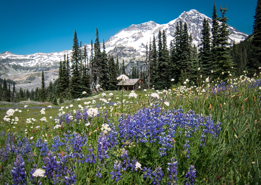
From this junction, there are plenty of options for exploration. Take the trail branching to the left to visit Mirror Lake, or continue straight on and arrive at the ranger’s cabin in about a quarter mile. From the cabin, rest up and imagine So-To-Lick living up here, hosting explorers and guiding them up the enormous mountain looming overhead.
WTA Pro Tip: Make the trip a thru-hike by continuing on the Wonderland and following the Kautz Creek trail out. Of course, you’ll need to arrange a shuttle in order to do this route, but with the stunning wildflowers and views of Rainier, Adams, St. Helens and the forests between spread out before you, it’s hard to turn around.
 Trailhead


