
The northern trailhead to Mitchell Peak (aka Mount Mitchell Trail) has been closed to the public since 2011. The trail is on epartment of Natural Resoures (DNR) land, but the access road traverses private property. DNR has an easement for administrative/natural resources work, but not one for recreational travel. After the property changed hands, the new owner chose to gate the road and curtail recreational use of the DNR lands beyond his property.
WTA has been working since the closure to get to the bottom of the Mitchell Peak TraIl and road situation. We have worked closely with DNR and are confident that they have exhausted all options to keep the road open. But we will continue to work with DNR staff to maintain the trail and promote access from the southern trailhead (North Siouxon Creek Trailhead).
There are no short alternate routes to Mitchell Peak trailhead, so hikers should avoid this trail for the foreseeable future. To access Mitchell Peak the long way, read our entry for Black Hole Falls, which describes the route from the North Siouxon Creek Trailhead.
Mitchell Peak

-
 Length
- 5.0 miles, roundtrip
-
 Elevation Gain
- 2,100 feet
-
 Highest Point
- 4,000 feet
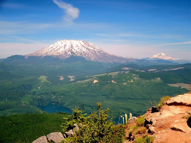
The Mitchell Peak Trail has two trailheads, the northern access has been closed to the public since 2011. A much longer hike (see Black Hole Falls Hike) is now required to get to summit where a Forest Service fire look out used to perch in beautiful sub-alpine terrain with panorama views of the major southwest Washington & Oregon volcanoes.
Continue reading
Hiking Mitchell Peak

WTA worked here in 2017!
Map & Directions
 Trailhead
Before You Go
Parking Pass/Entry Fee
NoneWTA Pro Tip: Save a copy of our directions before you leave! App-based driving directions aren't always accurate and data connections may be unreliable as you drive to the trailhead.
Getting There
From I-5. Take exit 21 (Woodland). If you're coming up from Vancouver, you'll turn right to head east on State Route 503 (Lewis River Hwy). Head east to the town of Cougar, about 30 miles.
Continue past Cougar for another 3.2 miles, passing Beaver Bay Campground. Make a right turn on an unmarked paved road. Go .3 miles and then cross a bridge, turn left on a gravel road and go 1.6 miles. At the junction, make a hard right turn. Go 2.4 miles and just before descending a hill, take the right fork onto Rd 1003. Go about a 1/4 mile more and look for a place to park on your left.


