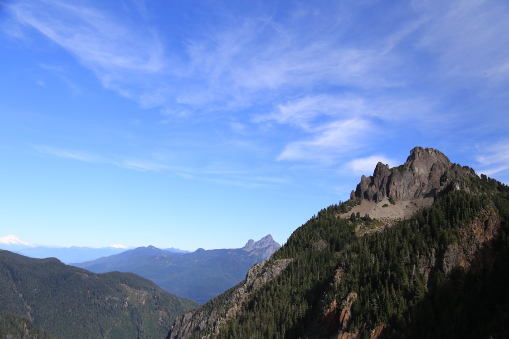

Mount Forgotten is an appealing target for the peculiarly determined hiker-turned-climber. Its sheer wall of a summit is very striking and easily instills visions of alpinism in those headed to Mount Forgotten Meadows, but the route takes a roundabout journey that requires not so much vertiginous daring-do as it does oodles of patience. The views from the top are spectacular, particularly the unobstructed view straight up Glacier Peak.
Start out at the Perry Creek Trailhead and follow the Perry Creek Trail to its end (full description here: http://www.wta.org/go-hiking/hikes/perry-creek). At the Mount Forgotten Meadows, head left to a spot where the high point above the tarns tapers down to the ridge. The biggest obstacle on the way to the top is here at the start, as the route drops over the edge. A short scramble without a lot of distinct holds (and very slippery when wet) ensues and descends to dirt and rock that is steep, but not quite steep enough to allow use of hands. After a hardscrabble loss of 200 feet in elevation, a rough, but distinct, trail emerges and traverses the southeast side of the mountain more or less in a straight, steadily ascending line.
The next six tenths of a mile will feel mostly like a hike. Only in spots does the trail get truly informal and seem to dead end against the bark of a random tree. If you lose your way, stay on your most recent line, and chances are the trail will pick up again pretty much exactly where you would expect it to.
After a long traverse and the occasional switchback, the trail reaches a broad shoulder on the east side of the peak looking out over the Sauk River drainage. The route now makes a hairpin turn, proceeding due west up a loose gully. After a short, steep climb over scree, the trail reaches solid ground again. From here, a surprisingly well groomed path proceeds through open slopes of heather.
And then the trail abruptly ends in a few relatively short boulders that mark the summit. From this direction, Mount Forgotten is tame as a kitten. What happened to that airy summit?
It hasn’t gone anywhere – the boulders of the summit mark the boundary between idyllic meadow and the sheer dropoff you may have gazed at longingly before deciding to march up here. A word to the wise if you pose for heroic mountaintop photos – remember where you are and watch your step! From this vantage, all the usual suspects (White Chuck, Pugh, Baker et al) dot the horizon, but Glacier Peak is the real star - there is nothing but open space between you and its volcanic slopes.
WTA Pro Tip: While the route is mostly tame and well established, the trail beyond the meadows and tarns is unmaintained. Some routefinding may be required, as other climbers (and animals) have created spur trails and shortcuts in spots.
Mount Forgotten

-
 Length
- 13.0 miles, roundtrip
-
 Elevation Gain
- 4,300 feet
-
 Highest Point
- 6,005 feet
The Mountain Loop Highway is closed between Deer Creek and Bedal Campground for the winter season.
Mount Forgotten is an appealing target for the peculiarly determined hiker-turned-climber. Its sheer wall of a summit is very striking and easily instills visions of alpinism in those headed to Mount Forgotten Meadows, but the route takes a roundabout journey that requires not so much vertiginous daring-do as it does oodles of patience. The views from the top are spectacular, particularly the unobstructed view straight up Glacier Peak.
Continue reading
Hiking Mount Forgotten
Map & Directions
 Trailhead
Before You Go
The Mountain Loop Highway is closed between Deer Creek and Bedal Campground for the winter season.
Parking Pass/Entry Fee
Northwest Forest PassWTA Pro Tip: Save a copy of our directions before you leave! App-based driving directions aren't always accurate and data connections may be unreliable as you drive to the trailhead.
Getting There
Take the Mountain Loop Highway east out of Granite Falls. From the Verlot Public Service center, continue along the Mountain Loop Highway for little more than 16 miles. Look for the well signed, large parking lot on the left (north) side of the road. Outhouses are available at the trailhead, and a Northwest Forest Pass is required.


