Trails for everyone, forever

Home Go Hiking Hiking Guide Mount Grant Preserve

Alert: On Oct. 1 the federal government began a partial shutdown that will impact National Parks, National Wildlife Refuges and U.S. Forest Service lands in Washington. Here's the latest information we have for hikers and campers


Mount Grant Preserve

Puget Sound and Islands > San Juan Islands
48.5446, -123.1215 Map & Directions
Length
4.6 miles of trails
Elevation Gain
900 feet
Highest Point
900 feet
Photo by trip reporter justas. Full-size image
  • Coast
  • Dogs allowed on leash
  • Fall foliage
  • Good for kids
  • Mountain views
  • Ridges/passes
  • Summits
  • Wildflowers/Meadows

Parking Pass/Entry Fee

None
Saved to My Backpack

Mount Grant Preserve is a trail system in development on San Juan Island. Currently, the trails to the top offer the most elevation gain available on San Juan Island, so you'll love this one if you're looking to get high up. Continue reading

Rating
5.00 out of 5

(3 votes) Log in to rate

Hiking Mount Grant Preserve

This location is one of San Juan Island's newest hiking destinations, boasting nearly five miles of trails to explore and accessible from the parking area at West Valley Road.

From here, walk past the gate, and begin your hike in lowland Douglas-fir and Western redcedar forest. You will quickly gain the east side of this ridge as you walk up existing roads. 

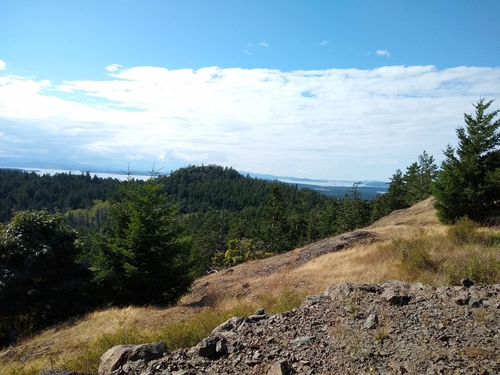
As you gain the ridge crest of Mount Grant, you’ll see towering old-growth Douglas firs, rocky balds abounding with uncommon prairie wildflowers, and views, views, views like you won’t get anywhere else in the islands. On a clear day you may get a glimpse of three of Washington’s five volcanoes: Mount Baker, Glacier Peak, and Mount Rainier.

The ridge top has ample areas to wander and delight in the surrounding islands and waterways, but please stick to existing trails…this is fragile habitat up here. You can continue on south along the ridge crest to make this hike a loop (1.9 miles round trip), or return on the road the way you came up.

Note: It's also possible to walk the road to the top, but be aware that if the access gate at the trailhead is open, the road is open to vehicles (this is the case two days a week). 

Background

Local conservation organizations have completed an ambitious project to permanently protect this 250-acre property and turned it into a publicly-accessible nature preserve. The area is still under development; read about the background and future plans for the preserve

Hike Description Written by
Kathleen Foley, WTA Correspondent

Mount Grant Preserve

Map & Directions

Trailhead
Co-ordinates: 48.5446, -123.1215 Open in Google Maps

Before You Go

See weather forecast

Parking Pass/Entry Fee

None

WTA Pro Tip: Save a copy of our directions before you leave! App-based driving directions aren't always accurate and data connections may be unreliable as you drive to the trailhead.

Getting There

From the Friday Harbor Courthouse, turn right on Guard St. In 2.75 miles, Guard Street becomes Beaverton Valley Rd. In 3.9 miles, Beaverton Valley Rd becomes West Valley Rd at the intersection with Boyce Rd. Turn left onto Richard Lee Ln in 0.8 mile. The parking lot will soon be on your right. 

More Hike Details

Trailhead

Puget Sound and Islands > San Juan Islands

San Juan County Land Bank

Guidebooks & Maps

http://sjclandbank.org/wp-content/uploads/2019/09/driving-directions-SEP-2019.pdf

You can improve or add to this guidebook entry!

Mount Grant Preserve

12 Trip Reports

Hiked here recently?

Submit a trip report!
 
Trip Reports