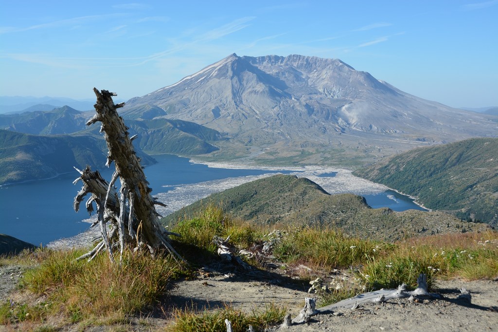

On maps, Mount Margaret doesn’t seem impressive enough to warrant its namesake Mount Margaret Backcountry. It is not the tallest nor the most majestic peak in the area. However, it is easily summited and it offers clear unobstructed views of Mount Rainier, Mount Adams, and Mount St. Helens (in three different directions), and expansive views of much more, including legendary Spirit Lake.
From the Norway Pass trailhead, take the Boundary Trail to the left and begin climbing the exposed slope. At 1.1 miles, go right at the junction with the Independence Ridge Trail. Over the next mile, huckleberries provide a welcome distraction in late summer. At 2.1 miles, intersect the Independence Pass Trail at Norway Pass. You'll get a glimpse of Spirit Lake and Mount St. Helens, but continue straight ahead for ever-improving views.
At 2.9 miles is another junction, this time with the Lakes Trail that leads up and over Bear Pass. Stay left on the Boundary Trail, climbing steadily. Round a ridge and drop slightly to Bear Camp at 4.1 miles. There is water available here into mid-season, but not always in late season.
Leaving Bear Camp, resume climbing steadily up and over a gentle pass at 5680 feet, then past a junction with the Whittier Ridge Trail at 4.7 miles. At 4.9 miles you might notice a faint scramble trail heading up to the right. This is not the Mount Margaret trail; keep going. At 5.3 miles is a very obvious (but unsigned) trail branching off to the right. Follow it 0.1 mile to the summit at 5780 feet, a rocky outcropping with room to wander around and enjoy the various views in all directions.
Take a panoramic look around, from Mount Rainier in the north-northeast and Mount Adams to the east. Gaze over Spirit Lake to the south, into the crater of Mount St. Helens. To the south-southwest, catch a glimpse of beautiful St. Helens Lake in a bowl at the base of Coldwater Peak. Now you'll understand why this is the Mount Margaret Backcountry.
Mount Margaret

-
 Length
- 11.0 miles, roundtrip
-
 Elevation Gain
- 2,820 feet
-
 Highest Point
- 5,780 feet
On maps, Mount Margaret doesn’t seem impressive enough to warrant its namesake Mount Margaret Backcountry. It is not the tallest nor the most majestic peak in the area. However, it is easily summited and it offers clear unobstructed views of Mount Rainier, Mount Adams, and Mount St. Helens (in three different directions), and expansive views of much more, including legendary Spirit Lake.
Continue reading
Hiking Mount Margaret
Map & Directions
 Trailhead
Before You Go
Parking Pass/Entry Fee
Northwest Forest PassWTA Pro Tip: Save a copy of our directions before you leave! App-based driving directions aren't always accurate and data connections may be unreliable as you drive to the trailhead.
Getting There
From the town of Randle, drive south for 20 miles on what begins as State Route 131 and in a few miles becomes Forest Road 25. Turn right from FR 25 onto FR 99 and travel 9 miles, then right on FR 26 one mile to the trailhead. The parking lot has two vault toilets and room for about 35 vehicles. There is no water available.
From Cougar, take the Lewis River Road east for 2.8 miles, which then changes to FR 90. Continue on FR 90 for 16 miles, then stay to the left on FR 25, passing the Pine Creek Information Center. Drive FR 25 for 25 miles to the junction of Forest Road 99, and turn left onto Forest Road 99 towards Windy Ridge. Drive approximately 9.2 miles to Forest Road 26 and turn right. The Norway Pass Trailhead will be on your left on Forest Road 26.


