Trails for everyone, forever

Home Go Hiking Hiking Guide Pacific Way Trail
WTA is a nonprofit that needs you

We're just as excited as you to get the summer hiking season started. We're psyched our website, app and work for trails help you get outside.

But we're a nonprofit that runs on donations from regular people. If everyone who visited this site this holiday weekend donated $9/month, it would fully fund our work for the next 2 years. Time spent outdoors is priceless, but every donation large or small helps us support those experiences for everyone. Thank you and happy hiking!


Please take 2 minS to chip in $9

link

Pacific Way Trail

Southwest Washington > Columbia River Gorge - WA
46.1564, -122.9551 Map & Directions
Length
2.0 miles, one-way
Elevation Gain
20 feet
Highest Point
20 feet
Calculated Difficulty About Calculated Difficulty
Easy
Water feature of Pacific Way Trail Full-size image
  • Wildlife
  • Good for kids
  • Dogs allowed on leash
  • Fall foliage

Parking Pass/Entry Fee

None
Saved to My Backpack

Take this wide, graveled path to get a quick dose of nature near home. Continue reading

Rating
0.00 out of 5

(0 votes) Log in to rate

Hiking Pacific Way Trail

This trail along Pacific Way offers a nice way to enjoy nature in town. While it's 2.5-miles long, it is broken up by a gated section that passes the Mint Valley Golf Course.

Still, it's possible to enjoy a mile or so of walking on either end of this trail. Starting from a fair-sized parking area at 30th Avenue, visitors can walk, bike, or jog. If you visit with pups, please keep them on leash; the area is a nesting area for wild fowl between March and July. 

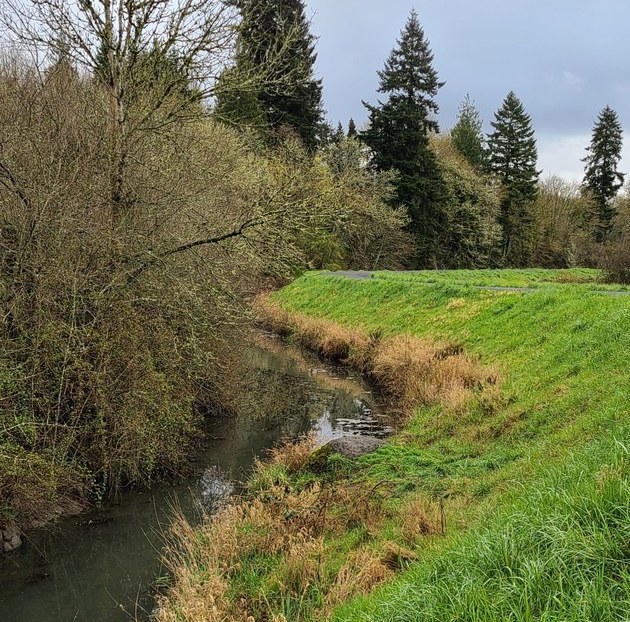
Expect to spy ducks and other birds in the water, as well as a variety of reeds and huge trees opposite you as you walk. Unfortunately, the dike itself is unshaded and this area can be very hot in summer. Bring water, even if it's just a short walk. 

1.18 miles from the trailhead, arrive at 38th Ave. Across the street is the Mint Valley Golf Course. At the other end of the section of trail that borders the golf course, you can rejoin the trail at 42nd Ave and continue all the way to where it ends at 48th Avenue. 

The entire length is 2.5 miles, making for a 5-mile roundtrip if you hike from end to end and back. 

Hike Description Written by
Multiple authors contributed to this report, WTA Community

Pacific Way Trail

Map & Directions

Trailhead
Co-ordinates: 46.1564, -122.9551 Open in Google Maps

Before You Go

See weather forecast

Parking Pass/Entry Fee

None

WTA Pro Tip: Save a copy of our directions before you leave! App-based driving directions aren't always accurate and data connections may be unreliable as you drive to the trailhead.

Getting There

Driving directions

The parking area for the trailhead off 30th Ave is next to the Longview United Methodist Church. The trailhead off 48th is much smaller and more difficult to find parking on.

take transit

Take the bus to the trailhead! Plan your trip by bus using TOTAGO.

More Hike Details

Trailhead

Southwest Washington > Columbia River Gorge - WA

City of Longview

You can improve or add to this guidebook entry!

Pacific Way Trail

1 Trip Report

Hiked here recently?

Submit a trip report!
 
Trip Reports