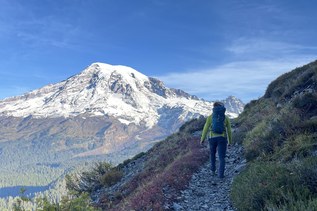
This trail takes hikers out of the maze of trails at Paradise and up onto one of the many glaciers on Washington's most iconic mountains.
Begin by heading up the wide steps outside the entrance to Paradise Inn. The trail is not marked by signs, but heading toward Myrtle Falls on the Skyline Trail puts you on the right path. Pass the falls and look for a junction with the Golden Gate Trail. Stay right, and continue on Skyline Trail for 1.8 miles to the Paradise Glacier spur trail.
At this point you leave the crowds of the Skyline Trail behind as you travel toward and into the moraine. Soon, arrive at a sign marking the end of the maintained trail. Continuing on arrive after a quarter mile to a sign warning of danger in and around the ice caves. However, the caves are no longer there and judging by the deterioration of the sign it won't be there much longer either.
This is the end of the Paradise Glacier trail, but intrepid hikers can continue through the rock/boulder field to a small waterfall. On this section, there are a lot of small streams to cross so waterproof boots are a must.
Return the way you came, or finish it as a loop, taking the Skyline Trail to Paradise Point, where you can enjoy views of the Goat Rocks, Mount Adams, Mount Hood and St. Helens before heading back down, rejoining the crowds on the steep descent to your car.
Paradise Glacier

-
 Length
- 5.6 miles, roundtrip
-
 Elevation Gain
- 1,495 feet
-
 Highest Point
- 6,409 feet
This trail takes hikers out of the maze of trails at Paradise and up onto one of the many glaciers on Washington's most iconic mountains.
Continue reading
Hiking Paradise Glacier
Map & Directions
 Trailhead
Before You Go
Parking Pass/Entry Fee
National Park PassWTA Pro Tip: Save a copy of our directions before you leave! App-based driving directions aren't always accurate and data connections may be unreliable as you drive to the trailhead.
Getting There
Learn how to secure your timed-entry permit for Mount Rainier National Park here.
From the west, take SR 7 from Tacoma and bear left on SR 706 in Elbe. Go through the Nisqually Entrance of Mt. Rainier National Park and head up to the Narada Falls View Area parking lot. Note that the Paradise road closes each evening in winter and reopens only when plowed; sometimes there is a long wait at Longmire.