Trails for everyone, forever

Home Go Hiking Hiking Guide Peewee Falls Overlook and Boundary Dam Overlook

Alert: On Oct. 1 the federal government began a partial shutdown that will impact National Parks, National Wildlife Refuges and U.S. Forest Service lands in Washington. Here's the latest information we have for hikers and campers


Peewee Falls Overlook and Boundary Dam Overlook

Eastern Washington > Selkirk Range
48.9764, -117.3392 Map & Directions
Length
0.2 miles, roundtrip
Elevation Gain
50 feet
Highest Point
2,532 feet
Calculated Difficulty About Calculated Difficulty
Easy
Hooknose Mountain and Peewee Falls from the overlook trail. Photo by Mary Hartman. Full-size image
  • Dogs allowed on leash
  • Fall foliage
  • Good for kids
  • Mountain views
  • Rivers
  • Waterfalls
  • Wildflowers/Meadows

Parking Pass/Entry Fee

None
Saved to My Backpack

A short trail leads to a spectacular view across the Pend Oreille River Canyon, where Peewee Falls plunges 233 feet into the Boundary Lake Reservoir. A nearby viewpoint overlooks Boundary Dam. Continue reading

Rating
5.00 out of 5

Hiking Peewee Falls Overlook and Boundary Dam Overlook

Unlike most of our state’s rivers, the Pend Oreille flows almost straight north between Newport, Washington, and the Canadian border. Several hydroelectric dams cross the steep canyon in northeastern Washington, including Boundary Dam near the border. In 2023, the U.S. Forest Service and Seattle City Light opened two new overlook areas designed to meet Forest Service accessibility guidelines: Riverside Canyon and Peewee Falls. Construction of the overlooks fulfilled one of the requirements under Seattle City Light’s license to operate Boundary Dam. Seattle City Light funds also paid for an upgrade to the nearby Boundary Dam overlook.

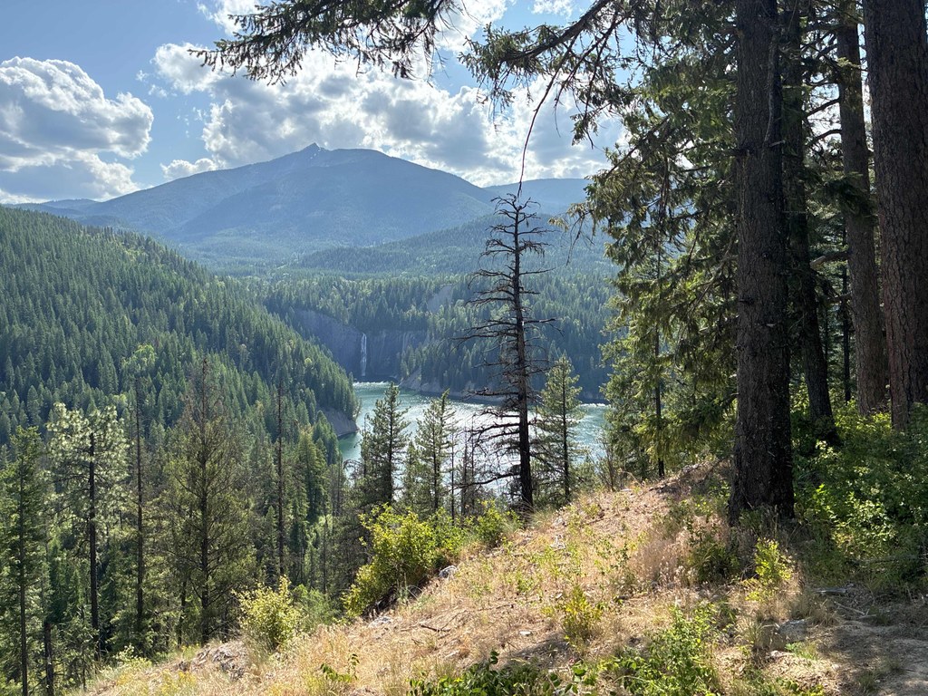
The trail from the parking area descends through a few switchbacks, leading to a viewing platform with benches where you can relax and enjoy the view of Peewee Falls and Hooknose Mountain across the valley.

After you leave the Peewee Falls overlook, turn left on Eastside Access Road and visit Vista House, where you’ll get a clear view of Boundary Dam. A short trail descends from Vista House to an overlook platform. 

A 9-mile hiking trail connecting the Peewee Falls and Riverside Canyon Overlooks, also funded by Seattle City Light, is nearly complete as of 2025.

Toilet Information

  • Toilet at trailhead
  • Accessible toilet

More information about toilets

Wheelchair Accessibility

The parking area at Peewee Falls Overlook has space for 15 cars, and includes van-accessible parking, accessible toilets, and picnic tables. The wide trail to the overlook is compacted gravel and was designed to comply with Forest Service trail accessibility guidelines. Parts of the trail may be steep for some wheelchairs, so you might want to bring a helper. The spacious viewing platform is wheelchair accessible.

Hike Description Written by
Mary Hartman, WTA Correspondent

Peewee Falls Overlook and Boundary Dam Overlook

Map & Directions

Trailhead
Co-ordinates: 48.9764, -117.3392 Open in Google Maps

Before You Go

See weather forecast

Parking Pass/Entry Fee

None

WTA Pro Tip: Save a copy of our directions before you leave! App-based driving directions aren't always accurate and data connections may be unreliable as you drive to the trailhead.

Getting There

From Metaline Falls, drive north on WA-31 for 11.5 miles (if you get to Canada, you’ve gone too far!). Turn left onto Eastside Access Road / Crescent Lake Recreation Area. Drive past the Crescent Lake Campground for 0.9 mile, where you’ll see a sign for Peewee Falls Overlook. Turn left onto this good gravel road and follow the signs to the parking area. 

More Hike Details

Trailhead

Eastern Washington > Selkirk Range

Colville National Forest, Newport-Sullivan Lake Ranger District

Guidebooks & Maps

https://www.fs.usda.gov/r06/colville/recreation/peewee-falls-scenic-overlook

USGS Sullivan Lake

You can improve or add to this guidebook entry!

Peewee Falls Overlook and Boundary Dam Overlook

2 Trip Reports

Hiked here recently?

Submit a trip report!
 
Trip Reports