Trails for everyone, forever

Home Go Hiking Hiking Guide Pickhandle Gap Loop
link

Pickhandle Gap Loop

Mount Rainier Area > Chinook Pass - Hwy 410
46.9369, -121.4692 Map & Directions
Length
8.0 miles, roundtrip
Elevation Gain
2,000 feet
Highest Point
6,200 feet
Calculated Difficulty About Calculated Difficulty
Moderate/Hard
View from the PCT along the loop. CapnCrumples.
  • Wildflowers/Meadows
  • Mountain views
  • Dogs allowed on leash
  • Lakes
  • Ridges/passes

This is a great loop which combines everything great about hiking at Crystal, while staying away from crowds and out of the ski area. Continue reading

Rating
0.00 out of 5

(0 votes) Log in to rate

Hiking Pickhandle Gap Loop

This is a great loop which combines everything great about hiking at Crystal, while staying away from crowds and out of the ski area.

Start at the Silver Creek Trailhead and follow the Silver Creek Trail to Henskin Lake. From the southeast corner of the lake, turn left on the Bear Gap Trail and continue .7 miles slightly uphill to Bear Gap.

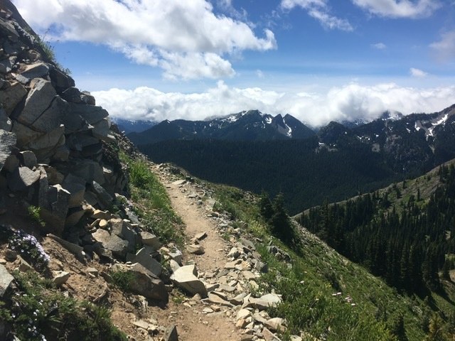
At Bear Gap you will run into the Pacific Crest Trail (PCT) #2000. You may be able to chat with some thru hikers at this intersection – fun! Follow the PCT north for a little over a mile to Pickhandle Gap on the sunny backside. This can be a hot, dry section, so bring water. Views of Mt Adams are to your right, south, while Mount Rainier dominates to the west.

Once at Pickhandle Gap, continue on the PCT to the ridge above Bullion Basin and then drop down into the basin on the Bullion Basin Trail for another 2 miles to end the loop.  

Directions are crucial on this hike, but it is a super one!

Hike Description Written by
Janice Sears, WTA Community

Pickhandle Gap Loop

Map & Directions

Trailhead
Co-ordinates: 46.9369, -121.4692 Open in Google Maps

Before You Go

See weather forecast

WTA Pro Tip: Save a copy of our directions before you leave! App-based driving directions aren't always accurate and data connections may be unreliable as you drive to the trailhead.

Getting There

Silver Creek Trailhead: From Enumclaw, drive east on Highway 410 for 33.1 miles, then turn left on the Crystal Mountain Parkway (#7190) for 4.2 miles. Turn left onto Gold Hills Road for another 3 miles to the trailhead on the right side of the road. 

Alternate trailhead at Crystal Mountain upper parking lot: Follow the directions above, but instead of turning left onto Gold Hills Road, stay straight on Crystal Mountain Parkway for a total of 6.4 miles, from Highway 410. Park in the upper lot (Parking lot A) and find the Bullion Basin Trail just beyond the chapel. Follow this trail a short distance to the first intersection where you can turn right to get on the Silver Creek Trail, which is where this hike description starts. 

More Hike Details

Trailhead

Mount Rainier Area > Chinook Pass - Hwy 410

Silver Creek (#1192), Henskin Lake (#1193), PCT Section I (#2000), Bullion Basin (#1156)

Mt. Baker-Snoqualmie National Forest, Snoqualmie Ranger District

You can improve or add to this guidebook entry

Pickhandle Gap Loop

33 Trip Reports

Hiked here recently?

Submit a trip report!
 
Trip Reports