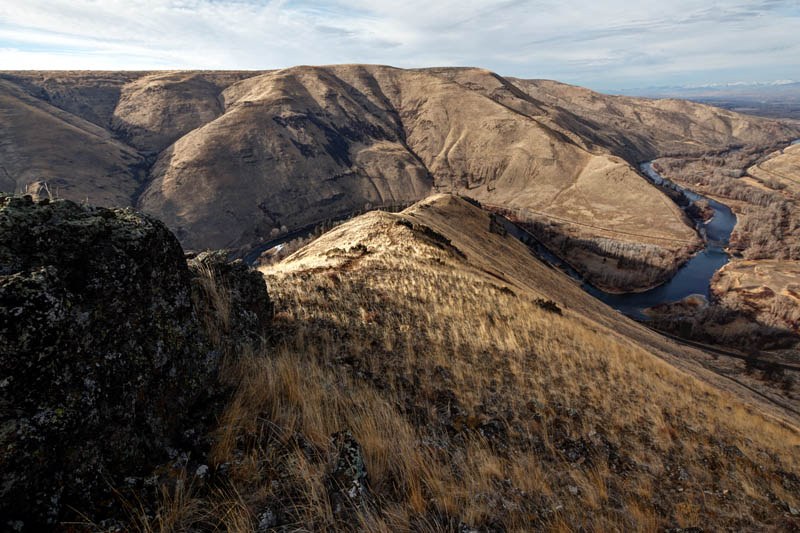

This short, steep and fairly rough hike climbs up a ridge crest on the north end of the Yakima Canyon, ending at a 2,646 foot summit marked by a tall wooden pole (and a summit register within an ammo box). The ascent offers fantastic views all around, particularly north up into the farmlands at the north end of the Canyon, and south down the serpentine Yakima Canyon. Notice the entire Stuart Range to the north and Mount Rainier peaking over the horizon to the west.
After ascending 1,250 feet in 1 mile, consider strolling a few hundred yards to the SE for a better view down-canyon. From mid-April to mid-May, this area puts on an incredible wildflower show, highlighted by dancing yellow balsamroot.
Remember to bring plenty of water, there is none on the trail.
This trail goes between two parcels of private land. Please respect all signage and fences when hiking here.
Rattlesnake Dance Ridge Trail

-
 Length
- 2.0 miles, roundtrip
-
 Elevation Gain
- 1,250 feet
-
 Highest Point
- 2,646 feet
A short, steep and rough ridgeline ascent to a summit with great views up and down the Yakima River Canyon.
Continue reading
Hiking Rattlesnake Dance Ridge Trail
Map & Directions
 Trailhead
Before You Go
Parking Pass/Entry Fee
NoneWTA Pro Tip: Save a copy of our directions before you leave! App-based driving directions aren't always accurate and data connections may be unreliable as you drive to the trailhead.
Getting There
To find the trail head, drive Hwy 821 (Canyon Road) south out of Ellensburg. Look for a wide parking area on the east side of the highway just around the first leftward hair-pin curve entering the north end of the Yakima Canyon. A trail cuts up the road cut from the parking area, where you will find a sign marking "Rattlesnake Dance Ridge Trail". The way then traverses up to the ridge crest and follows this crest to a summit marked by a 10 foot pole.


