

From the trailhead on Forest Road 65 just beyond the Falls Creek Horse Camp, hike Indian Racetrack Trail (#171) southeast through second-growth forest. In about 0.2 mile, reach the wilderness information board and permit box at the junction with a spur trail from the horse camp.
Just around the corner, cross Falls Creek, either on the log bridge (handrail destroyed by snow load) or by rock-hopping the horse ford. Beware: The rocks are slippery, according to hikers who have chosen that crossing. This is the only place on the hike to filter water.
Enter the Indian Heaven Wilderness and begin climbing up a ridge through rocky terrain. WTA-built check steps help for a while until the terrain becomes more rocky and the trail more trenched and eroded. Some user-made bypasses help get past the worst sections.
After about a mile, the grade lessens. Cross over a gentle ridge, descend through a former meadow and climb over another ridge. The forest has a more expansive feel here. Then the trail heads downhill towards the Indian Racetrack. Emerge out of the forest at the shallow, marshy, sometimes dry, Racetrack Lake at 2 miles from the start.
Continue ahead around the east side of the lake to arrive at the Indian Racetrack, where the Yakama, Klickitat and Columbia River tribes gathered each year, since time immemorial, in a large camp. The forest is reclaiming what was once a large, open flat area suitable for horse racing and horsemanship competitions. People also harvested and dried huckleberries and hunted game to prepare food stores for winter.
At the racetrack, the trail to the left connects to the Pacific Crest Trail in a half mile. Turn right and walk in the rut of the racetrack about 0.1 mile to the continuation of the Indian Racetrack Trail up Red Mountain. Look for a sign on the left of the track.
The trail leads south, flat at first, then climbing moderately up the shoulder of Red Mountain. Huckleberries encroach on the trail. As the forest canopy thins and allows more sunlight, huckleberries may be an excuse to take a break. At the ridge crest, the trail turns right and climbs steeply straight up the slope of Red Mountain.
At 3.1 miles from the start, the trail leaves the boundary of the Indian Heaven Wilderness. Continue climbing another 0.3 mile to the trail terminus at FR 6048, the access road to the Red Mountain Lookout. This road is permanently gated down below at its junction with FR 60, so you don't need to watch for traffic.
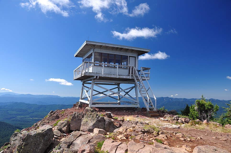
Turn right and continue around the corner to hike up to the base of the Red Mountain Lookout tower. Soak in the 360-degree view of the South Cascades. Use a map to identify all the lesser landmarks besides Mount St. Helens, Mount Adams and Mount Hood. Return the way you came.
The Red Mountain Lookout was the first one built on the Gifford Pinchot National Forest, in 1910, and it has been replaced twice over the years. The current lookout was built in 1959. During the winter of 2006, a windstorm tore open the roof, and the building filled with snow. In 2010, 13 volunteers with the Passport in Time program restored the current lookout using salvaged and authentic materials. The Passport in Time program is a Forest Service program that allows volunteers the opportunity to garner archaeology and historic preservation skills.
The Red Mountain Lookout is no longer staffed now that satellites are used for fire detection.

 Trailhead


