Trails for everyone, forever

Home Go Hiking Hiking Guide Sakai Park

Sakai Park

Puget Sound and Islands > Seattle-Tacoma Area
47.6238, -122.5123 Map & Directions
Length
3.0 miles, roundtrip
Elevation Gain
280 feet
Highest Point
200 feet
Calculated Difficulty About Calculated Difficulty
Easy/Moderate
Pia the Troll sitting at the park. Photo by Jennie Flaming. Full-size image
  • Dogs allowed on leash
  • Good for kids

Parking Pass/Entry Fee

None
Saved to My Backpack

A forest walk near the Bainbridge Island Ferry Terminal featuring forest, a pond and one of the new trolls. Continue reading

Rating
3.00 out of 5

Hiking Sakai Park

Sakai Park is named for the Sakai Family who farmed this land as a strawberry farm until they were sent to an internment camp during World War II. After the war, they returned to the land and ultimately sold it to the Bainbridge School District. 

From the ferry terminal, it is a one-mile walk on a paved, separated trail alongside SR 305 that is smooth and barrier-free and gains 200 feet of elevation. Turn left and cross the street at the junction with High School Road NE. At the next intersection, turn right onto Madison Ave N — the park will be on your right. 

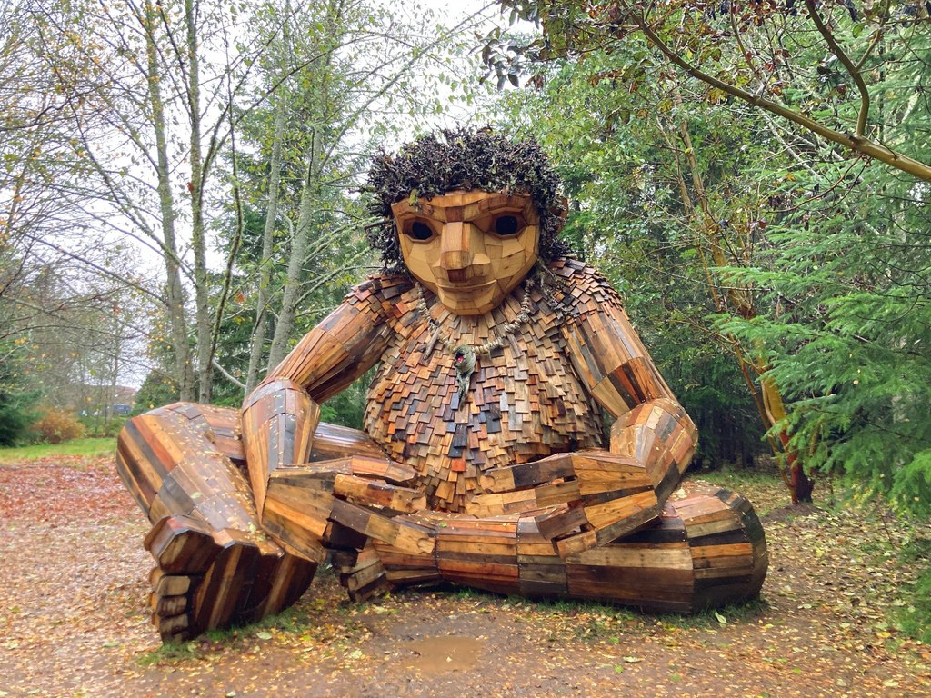
It’s a short walk on a wood chip trail to Pia, one of the new trolls across the Greater Seattle area. 

From there, you can do a short loop around the park, or head down across the creek to the pond and across to the intersection by the Safeway shopping area.

All the trails are wide, wood-chipped and smooth, no roots or rocks. Watch out for deep water on some trails during times of heavy rain. The trails in a loop around the troll on the Madison Ave side of the park are flat. If you go down to the pond you will lose and then gain about 40 feet (80 feet if you continue up to the trail on the east side of the park).

The trails near the troll are more open meadow surrounded by forest, and deeper forest is around you near the pond and the creek. 

There is a wheelchair-accessible port-a-potty near the parking and the troll (within 200 feet).

This is an excellent year-round hike! Some low parts of the trail near the pond may be underwater during times of heavy rain.

Toilet Information

  • Toilet at trailhead

More information about toilets

Wheelchair Accessibility

There is a wheelchair-accessible port-a-potty near the parking lot at the park and the troll (within 200 feet).

Hike Description Written by
Jennie Flaming, WTA Correspondent

Sakai Park

Map & Directions

Trailhead
Co-ordinates: 47.6238, -122.5123 Open in Google Maps

Before You Go

See weather forecast

Parking Pass/Entry Fee

None

WTA Pro Tip: Save a copy of our directions before you leave! App-based driving directions aren't always accurate and data connections may be unreliable as you drive to the trailhead.

Getting There

Trailhead has very limited parking (three spots on Madison Ave, the only official parking for the park).

It is a one-mile walk from the Bainbridge Island Ferry Terminal on a paved, separated trail that is smooth and barrier-free and gains 200 feet of elevation from the ferry.

To take the bus, take the 95 bus from the ferry terminal which runs every hour and get off at Safeway about a quarter mile from the park.

More Hike Details

Trailhead

Puget Sound and Islands > Seattle-Tacoma Area

Bainbridge Island Metro Parks and Recreation

Guidebooks & Maps

https://biparks.org/wp-content/uploads/2022/06/trali_map_sakai_park_print_6.3.22.pdf

You can improve or add to this guidebook entry!

Sakai Park

9 Trip Reports

Hiked here recently?

Submit a trip report!
 
Trip Reports