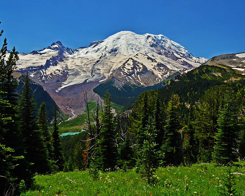

This sweet little loop leaves from the Sunrise Visitor Center at Mount Rainier and encompasses a lovely little lake, an unexpected campsite, and views of the mountain's eastern flanks and glaciers.
From Sunrise, at 6400 feet, follow the large staircase heading northeast (between the bathrooms and the cafe). Climb the long, wide steps up to a junction with the Sourdough Ridge Trail, 0.7 miles from the trailhead. Peer into Huckleberry Basin, then hang a left, and gradually climb to 6800 feet in 0.3 miles.
Here, you'll find a junction with the trail to Forest Lake branching off to the right. Continue straight on, passing talus slopes that may house pikas chirping or marmots sunning. After 0.8 miles, arrive at Frozen Lake. Off limits to hikers, this large lake serves as the water source for Sunrise. The junction here has a myriad of options: Burroughs Mountain, Berkeley Park, Fremont Lookout, but your route is to your left, a nearly 180-degree switchback that leaves the little saddle that houses this junction, and descends 400 feet in a little more than a half mile to another junction.
This one offers either a road walk, or to your left, a narrower trail. Though the road walk is more direct, and may be a welcome shortcut for families with fussy kids, the trail to your right is more scenic. Take it.
Continuing on in the basin, find yourself with an up-close view of wildflowers and grassy fields. In 0.4 miles, arrive at Sunrise Camp. This little camp is part of the Wonderland Trail, which makes its existence just behind Sunrise Visitor Center make a little more sense.
Hike through Sunrise Camp and continue on a flatly traversing trail, passing a murky lake. This is Shadow Lake, and a trail branching off to the left offers a detour and a nice place for a picnic if you wish. Otherwise, continue hiking straight on. It's a half mile past the lake that you come upon yet another junction. A right turn here takes you down along the Wonderland Trail, a steep 2.6 miles to the White River valley.
Fortunately, your route is much flatter and shorter. Continue straight ahead for half a mile, then a left hand turn leads up a short slope into the south side of the Sunrise parking lot.
Shadow Lake - Sunrise Camp Loop

-
 Length
- 3.7 miles, roundtrip
-
 Elevation Gain
- 200 feet
-
 Highest Point
- 6,386 feet
The road to Sunrise is closed for the winter season. It is expected to reopen in July 2026.
Parking Pass/Entry Fee
National Park PassPermits Required
Backcountry camping permit. Reserve online (fee)
This sweet little loop leaves from the Sunrise Visitor Center at Mount Rainier and encompasses a lovely little lake, an unexpected campsite, and views of the mountain's eastern flanks and glaciers.
Continue reading
Hiking Shadow Lake - Sunrise Camp Loop
Map & Directions
 Trailhead
Before You Go
The road to Sunrise is closed for the winter season. It is expected to reopen in July 2026.
Parking Pass/Entry Fee
National Park PassPermits Required
Backcountry camping permit. Reserve online (fee)WTA Pro Tip: Save a copy of our directions before you leave! App-based driving directions aren't always accurate and data connections may be unreliable as you drive to the trailhead.
Getting There
From Enumclaw, follow SR 410 east for 43 miles until you reach Sunrise Park Rd/White River Rd. Make a slight right at the fork and follow along for 5 miles and over the White River. The road then switchbacks to become exclusively Sunrise River Rd and continues 10 miles to its end at the Sunrise Visitor Center and the parking area.


