Trails for everyone, forever

Home Go Hiking Hiking Guide Slate Creek Trail
link

Slate Creek Trail

Eastern Washington > Spokane Area/Coeur d'Alene
47.4716, -115.9239 Map & Directions
Length
15.0 miles, roundtrip
Elevation Gain
2,400 feet
Highest Point
5,702 feet
Calculated Difficulty About Calculated Difficulty
Hard
Gorgeous Slate Creek at sunset. Photo by austineats. Full-size image
  • Dogs allowed on leash

Parking Pass/Entry Fee

None

This hike is across the Washington border in Idaho, but provides a lovely outing near the historic town of Wallace. Continue reading

Rating
0.00 out of 5

(0 votes) Log in to rate

Hiking Slate Creek Trail

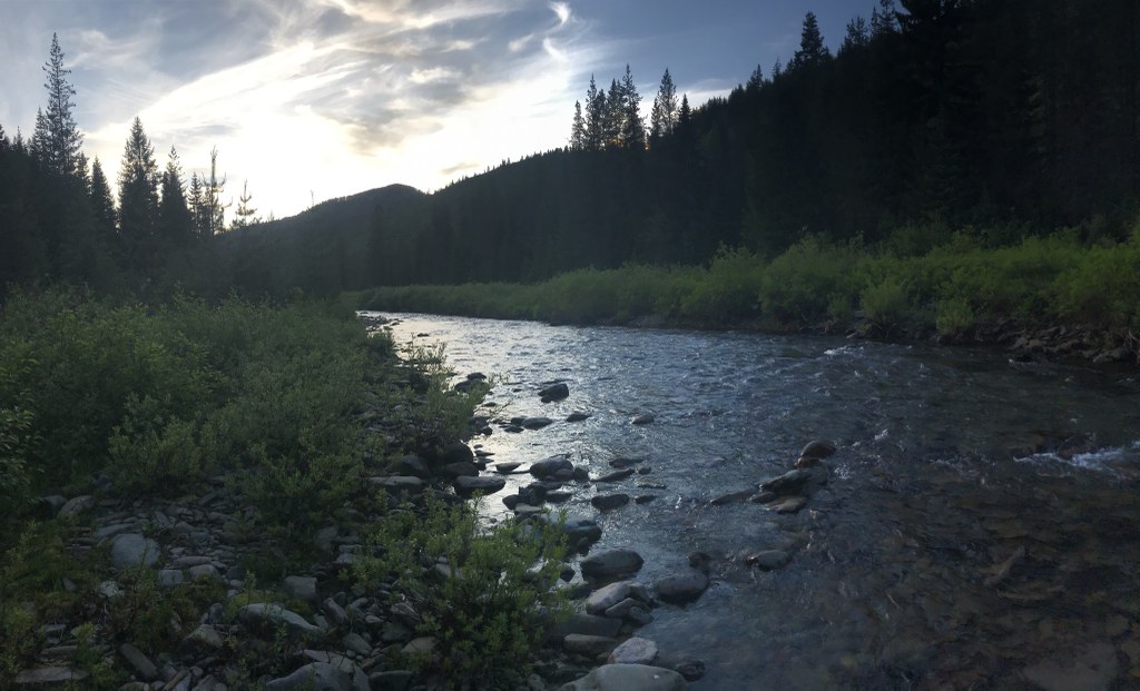
The country south of Wallace, Idaho is old-school, Inland Northwest country. The trails are rugged, mixed use trails, where you are just as likely to encounter a moose or bear as you are a dirt-biker. The first few miles gains little elevation as it parallels Slate Creek and its attendant meadows. In the summer, flowers and braided creeks mix with gravel bars. Ridgelines tower over both sides of the valley.

Indigenous people have lived and used these lands for years, and others have laid down history here, too. As you wander up valley imagine the eras past of loggers and miners, and the people who were here when settlers arrived. Peaks have curious names like Fool Hen, Mastodon, and Bad Tom, eliciting visions of stories on how these came to be. Dam Creek might be another of questionable etymology or provenance.

There are no bridges in these parts and should you choose to venture past Dam Creek you will get your feet wet as the trail ambles back and forth across the drainage. Another few miles and the trail enters Elbow Gorge, a narrow and infrequently visited defile.

This gorge makes a ninety degree turn to the west before making a stout 1700 foot ascent in under two miles to the ridgeline above. All along this route are side trails to former fire lookouts and lonely ridges. Loops could be made for the adventurous and those not afraid of getting a little lost. Otherwise stick to the creek bottom and enjoy the flora and fauna. Look for mushrooms or wildflowers and relish the solitude.

WTA Pro Tip: Wallace, Idaho is a great town. It’s architecture is decidedly late 19th/early 20th century mining town. I-90 initially passed this town by in the 80s but this has blessed the town by retaining its charm.

Hike Description Written by
Austin Smith, WTA Correspondent

Slate Creek Trail

Map & Directions

Trailhead
Co-ordinates: 47.4716, -115.9239 Open in Google Maps

Before You Go

See weather forecast

Parking Pass/Entry Fee

None

WTA Pro Tip: Save a copy of our directions before you leave! App-based driving directions aren't always accurate and data connections may be unreliable as you drive to the trailhead.

Getting There

From the town center in Wallace, Idaho head west out of town on Cedar Street. Zig-zag a bit to get onto King Street as it leaves town heading SSW in under a mile. Follow this road, which turns into FS 456, for 9+ miles to Moon Pass. Turn left at this pass onto FS 485 towards Slate Creek Saddle. At 11+ miles from Wallace you will reach Slate Creek Saddle. Take a hard right here onto FS 225. At 14+ miles you will reach a sharp righthand turn in the road at Horseshoe Creek. An even sharper righthand road turns down creek AT THIS INTERSECTION. Approximately 1 and ½ miles down this steep and loose dirt road (16 miles total from town) is the trailhead. There are sani-cans along this route as well as campsites. There are NOT facilities at the trailhead.

Be forewarned! The last quarter mile is prone to flooding by beavers! This is a perennial issue which I believe the beavers are winning. Be sure to bring some wading shoes. There is plenty of parking along the road. Turning a trailer around here would be near impossible.

More Hike Details

Trailhead

Eastern Washington > Spokane Area/Coeur d'Alene

You can improve or add to this guidebook entry

Slate Creek Trail

1 Trip Report

Hiked here recently?

Submit a trip report!
 
Trip Reports