
The network of trails on the Anacortes Community Forest Lands is extensive enough that you can spend all day hiking and exploring here. Maps for the area are available at the City Hall in Anacortes, as well as the bookstore, the two bike shops in town, and the Mount Erie grocer, which you pass on the way to the trailhead.
While it’s not quite as tall as nearby Mount Erie, Sugarloaf makes a great summit—this one doesn’t have a parking lot at the top.
From the trailhead off the Heart Lake Road, walk along a flat, wide trail for a short while. Your map indicates that you are passing a lake, but it’s more like a marshland. You’re hiking along Trail 215, which you’ll utilize for most of your hike, but its character changes dramatically during the journey.
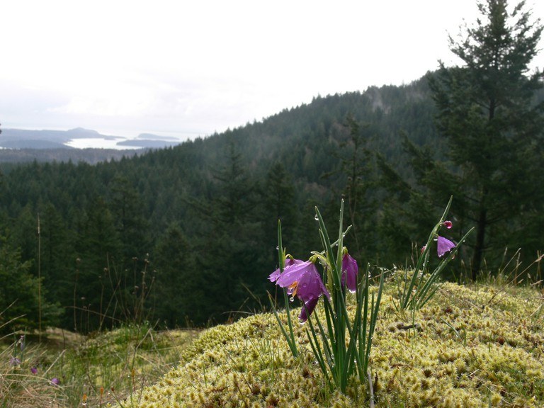
After a short, gentle jaunt through the valley, Trail 215 takes off sharply from the valley floor, climbing 520 feet in just about three-quarters of a mile. Most of the elevation gain comes in the first quarter mile, so your heart will be pumping by the time you hit a viewpoint that opens out onto Burrows Bay and the San Juan Islands. After the initial climb, the trail becomes slightly more like a staircase, with sections of incline alternating with flatter sections, but use the viewpoint as an excuse to catch your breath before pressing on.
The trail switchbacks almost immediately past the viewpoint. Continue climbing—it’s not much farther now! Wind around the summit block and arrive at a crossroads. Straight ahead is a wooden, hiker-only gate with a sign indicating Trail 238. Walk through the gate and hike along Trail 238 for a few hundred feet to an open viewpoint. There are large flat rocks and lovely grassy areas here that make it the perfect place for a rest and a snack. The tree-topped summit in front of you with antennae is Mount Erie, and views extend to either side, so you get a nice view of Burrows Bay again as well as Puget Sound.
To return to the trailhead, retrace your steps, or create a new route down using your map.
WTA Pro Tip: Mount Erie has a road to its summit, but is accessible via trail. Combining Sugarloaf and Mount Erie makes for a good conditioning hike of nearly 5 miles roundtrip, with plenty of elevation gain. Read our Mount Erie entry for trail directions to the top, or make your own adventure using your map.
Anacortes Community Forest Lands - Sugarloaf

-
 Length
- 2.5 miles, roundtrip
-
 Elevation Gain
- 520 feet
-
 Highest Point
- 1,275 feet
While it’s not quite as tall as nearby Mount Erie, Sugarloaf makes a great summit—this one doesn’t have a parking lot at the top.
Continue reading
Hiking Anacortes Community Forest Lands - Sugarloaf
Map & Directions
 Trailhead
Before You Go
Parking Pass/Entry Fee
NoneWTA Pro Tip: Save a copy of our directions before you leave! App-based driving directions aren't always accurate and data connections may be unreliable as you drive to the trailhead.
Getting There
From I-5, take Exit 230 for Highway 20 and head west for 10 miles, then turn left to stay on Highway 20. Staying straight on the Highway 20 Spur takes you into the city of Anacortes.
Turn right onto Campbell Lake Road and drive about one and a half miles along the lake. Turn right onto Heart Lake Road--note that the sign for this turn can be hard to read, so look for the Mount Erie Grocery and take the road to the right of the store.
Less than a mile from the grocery store, turn right into the gravel parking lot. There is room for about 25 cars.


