

It is possible to drive all the way to the top of Tyee Ridge for majestic views of the land below. But the last 4 miles of the road to the top is extremely rough, so visitors can make that section a short hike with fabulous views.
Ridgelines in the Entiat River drainage seem to go on and on forever. One hillside rolls grassily into another, and the rustic rocky outcrops juxtapose a jagged relief. The route to Tyee Lookout, whether hiked or driven offers expansive views of this rugged wilderness. The approach road (FS 5700) from Ardenvoir, is a total joy. Initially it winds through the Mad River Valley and then it climbs, steeply at times, up to McKenzie Saddle.
Once gaining the ridgeline there are several campsites and the views are tremendous. All the while this remote road somehow remains paved. And well paved at that! Just where the pavement ends, FS 5713 turns off to the right.
You may choose to park here and hike, or you may choose to drive to the lookout. Initially you will be on a smooth, wide dirt road. But don’t be fooled. At about 0.6 miles, at a switchback, the good road continues left. You may want to go that way, but the rough road on the right is the one you'll drive to the lookout. The roads on this trek are never dangerous or exposed, but they can be continuously rough and rocky.
Walking along, above Tyee Creek, the views start to really open up. Fires have ravaged this area and new life emerges all around intermingling with the soot black stumps and bare rocky outcrops. If your dogs need water, a spring exists just off of a left-hand switchback at one and one half miles. The next switchback offers the most challenge if you are driving; take your time and orient your wheels well.
As you approach 6000 feet, the land is laid bare from fires. Observe the renewal of life. A large hunt camp is established at a saddle, where you could camp for the night. Otherwise, push on! The summit awaits you. The road quality improves as it traverses a long open slope. As you gain the ridgeline the trail doubles backwards to the right. Several trails merge here if further exploration is on your agenda.
The Billy Ridge Trail descends several miles to the very same road that you’ve left your car at. A loop could be made here but be sure to contact the Entiat Ranger District for up to date trail information.
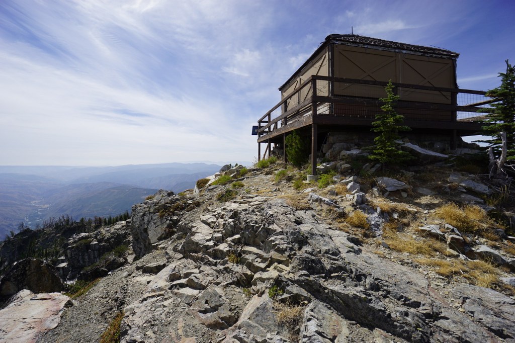
The final half mile gains little elevation. Tyee Ridge lookout sits out on a balustrade of rocks overlooking Eastern Washington’s tapestry of treed and grassy hillsides. Sit and stay a while and reflect upon what it is that brings you to this little slice of heaven.
 Trailhead


