

Begin at the official trailhead, the Goat Mountain trail. Day hikers, backpackers and scramblers alike frequent this trail for its many uses. The trail picks up on the west end of the trailhead and wastes no time in its ascent. Enjoy lush greenery on a well-groomed tread, climbing roughly 1,700 feet in just about 2 miles, until breaking open onto the south side of Goat Mountain ridge.
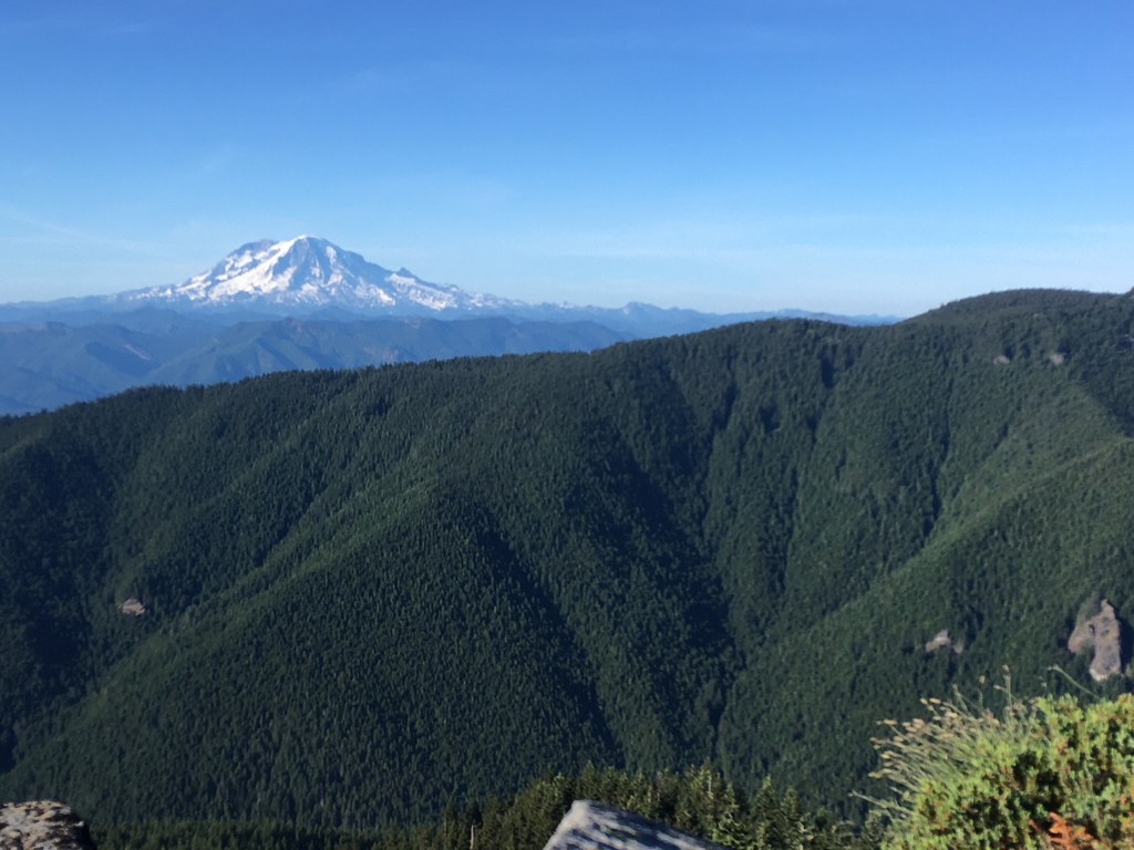
Here, the trail begins to level as you traverse through a beautiful set of adjoining meadows. Incredible views of the Green River Valley, Mount St. Helens, Mount Hood and Mount Adams are the focal point of this section. Continue on across the ridge for about another 1.5 miles, where you descend to the north side, greeted by a striking view north to Mount Rainier. Soon after, reach the base of this trail’s namesake on a hairpin turn. The west and east peaks of Goat Mountain tower above you. Experienced scramblers travel here to attempt the very steep and chaotic scree.
Following the trail for another mile, pass entry points over to Deadman’s Lake. This is a rather large, shallow and beautiful lake with ample camp sites and excellent beach access. Despite its reputation for a heavy amount of bugs, it is a popular destination for an overnight. (If in need of water to filter, note that this and, eventually, Vanson Lake are your only reliable options.) But your aim is further up the trail.
And up you will go, continuing on the rolling Goat Mountain trail for another 620 feet of ascent over 2.5 miles to a signed four-way junction. Here, the Goat Creek, Vanson Lake and Vanson Peak trails meet, granting hikers a few options. To the left, descend one mile with 500 feet of elevation loss to Vanson Lake. To the right, descend down a series of switchbacks following the Goat Creek trail, arriving at the cavernous Cathedral Falls at the 4.5-mile mark.
For Vanson Peak, press on straightaway along the southern approach to the summit. Climbing another half mile with 300 feet of gain, note to stay to the right at an intersecting trail two-thirds of the way up. Soon reach a clearing worthy of a fire lookout and soak in the expansive views: northeast to Mount Rainier, southeast to Mount Adams and more immediately northwest to Riffe Lake.
Extending your Hike
You can reach Vanson Lake directly from the summit for a camping option. To do this, return to the intersecting trail you passed on the way up. This is the northern approach to the summit on the Vanson Peak trail. Descend here one mile to a junction with Vanson Ridge and Goat Mountain trails. Turn left onto Goat Mountain trail and follow for a half-mile to a signed junction for Vanson Lake trail. Turn right here to descend a quarter-mile to the lake, for a total of 1.7 miles and 900 feet of elevation loss.
For a longer one-way loop, follow the unsigned Vanson Ridge trail from the aforementioned junction. From the junction, turn right onto Vanson Ridge trail and gradually descend, losing 1,730 feet of elevation over 3.3 miles and arrive to a signed junction with the Green River trail. Turn left here onto the Green River trail. Enjoy a beautiful, lush and rehabilitated forest for 7.7 miles while earning another 1,040 feet of gain, returning to the Goat Mountain trailhead.

 Trailhead


