Trails for everyone, forever

Home Go Hiking Hiking Guide Western Rim National Recreation Trail - Warnock Corrals to Grassy Knoll

Alert: On Oct. 1 the federal government began a partial shutdown that will impact National Parks, National Wildlife Refuges and U.S. Forest Service lands in Washington. Here's the latest information we have for hikers and campers


Western Rim National Recreation Trail - Warnock Corrals to Grassy Knoll

Southwest Washington > Columbia River Gorge - OR
45.4822, -116.6497 Map & Directions
Length
7.4 miles, roundtrip
Elevation Gain
770 feet
Highest Point
6,742 feet
Calculated Difficulty About Calculated Difficulty
Moderate
Wide open views from the trail. Photo by Austin Smith. Full-size image
Saved to My Backpack

This short stretch of a much longer trail is open to all users, horse, hiker, 4WD… Don’t let this put you off, though — everyone here has the same goal to see some amazing country. Continue reading

Rating
0.00 out of 5

(0 votes) Log in to rate

Hiking Western Rim National Recreation Trail - Warnock Corrals to Grassy Knoll

Riding high above Hells Canyon and the Snake River this is truly rustic country. This National Recreation Trail traverses atop Summit Ridge, winding its way south to north through the Hells Canyon National Scenic Area. Some of this longer trail is through national wilderness land, and some of it is through unprotected national forest land.

Starting to hike from the Warnock Corrals trailhead is a good choice for several reasons. Primarily, this is the northernmost driving point for casual drivers. There are restrooms here, a decent amount of camping, fresh flowing water, other trails to hike and spectacular views. 

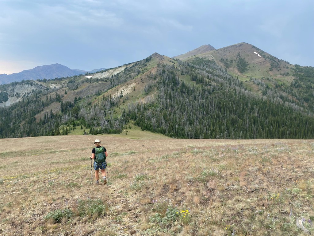
From Warnock Corrals, walk the 4WD road past a spring on the left and through a signed gate announcing 4WD terrain. Shortly thereafter, a non-motorized trail forks off to the right. Follow this trail directly along the rim overlooking Temperance Creek. In a mile or more, this trail rejoins the 4WD track and continues northward along the ridge. At 3.3 miles, a signed fork goes off right onto a grassy Knoll. In 1941-42, a fire lookout camp existed here. 

All along this route, you have the sense of being high and in the wilderness. There are numerous flowers as well as areas of recovering forest fire. There are trails (#1745 and #1745B) that appear on maps to create a loop to get back to Warnock Corral. As of August 2024 ,this connection was not feasible. Expect big skies, wildflowers and dry conditions. 

Hike Description Written by
Austin Smith, WTA Correspondent

Western Rim National Recreation Trail - Warnock Corrals to Grassy Knoll

Map & Directions

Trailhead
Co-ordinates: 45.4822, -116.6497 Open in Google Maps

Before You Go

See weather forecast

WTA Pro Tip: Save a copy of our directions before you leave! App-based driving directions aren't always accurate and data connections may be unreliable as you drive to the trailhead.

Getting There

From Enterprise, Oregon, travel south 6 miles on Highway 82 towards Joseph. In Joseph, turn left on Highway 350 and go 30 miles to Imnaha, Oregon. In Imnaha, travel about 26 miles on Forest Road 2640 (Hat Point Road) to the Warnock Corrals trailhead.

Please note that FR 2640 is a very steep, winding narrow gravel/dirt road. Low-clearance vehicles, RVs and vehicles pulling trailers are advised to use caution on the lower sections of this road. The road can also be slippery when wet or frozen, and is not recommended for trailers in the late fall and winter.

More Hike Details

Trailhead

Southwest Washington > Columbia River Gorge - OR

Western Rim National Recreation (#1774)

Wallowa-Whitman National Forest

You can improve or add to this guidebook entry!

Western Rim National Recreation Trail - Warnock Corrals to Grassy Knoll

1 Trip Report

Hiked here recently?

Submit a trip report!
 
Trip Reports