Trip Report
Pilot Ridge, Blue Lake High & North Fork Sauk River — Wednesday, Aug. 24, 2005
 North Cascades > Mountain Loop Highway
Well I did the North Fork Sauk Loop to White Pass and down Pilot Ridge. I had been to White Pass 5 or 6 times before and really wanted to make this loop trip. There is a lot of easy hiking on this loop.
The first 5 miles takes you through the old growth forest very gradually to Mackinaw Shelter. From here the trail switchbacks and takes you 4 miles up 3000 feet to the PCT between White Pass and Red Pass. Here there are signs telling you DETOUR, because of the bridges that are out. A few people asked me if you can still get to Red Pass and the answer is yes. Also if you don't then you have made a mistake because it is very excellent and only 1.3 miles 500 feet gained.
I chose to keep going and I knew the trail ahead was the easiest. It drops elevation for 6 miles to Indian Pass, but it drops it at such a slow pace that you almost think you are walking level the whole way. I actually saw tire tracks between Reflection Pond and Kid Pond! Someone had a Bicycle way up there. At Indian Pass there are detour signs. This is where the Crest trail now takes you down Indian Creek and over to Buck Creek Pass.
My route was taking me up Kodak Peak and I still had some steam in me so I kept going. 1.5 miles and 500 feet is the only other up the first day. Now on the other side I was going to find the first site possible since it was getting late. There is a very nice spot just on the North side of the Little Wenatchee River junction. 15.5 miles the first day 3500 feet gained. This campsite is directly in the middle of this loop.
The next morning I headed towards Dishpan Gap and it was an easy mile. The trail to the Blue lakes leaves the PCT here. It is 3 miles and very level for the first mile. Then there is a fork in the road that says Blue Lake high route not maintained for stock. I chose to take the high route which I beleive is a shortcut in mileage. Though it did take me nearly straight up 500 feet and straight down 500 feet right to upper Blue Lake. I would reccomend this for people not staying at the Blue Lakes because I would not have seen the upper lake at all had I not gone this way. And it really wasn't that hard of climb.
Just below Upper Blue Lake is the Pilot Ridge junction and from here the trail takes you, again very easily and gradually, up 500 feet. Once you reach the top of your climb you junction with Johnson Mountain Trail and then drop 100 feet. Now you hike flat for at least 2 miles and then up a little down a little for 1 or 2 more. Now you leave the meadows that you entered way back at the Blue Lakes and drop nearly straight down for half mile or so in the woods. The trail levels out and then goes straight back up for another half mile or so still in the woods and a little annoying to me. Though it does bring you out at the ridgetop for one last meadow the length of a football feild.
Now the trail heads down to the North Fork Sauk River. Sometimes the trail is nicely switchbacked and sometimes it drops you straight down. It is a 3000 foot drop none the less. Once at the North Fork Sauk, you need to cross on a series of logs. This crossing is fairly easy. Just on the other side is the North Fork Sauk Trail and a short, easy 2 miles back to the car.
I would say this to someone wanting to do the loop and trying to figure out which direction to go. If you go to White Pass first, you will be climbing an open hill that can be hot, but there is a lot to view. If you climb Pilot Ridge first, it is cooler, though very boring in the trees. I was very glad I hadn't hiked up the Pilot Ridge hill.
There were Blueberries all along this loop in the high country. I saw one deer, grouse, and only 6 other hikers. Looking back at the hike I don't really think I ever left the meadows from Half way up Sauk trail all the way to the end of Pilot Ridge. Now that is great!
Also the graded the Mountain Loop dirt road portion and the North Fork Sauk Road.
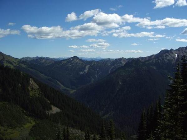
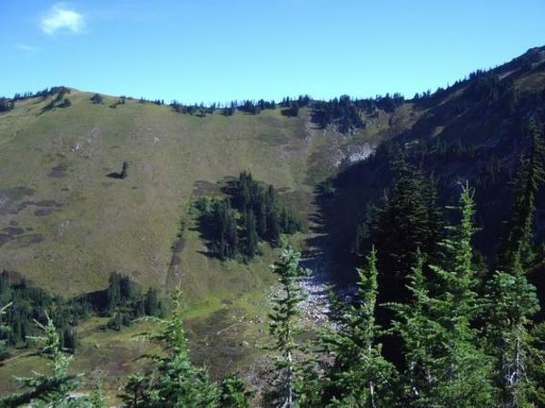
First picture is just before the Crest Trail on the N. Fork Sauk Trail looking South. Kodak Peak is in the middle of the photo. Second picture is taken from the Johnson Mountain junction at the start of pilot ridge looking across at the trail on the side of the hill.
Comments