

View one of the best examples of a recessional-cataract canyon. Potholes Coulee caught the attention of J Harlen Bretz in the early 20th century, which led to his “outrageous hypothesis” of Ice Age flooding.
Ancient Lakes, like nearby Dusty Lake, is a haven for backpackers in the spring and early summer. There are several ways to get into the area, all described below.
Upper trailhead (Judith Pool Trail)
From the parking area at the gate, drive or walk 0.2 mile down Quincy Lakes Road to a parking area on the right near a grove of cottonwood trees and an old metal sign marked “Ancient Lakes Trail”.
Follow the trail behind the sign through the sagebrush, flat at first, then contouring the side of a hill. At 0.5 miles, pass the tailings of a small diatomite and opalized chert mine. In another 0.25 miles, the trail drops down to lovely Judith Pool.
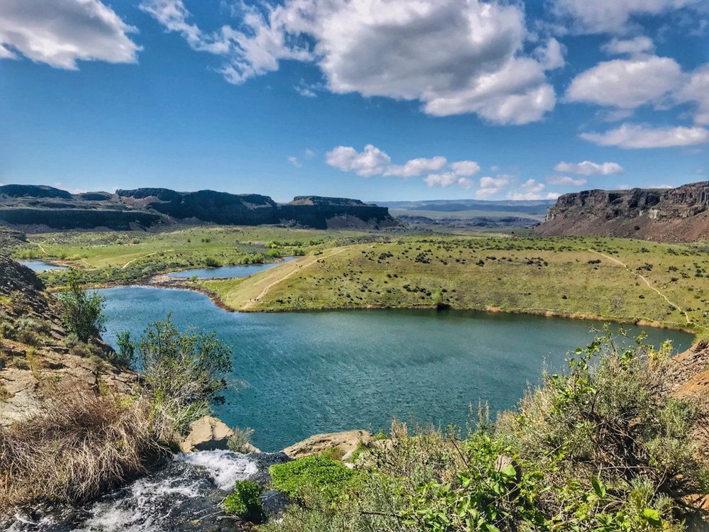
You can follow the route around to where it drops steeply down the upper cataract beside the waterfall coming out of Judith Pool. Once at the bottom, the trail flattens out where a side coulee comes in from the south and makes its way beside the outlet stream through a tall stand of common reeds to the brink of the middle cataract and a second waterfall dropping 160 feet into the Ancient Lakes Basin. From here, a steep trail descends the talus slope beside the waterfall into the Basin.
Once on the coulee floor, you can follow the numerous trails or just walk cross country as you explore the area around the lakes.
Upper Ancient Lakes Trail
From the parking area at the gate, walk 1.3 miles down Quincy Lakes Road to a parking area and outhouses on the right across from the west end of Burke Lake. (From January 1 to September 30, the gate is open and you can drive to the second parking area.)
Find the unsigned trail behind the outhouses heading northwest and follow it across flood-scoured scabland 0.7 mile to the brink of the upper cataract of Potholes Coulee. From here, descend a gully to the next lower bench and a fork in the trail.
The left fork takes you up to a notch in the Potholes Coulee Rib with a spectacular view down to Dusty Lake. You can also follow this trail west along the bench to another 0.5 mile to another notch in the rib with expansive views of both the Dusty & Ancient Lakes Basins.
The right fork of the trail descends the middle cataract to the coulee floor 1.5 miles from the trailhead. Once on the coulee floor, you can again follow the numerous trails or just walk cross country as you explore around the lakes.
BONUS: You can connect the Judith Pool Trail and the Upper Ancient Lakes Trail for a loop hike.
Lower Ancient Lakes trailhead
From the south end of the parking area follow the old 2-track along Babcock Bench 0.6 miles to a trail junction. Take the left fork and follow it up the coulee 1.5 miles to Ancient Lakes.
Note: there a couple of old 2-tracks as well as game trails that go up the coulee. Any one of them will get you to Ancient Lakes. On your return you can vary your route back up the coulee or just retrace your steps.
WTA Pro Tip: While there is water along this route, the water in the lakes is runoff from the plateau above and has not been tested. Drink at your own risk and always be sure to filter water before drinking. Better yet, plan to carry in all the water you'll need for the duration of your stay at Ancient Lakes.
 Trailhead


