

This hike along Baker Lake is a busy, popular trail in summer. It is a nice off season walk though, and is perfect on a crisp, clear winter day. With the leaves off the trees, views that aren't possible in summer emerge; the surrounding peaks and the mossy green silhouettes of the leafless maple trees cover the hillside. A bonus any time of year are the many creeks, quaint bridges, large old-growth trees and of course, Mount Baker as the main attraction.
The hike from the northern trailhead starts alongside the Baker River on a wide dirt path. Look ahead for a long suspension bridge over the river on your right. In a half mile the trail splits. Straight ahead is the trail up the river; a worthy river wander for another day.
Take the right trail and have fun crossing the suspension bridge. The child in all of us should get a little thrill as the bridge bounces with our steps! If the weather is cooperating, you will be able to see some of the nearby snow-capped peaks. Once across, the path heads over an old river channel and crosses Blum creek on the first of many wooden bridges. Climb a little as your path takes you between mossy boulders. Look for spaces in between them, and ponder what small creature would make the caves a winter home.
Cross another wooden bridge, and you see the river spreading out. Switchback up a short steep section and you will come to Hidden Creek. Just before crossing, there is a very large, recently downed tree. From the jagged stump, with your eyes follow the trunk downhill, you can see it broken in several places. Ponder for a minute, the power of nature that brought such a giant down.
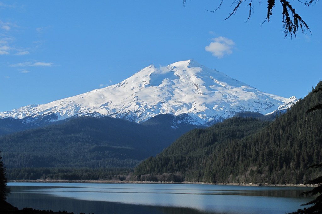
Hidden Creek is anything but hidden. It is a noisy and wide creek, the white water splashing among the mossy rocks and fallen branches. Here is another cool bridge! This one, built with a long zig zag shape,is also fun to cross, although it must have presented a challenge for the trail crews that engineered it. As you hike above the shoreline, the tip of Mount Baker should come into view above the hillside across the lake. Actually Baker Lake is a reservoir, made when the river was dammed, not the prettiest of lakes when the water is drawn down. In the summer, it is popular with boaters, fishermen, and swimmers.
Look instead as you hike along the trail, at the beautiful woods, with the green moss hanging off the maple trees and the old man’s beard hanging from the fir and hemlock. Enjoy the little streams and more wooden bridges. Remember the newly downed tree seen earlier? Compare that to the old mossy stumps, growing shelf fungus on their sides, the fallen trunks now nurse logs for growing hemlock seedlings. There are some big trees on this trail. Give them a hug, and wonder what it will take to knock them over and start a new cycle. In the spring, look for yellow violets and trillium here also.
Come to a wide, unbridged stream, it is shallow and easily crossed on a few well placed rocks. You will see more of Baker, both mountain and lake. It may be tempting here to make your way down to the shore for lunch. Hold off, a better spot awaits you on the other side of the small peninsula you can now see. Head through a small clearing in the trees, here are salmonberry plants growing, and when the magenta flowers open, you may find yourself nose to beak with a Rufus hummingbird.
Come to a signed intersection at 4.2 miles. The Baker Lake trail continues straight ahead and crosses Noisy Creek. The left fork heads up alongside Noisy Creek and the right fork leads to Noisy Creek campground. A good place for lunch, there are picnic tables, fire pits and tent sites, plus a backcountry toilet and a metal bear box. Stroll down to the beach for some great views of Mount Baker and maybe the tip of Mount Shuksan. Once lunch is eaten, take the trail up Noisy Creek. You don’t have to go far to see ‘Big Doug.’ This tree has got to be one of the biggest Douglas firs in the Cascades! You will recognize it by the huge gnarled old trunk. Turn around when you are ready to head back to your car, or continue along the main trail as far as you are able to go in a day.
WTA Pro Tip: This trail continues all the way along the east side of the lake, 14.5 miles one way. If you can arrange transportation, try a hike through. There are many trails to explore in the Baker Lake area, car camp at one of the campgrounds along the Baker Lake road and explore them all.
It's also possible to hike this trail from the southern trailhead. Located near the Anderson Creek Sno-Park, the route parallels Baker Lake, staying high on the slope and within the trees. In spring, wildflowers bloom alongside the trail.
At 1.8 miles a spur trail on your left leads to the Anderson Point Campground. This is a nice sidetrip or turn-around, since it takes you down to the lake. The best views, however, are found if you continue to the Maple Grove Campground at 3.8 miles.

 Trailhead


