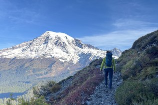
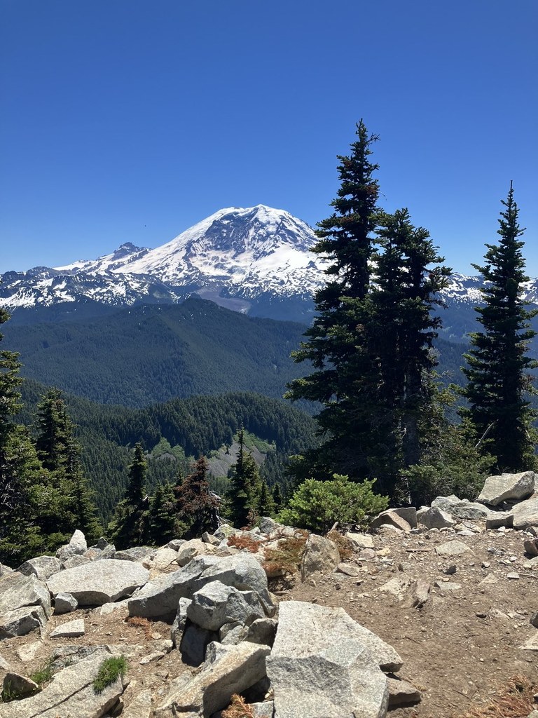
BearheadRecent Trip Reports
Hiked here recently?
Submit a trip report!
There are
31
trip reports for this hike.
See all trip reports for this hike.
Day hike
Features:
Wildflowers blooming
Expand report text
Hide report text
Read full report
with photos
i enjoy reading others reports on wta's website. after reading about bearhead mountain and summit la...
i enjoy reading others reports on wta's website. after reading about bearhead mountain and summit lake this summer i decided i had to do it. it had been on my wish list years ago and i was happy to read about it. i gathered up my hiking buddies and offered to drive my jeep patriot to the trailhead after reading about the nasty approach road. the road was as described but the jeep handled it comfortably. it was supposed to be the coolest day of the week, but it was warm at the trailhead. the forest provided shade and a cool breeze. once at the twin lake junction we decided to do bearhead mountain first then summit lake on the return. we traversed the forested hillside to a much traveled spur trail obviously to the top and the old lookout site. the continuation of the trail to carbon river was overgrown. as we ascended this spur the meadows opened up revealing the wildflower show in earnest. we switchbacked steadily to the lookout site and a fabulous view of mt rainier. since a friendly family had actually pitched a tent on the site to watch the sunset and sunrise we moved along a ridge top trail to another view point for lunch. by this time of the day it was getting pretty warm so we were glad to be back in the shade of the forest and the cool breeze. upon reaching the twin lake junction, we decided we would save summit lake for the fall. we opted to take a much needed swim in the lake which was very refreshing indeed. note: the trail had been cleared of blowdowns mentioned in earlier reports, thanks to wta trial crew? and no bugs to speak of.
Bearhead, Carbon Trail, Summit Lake
— Aug 10, 2012
— trailmarker
Day hike
Features:
Wildflowers blooming
Issues:
Blowdowns | Overgrown
Expand report text
Hide report text
Read full report
I hiked the trail to Bearhead Mountain after returning from Summit Lake, so I began the trip a...
I hiked the trail to Bearhead Mountain after returning from Summit Lake, so I began the trip at the Twin lake trail junction. When you're starting at Summit Lake trailhead #1177,walk a mile to the intersection and turn right. From here on the trail is not very good-narrow with numerous blowdowns and some slump outs.The path climbs and contours along the side of a ridge, finally arriving at a junction with Bearhead trail #1179.1 It really looks like a switchback, partly because Carbon Trail #1179 is so overgrown. In any event, make a hard left and begin climbing the ridge.
Now the good stuff starts. The way is steep, but the views of valley and meadows below a rocky ridge are excellent, and soon wildflowers are all around you. (Go soon though!) The view from the top of Bearshead is fantastic, with Rainier filling the sky. Turn round and you can see Summit Lake nestled in its basin. So, Summit Lake or Bearshead Mountain? For solitude, I think Bearshead is probably the better choice. It's more of a workout too. But, I found Summit Lake and the panoramas from the ridge above more rewarding. I think it may get really crowded on weekends though, because there are few trails so easy and yet so beautiful. Day hike
Features:
Wildflowers blooming
Issues:
Blowdowns
Expand report text
Hide report text
Read full report
with photos
Janet joined me for a trip to the area just northwest of Mt. Rainier. I first visited Bearhead Mount...
Janet joined me for a trip to the area just northwest of Mt. Rainier. I first visited Bearhead Mountain and Summit Lake on a very hot day in 2010. Reading back over my report from that day, I could have just cut and pasted it here. Almost the same weather, flowers, and number of other hikers. Instead, I will go ahead and describe this trip. It was supposed to be the hottest day of the year. It was. We met in Bellevue at 6:15 am and headed south. Down the Carbon River Road until just before the National Park boundary then across the bridge and on to the end at the 4300' trailhead. Even at 8:00 am the lot was nearly half full. A WTA work party was there to work on the trail.
The route begins in an old clear cut. The trail is very deeply rutted at first. On our way down we saw where the workers had filled in chunks of the ruts making for a much easier to hike trail. Soon the route enters older forest and the trail improves markedly. The route enters the Clearwater Wilderness and continues to climb at a gentle rate. The junction for the trail to Bearhead Mountain is at Twin Lake after about a mile. I recalled flowers here and it was the same as in 2010. Avalanche lilies, shooting stars, and marsh marigolds primarily. Avalanche lilies continued most of the way to the summit as either flowers or seed pods. It was comfortably warm when we started and became continuously warmer. The route traverses across the side of Bearhead and is mostly in the forest. That made it much cooler. There are a number of short open meadows and they all have blooming wildflowers. Lots of color from tiger lilies, columbine, lupine, and others. There were 7 or 8 trees down on the traverse. Several were big enough to cause us to inch our way underneath. Most were no problem. We finally reached the far ridge. A trail continues along the ridge but our route made a sharp left turn and began to ascend the ridge. The way goes in and out of forest and the wildflowers become much more numerous. Though many flowers are finishing down low the flower show is closer to peaking higher up. Soon we began to see the magenta Indian paintbrush seen mostly at Mt. Rainier. Fields of magenta paintbrush and white avalanche lilies. Throw in lots of yellows and whites and the color show was outstanding. The western anemone have already turned to their shaggy head stage. One group passed us as we slowed way down to enjoy the colors. In the open it was now much hotter so the shade that was available was much appreciated. The trail pops out on the summit ridge and a left turn and short climb brought us to the summit. The larger group that passed us was there so we headed a short way over to a rocky viewpoint. Lots of benchmarks there. I posted photos on my 2010 report so no need to take more. We could see out to Summit Lake. No snow apparent. As the day grew much hotter we did not look forward to dropping below the lake and then having to climb back up to it. There was no snow on the trail coming up but there is still snow on and just across the ridge top. Plenty to melt for water for a few more weeks at least. The ridge top has some excellent displays of avalanche lilies and magenta paintbrush. What I have not mentioned is the fantastic view of Mt. Rainier so close by. It grew hazy later in the day but was nice and clear in the morning light. We could also see far out to Mt. Baker, Glacier Peak, and Mt. Stuart. It was buggy at the old lookout site on the summit but not bad anywhere else all day. As two years earlier I it was soon time to check out the ridge of the summit ridge. A bootpath continues through patches of wildflowers along the ridge. Farther along we reached the other groups and turned around. We reached the summit at about 10:30 and started down just after 11:30. The flower show near the top was amazing and we went through it just as slowly while hiking down. I definitely stocked up with a year's supply of magenta paintbrush photos. One open spot on the ridge was extremely hot but we were soon back in forest once again. Two and a half miles later we were back at Summit Lake. Although neither of us handle heat well, Janet and I chose to climb up to Summit Lake. I expected to see a lot more people on that trail and so we did. Still, it was never crowded. The trail to the lake is in forest until just before the lake. This coincided with the best avalanche lily fields of the day. They were as thick as blades of grass. We passed the meadow and headed down to the lake. There is a big pond right before the lake. More flowers on the drop to Summit Lake. At the lake we found several groups of hikers. It is a big lake and we found a spot along the shore. The water was nice and cool and a cool breeze was blowing. That minimized any bug problem and provided much appreciated a moderation of the heat. For the next hour we either relaxed in the shade or photographed more avalanche lily meadows. We reached the lake at about 2:00 pm and stayed until almost 4:00 pm. It was a slow paced relaxing day with lots of laying around. Just the ticket when it is approaching 90 degrees. We had one small climb up from the lake then it was all a gentle descent back to the car. As mentioned we were impressed with the work done to fill in the rutted trail near the bottom. Back at the trailhead at around 5:00 pm we found 36 cars. Lots of cars though we did not see many people all day. We were hoping to get in some easy miles with wildflowers and some cooling at a high mountain lake. Check on each and every one. For the day we hiked about 10 miles with 2500' of elevation gain. Most of the gain was done in the cooler morning. Most of the afternoon was in dark forest or in the shade at the lake. It was much more comfortable than roasting in the city. Although it is already August the flower show was great. Better than I was expecting. With all this heat the flowers will not last many more weeks. Great views from the summit of Bearhead too. The hike to Summit Lake is awfully short but when combined with Bearhead Mountain it makes for a great day of hiking. I have posted 54 annotated photos on my website located at: http://www.hikingnorthwest.com. Go to "Trips - 2012" on the left margin. Day hike
Features:
Wildflowers blooming
Issues:
Blowdowns
Expand report text
Hide report text
Read full report
with photos
Nice weather. What to do? Plan an overnight. Make a call into a friend. Friend points out that it's ...
Nice weather. What to do? Plan an overnight. Make a call into a friend. Friend points out that it's going to be hot, dang HOT. Hmmm...overnight plans morph into plans for two easy-ish day trips.
Jim and I headed down towards Rainier early Saturday morning. Temps were expected to be in the 80's so we wanted an early start. Leaving the SE8th P&R on the east side we drove 405S>167S>410>165S...then where the road forks with the right branch heading up to Mowich Lk, we went left towards Fairfax (Carbon River Rd). The route then had us make a left onto FS 7810 (Cayada Ck Rd) and we followed it to the end, the TH, elevation ~4400'. The road is in OK shape, a bit washboarded and potholed in sections. But my regular clearance car made it to the TH. We were at the TH early and the lot was nearly full. There was a BCRT from WTA working to log out the trail up to summit lake. NOTE: There are about 8 logs down across the trail up to Bearhead. Only one was a real pain (requiring crawling under the log) the rest are big enough to cause diversions but no real difficulty. The trail up to Summit Lk is clear. The trail starts out in forest then there is about a 1/2 mile section of rough, cobbled, rutted trail through an old clear cut. The WTA BCRT was filling the ruts and repairing the trail. Thanks guyz! After that first 1/2 mile the trail goes into old forest, crossing into the Clearwater Wilderness. At about 1 mile (4800') the trail reaches Twin Lk. Jim and I headed left up to Bearhead wanting to get the harder part of the trip out of the way early. From the junction, the trail does a long traverse along the west side of Bearhead and at about 2.5 miles in (~5350') from the TH reaches another older trail junction. There was a faint trail that continued right. We thought maybe it was an old social trail that goes to a campsite or overlook. After getting home, the map shows a trail that continues on to Hurricane Gap and then down Clearwater Ck. Looks like an interesting diversion. Jim and I instead headed left, north and up the ridge. At about 3.2 miles from the TH the trail hits the top and a short hike left took us to the old lookout site. Just off the LO site to the west were a pile of rocks with 3 benchmarks. Interesting. Here for me was a quick lunch and then we dropped down that first bit to the junction but continues going a couple of bumps to the east following a good boot path. Lots and lots of flowers out. Then it was time to head down. We retraced our route back to the junction at Twin Lk. Looking to make it a decent mileage/elevation gain day we then headed up to Summit Lk which was about 1.6 miles and 900' gain (from Twin Lk junction). It was a nice visit to the lake. Lots of people dispersed about. Some camping. Some up for just the afternoon. It's surprisingly a gorgeous lake considering the easy access. We dozed around, time for photos, a short nap, dunk of the sore feet in the cool lake water, chatting with other hikers. Finally, it was late enough to head down (Jim looking to avoid Seafair traffic on the bridges) so we packed out stuff up and out we went. Full Flickr photoset here: http://www.flickr.com/[…]/ Stats for the day: 10.5 miles, 2792' gain (round trip) Notes: bugs - not a problem, logs down (see above), no water from the Twin Lks junction to Bearhead Mtn. Day hike
Features:
Wildflowers blooming
Issues:
Blowdowns | Water on trail | Snow on trail
Expand report text
Hide report text
Read full report
with photos
Hiked a Summit Lake/Bearhead Mountain double feature. Trails were generally in good condition, thou...
Hiked a Summit Lake/Bearhead Mountain double feature. Trails were generally in good condition, though we encountered some difficult blowdowns on the way up Bearhead. The trails are generally snow-free, with the exception of some of the minor trails around the Summit Lake basin. Bugs, though present, were minimal.
There were beautiful wildflowers on both trails. Lots of lilies on the way to Summit Lake. Lots more flowers on the way to Bearhead - lupine, paintbrush, and even blooming heather. I was particularly glad for the wildflowers on the latter - Rainier had clouded up by the time I summited but the flowers alone made that hike worth it! |
|
Document Actions
- Email this page
- Print this
- Share


