You are here: Home Find a Hike Hiking Guide Buck Creek Pass

Buck Creek Pass

 
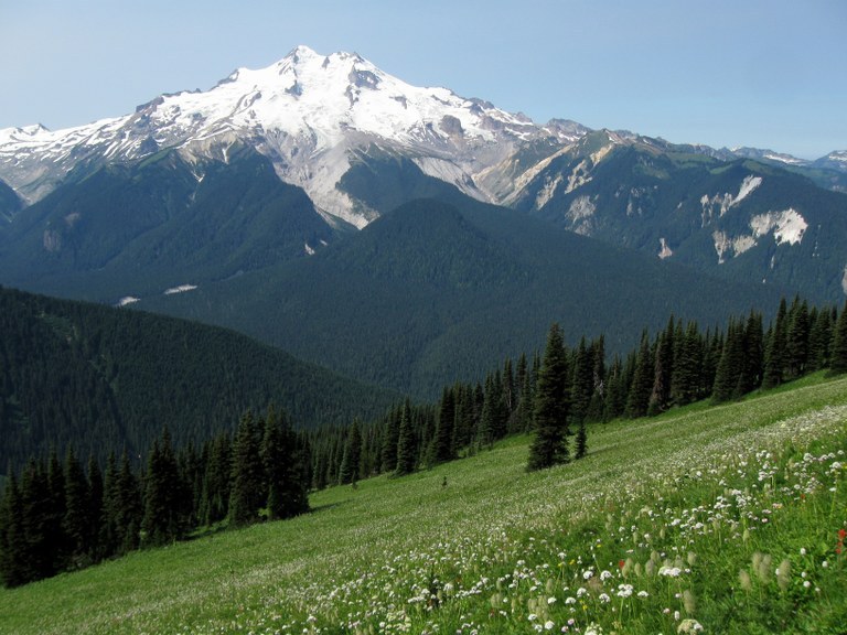
Glacier Peak Wilderness, northwest of Lake Wenatchee. You can barely see Glacier Peak from the westside of the Cascades. Not so from the Buck Creek Trail - where it looms over you like a white monolith. Add to that fields of late summer flowers and a pleasant afternoon breeze and you may be close to rapture.
Improve or add to this guidebook entry

Recent Trip Reports

Hiked here recently? Submit a trip report!
There are 53 trip reports for this hike. See all trip reports for this hike.
Buck Creek Pass — Aug 13, 2011 — Dave Schulldt
Multi-night backpack
Features: Wildflowers blooming
Issues: Snow on trail | Bugs
Expand report text Hide report text
Week long results. Cleared trail of blowdowns, did some brushing and tread work. Youth crew brushed lower part the week...
Week long results.
Cleared trail of blowdowns, did some brushing and tread work. Youth crew brushed lower part the week before. Flowers are in bloom. A few snow patches so we couldn't clean everything up. Show should be gone by next weekend. Flies at times. Very tame marmots at the pass. No berries.
Pics
http://gallery.me.com/dave.schuldt#100445
Read full report
Buck Creek Pass — Aug 06, 2011 — Constant Motion
Multi-night backpack
Issues: Snow on trail | Bugs
Expand report text Hide report text
Awesome weather greeted us for this trip. There was wind--and, admittedly, it was pretty strong at times (mostly while we...
Awesome weather greeted us for this trip. There was wind--and, admittedly, it was pretty strong at times (mostly while we were trying to sleep) and one day was cold enough to send all of us to our tents by 7:30pm but other than that the weather was great. The trail is clear of downed trees (now) and mostly passable. There are a few patches of snow that we were able to hike across but I wouldn't take a horse across them. They are roughly 6ish miles from the trailhead so a pack animal can go quite a ways. Saw a bear from our campsite--far enough away to be enjoyable without feeling threatened. Marmots were loud when we got too close. Flowers are just starting to bloom. I didn't see any ripe berries--hopefully the flowers and berries will be ready in a few weeks.
Read full report
Buck Creek Pass — Jul 22, 2011 — waterhog
Multi-night backpack
Features: Wildflowers blooming
Issues: Blowdowns | Snow on trail
Expand report text Hide report text
Tough hike into Buck Creek Pass. There were the usual downed trees and intermitten snow at about 4800 ft. Solid...
Tough hike into Buck Creek Pass. There were the usual downed trees and intermitten snow at about 4800 ft. Solid snow cover at the pass. However, there are two large avalanches covering the trail.
The first, about 6.5 miles in at an elevation of about 4000 ft, came off of Mt Cleator, crossed the creek and made it up the south slope several hundred feet.
The second, about 8.5 miles in at an elevation of about 5300 ft, came off of the ridge east of Fortress Mountain.
Talked to some Forest Service crew members on the way out. They are working on opening the approuch to the first avalanche, along with help from a volunteer crew from Washington Tails. The lower avalanche may melt out by the end of the summer. If we don't see warmer weather, the upper avalanche won't likely melt out this year.
We didn't have much difficulty traversing the debris field, but be careful as it melts out further. Pack stock is out of the question, and may be for the rest of the year.
Read full report
Buck Creek Pass, High Pass — Aug 14, 2010 — Cascade Liberation Organization
Multi-night backpack
Features: Wildflowers blooming
Issues: Bugs | No water source
Expand report text Hide report text
South of Buck Creek Pass on High Pass 1562.2 are world-class mountain views and vast subalpine meadows, wildflowers peaking NOW. If...
South of Buck Creek Pass on High Pass 1562.2 are world-class mountain views and vast subalpine meadows, wildflowers peaking NOW.
If you go to Buck Creek Pass, at a bare minimum make time to hike south at least as far as the first pass south of Liberty Cap. It sounds like walking through a beehive. Make sure you have plenty of memory; you won't be putting your camera away. From certain angles, you can see a white or purple dusting on distant meadows: valerian and lupine. This is a late flower year I think.
Get water at the spring at the pass; the ridge walk is pretty dry.
South of Liberty Cap, the trail shifts to the east side and you get the Buck Creek view. There are a couple of spots along this slope that look impassable to horses. E of Pt 7276 ("Rally Cap"?)is a short snow tongue arguably ice-axe terrain if hard. The little cirque NW of and below this point has a warren of visible trails, possibly old sheep trails.
Lots of snow at High Pass. In the heat of a hot day, while snow was soft, I saw one person cross it without anything, and two people cross it with poles. I'd get my ice ax out for it, esp. if it was cold and hard in the morning.
Mt. Cleator is a 7630' marmot path walk-up, only about 500' above the trail. Don't miss it. Gwynnie claims 2nd ascent by a tricolored Pembroke Welsh corgi on a Sunday without supplemental oxygen.
Give the Buck Pass spring the respect an important spring deserves. Keep your dog away from it. It's the last running water you'll see until you get to Cleator/High Pass. Many depend on it.
Hot. The flies in Buck Creek are serious, competent professionals dedicated to their work. Be prepared or you won't enjoy this. I seldom use DEET but I went through 1/4 bottle on this trip. Helps to soak your shirt and hat with water. They thin out shortly below the pass. It is worth it.
Buck Creek Trail is in excellent shape. The massive logouts in the avvy chutes will make you want to join a trail work party. The forest shows massive insect damage in the lower part of the valley, obvious from Mt. Cleator summit. This place is going to burn very hot someday.
Bear season starts Aug. 1, and there are many deer hunters here during High Hunt in late Sept. Check the hunting season.

Your gaze up the upper Suiattle valley will be richer if you've read C.E. Rusk's "Tales of a Western Mountaineer". In the early 1900's, Rusk and A.L. Cool hobbled their horses near Buck Pass, crossed the Suiattle, and headed upriver with 2 blankets, a gun, and little else; they shot a goat for food and made the 2nd ascent of Glacier Peak. And I thought I was a hiker.

If you know who A.H. Sylvester was -- he named many of the places on your maps -- this was one of his favorite areas, for the same reason we've been here 5 times.
http://en.wikipedia.org/wiki/Albert_Hale_Sylvester

Just walking the dog.
Read full report with photos
Buck Creek Pass, Suiattle Pass, Cloudy Pass to Holden — Jul 26, 2010 — Lee Altier
Multi-night backpack
Features: Wildflowers blooming
Issues: Bugs
Expand report text Hide report text
My 13-year-old son and I left early on July 26 from Trinity toward Buck Creek Pass. Unlike reports from...
My 13-year-old son and I left early on July 26 from Trinity toward Buck Creek Pass. Unlike reports from a year ago, the trail is in wonderful condition. The route through the tree blow-down is all cleared. We ran into a WTA trail crew (thanks volunteers!) at about six miles. We reached the pass (9.6 miles) at about 4 PM. Contrary to the reports that we received from rangers warning us about lots of snow at the pass, there was hardly any to be seen.

Since there were several camps of people already there, we hiked the short, steep mile further down to a small campsite by Small Creek feeling weary after what seemed like a long warm-up day.

The next day's hike of 8.5 miles or so to Suiattle Pass and on to Cloudy Pass was exhilarating with views west to Glacier Peak. Seemed much easier than the day before. We dropped down beyond Cloudy Pass to a campsite area with a view to Lower Lyman Lake below. The camp was in the midst of a marmot village. The marmots were very active and uninhibited by our presence. I am not sure who was more entertained, us or the marmots. The mosquitoes were out in dense swarms. Our lemon eucalyptus oil repellent was only marginally effective.

The next day we had a short hike of about 5.5 miles to Hart Lake. Met both US Forest Service personnel and NW Youth Corps members working on trail maintenance. No wonder the trail is in such great shape! We set up camp in the site on the west end of Hart Lake and enjoyed the afternoon relaxing and swimming. Although the black flies were numerous, they were much less intense than the mosquitoes the night before.

We left early on the fourth day and covered the 4.5 miles gentle walk down to Holden Village, by 11 AM on July 29, just in time for lunch!

Read full report
Buck Creek Pass Cascade Liberation Organization.jpg
Views from the Buck Creek Pass area. Photo by Cascade Liberation Organization.
WTA worked here!
2010, 2011
Location
Buck Creek Pass (#1513)
Central Cascades -- Stevens Pass - East
Okanogan and Wenatchee National Forests, Lake Wenatchee Ranger Station
Features
Wildflowers/Meadows
Mountain views
Wildlife
Ridges/passes
User info
Northwest Forest Pass required

Improve or add to this guidebook entry

Map it
Red Marker Buck Creek Pass
48.0770691 -120.8578772
  • Youth Vacations 2011
  • Volunteer Vacations 2011
  • Volunteer Vacations 2010
(48.0771, -120.8579) Open in new window
Document Actions
  • Email this page
  • Print this
  • Share
Log in


Forgot your login name or password?
New user?


Email Newsletter

Get Trail News each month hiking tips, trail ideas, action alerts.

Connect with us

Facebook_icon2 twitter_icon RSS_icon

Featured Member
Footer
powered by Plone | site by Groundwire and served with clean energy