You are here: Home Find a Hike Hiking Guide Snowgrass - Cispus Basin - Nannie Ridge Loop

Snowgrass - Cispus Basin - Nannie Ridge Loop

What's better than hiking to Snowgrass Flats and back? Hiking to Snowgrass Flats, then heading east to Cispus Basin and completing a loop on the Nannie Ridge Trail. Along the way, experience a broad expanse of meadow blooms with a lovely waterfall and the Goat Rocks looming overhead and Mount Adams close enough to touch to the south.

We offer a clockwise loop here, but it is just a beautiful the other way too. From Snowgrass trailhead (~4700' elevation) hike the first 2 miles through forest, mostly gradual uphill, to a bridge over Goat Creek, then a bit steeper to the intersection with bypass trail 97 at 4 miles, 5800' and Snowgrass Flats.

Go left to find a spot at the Alpine Camp near the Snowgrass meadows. But more exalted terrain awaits you if you take a right at the junction on the Bypass Trail (97) and hook up with the PCT. Drop your pack here and explore about for awhile before you continue east to the lovely expanse of Cispus Basin. This area boasts two incredible view camps with a fraction of the people you would find at Snowgrass.

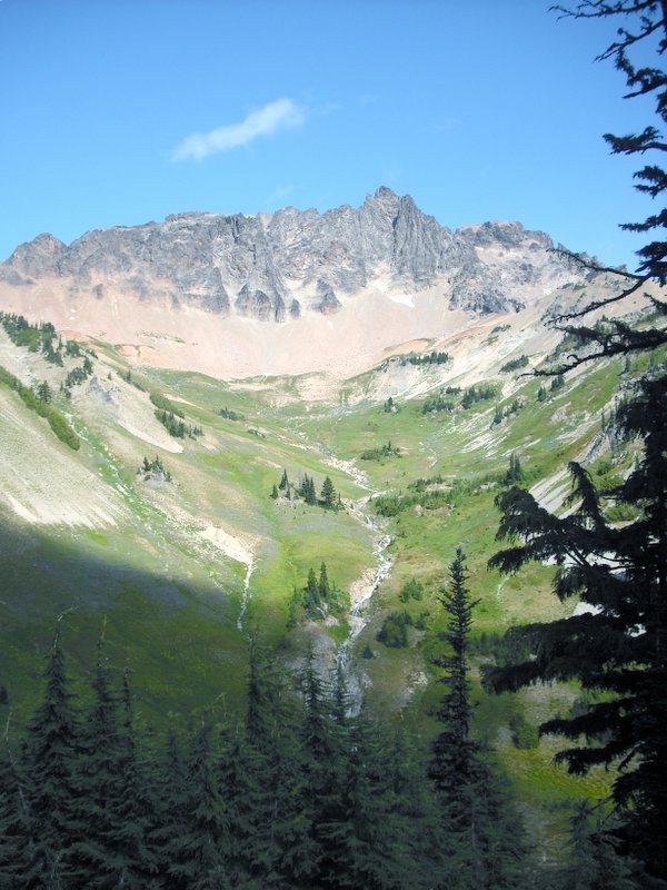
The trail circles left and down into the basin with Gilbert Peak and the Goat Rocks massif just ahead and Mount Adams close enough to touch to the south. Lupine, paintbrush, alpine daisies and lots of low-bush blueberries abound. Pass a 20-foot waterfall (scramble up the rocks to camps just above) and another creek crossing (more camps hidden in the trees just above) before starting up the rocky switchbacks to Cispus Pass. The trail climbs just 300 feet more to the pass, steadily opening up views of the forested ridges of the Nannie Creek and Walupt Lake basins.

Cispus Pass is a small saddle at 6400', with views east to the headwaters of the Klickitat River. The PCT continues to beckon southward, clinging to the side of the hill for another half-mile until passing back over to the west side of the ridge and dropping steeply to the intersection of the PCT with the Nannie Ridge trail 98 at 1.9 miles from the pass. Pretty little alpine Sheep Lake at 5800' is just past the junction, with a few more nice camps nearby. Follow Nannie Ridge with just a few ups and downs for about 2.5 miles to a junction and a nice little scramble route to the top of Nannie Peak, or another two miles with a final steep downhill to the Walupt Lake trailhead at 4000', 6.4 miles from Cispus Pass.

Follow the trail along the road exiting the campground to just past the Guard Station, then go right (north) on Trail 121(A) and 7A as it returns to your car at Chambers Lake. The approximate distance from Walupt Lake Campground to Chambers Lake is six miles. If you can arrange a shuttle, you can avoid this last unexciting bit.

Nice campgrounds at Walupt Lake and at Chambers Lake near the two trailheads.
Driving Directions:

Drive highway 12 south 2.5 miles from Packwood and turn east on Johnson Creek Road, #21. Drive 15.7 miles to road 2150, signed Chambers Lake, and from there follow the signs approx 2 more miles to the Snowgrass Flats trailhead (NOT Berry Patch TH which will take you up Goat Ridge).

Or, to start at the other end, continue east on Johnson Creek Rd past the Chambers Lake turnoff to road 2160 toward Walupt Lake; turn left and travel 3.2 miles to the Walupt Lake CG and the Nannie Ridge trailhead.

Improve or add to this guidebook entry

Recent Trip Reports

Hiked here recently? Submit a trip report!
There are 20 trip reports for this hike. See all trip reports for this hike.
Snowgrass - Cispus Basin - Nannie Ridge Loop — Sep 21, 2012 — Matt
Multi-night backpack
Features: Wildflowers blooming
Issues: Bridge out
Expand report text Hide report text
I did this loop with my daughter and it was a fantastic hike. The description on this site is good ...
I did this loop with my daughter and it was a fantastic hike. The description on this site is good but would benefit from more information about the last section of the trail. First, trail 7A begins a full 1 1/2 miles from the Walupt Lake campground. Second, the guard station (if it still exists) is very hard to find and not a good landmark. The trail to ColrmamanWeedpatch and associated turnout across the road from 7A is a better landmark. Fourth, trail 7A is not very visibly signed so you really need to be looking out for it. And lastly, once you get on the trail, there are multiple trail junctions, marked only by small wooden signs attached to trees. Again, look closely for them.
Read full report
Snowgrass - Cispus Basin - Nannie Ridge Loop — Sep 07, 2012 — ILikeToHike
Multi-night backpack
Features: Wildflowers blooming
Expand report text Hide report text
This was a great backpacking trip. We did the 20 miles in 2 nights and 3 days. Although the parkin...
This was a great backpacking trip. We did the 20 miles in 2 nights and 3 days. Although the parking lot was packed, most people seemed to be doing a clockwise loop that included goat lake. We camped the first night past the Alpine camp, right on the cispus basin. It was beautiful! We camped the second night at Walupt lake, taking care to camp away from the car campers. All signage up until the 3rd day was clear. We saw some people but not many. Flowers blooming, plenty of small streams to pump water, and the hike was not terribly difficult. The third day we left Walupt lake on the road and found the trail to Walupt Creek. Signs say the bridge is out but we crossed it easily. Then in about a 1/4 mile we passed Nannie Creek, which looked more like a river. I thought I could tiptoe across but ended up with wet boots for the rest of the hike. Calf length gaitors would've been all I needed, but I left those at home. My hiking partner took off her shoes and crossed safely...concentrating when crossing the slippery rocks. It was hard to see the trail after the creek crossing, but we spotted a small cairn (rock pile) and we were able to find the trail again. We were on trail 7A and things were going smoothly until we came to a dirt road that dead ended where it met the trail (I don't see this road on the green trails map). On the other side of the road, there was a trail marker for 7A, but it was just thick bushes and we saw no trail. We went 30 yards on both sides of the marker, trying to find the trail with no luck. We bushwhacked a 1/4 mile in there, and we did find remnants of a trail that we would follow for 50 yards and then it disappeared. We found another remnant and the same thing happened. Finally we decided to bag the hike and go back to the road and hope for a car to hitch a ride with. We hiked northwest on the road for about a 1/4 mile and found 7A Klickitas River trail. Why there would be two 7A trails is a mystery. This trail took us back to our car at Snowgrass Flats. I talked to the Supervisor at the Ranger station and gave him this feedback. If they just changed the sign near the nonexistent 7A trail, letting hikers know to follow the road, it would've saved us a lot of stress. Still, we had a great hike. We swam in Walupt Lake, saw lots of birds and had a great time. It didn't get that cold at night, even at 6,000 feet.
Read full report
Snowgrass - Cispus Basin - Nannie Ridge Loop — Sep 03, 2012 — NC to WA Convert
Multi-night backpack
Features: Wildflowers blooming
Expand report text Hide report text
Ventured out to Goat Rocks over the labor day weekend, thinking we could escape the crowds. However...
Ventured out to Goat Rocks over the labor day weekend, thinking we could escape the crowds. However, lots of people made the long drive south and the parking lots were packed. Fortunately the Snowgrass basin is large enough to disperse everyone accordingly and we were still able to find some solitude.

The Goats were out in in force and the scenery is everything we thought it would be, a photographers paradise.
Read full report with photos
Goat Lake-Jordan Basin, Snowgrass - Cispus Basin - Nannie Ridge Loop — Sep 02, 2012 — seattlehiker
Overnight
Features: Wildflowers blooming
Issues: Snow on trail
Expand report text Hide report text
Couldn't make it out of the city for the entire weekend, so we decided to do a long overnight in the...
Couldn't make it out of the city for the entire weekend, so we decided to do a long overnight in the Goat Rocks Wilderness (almost exactly halfway time-wise from Seattle and Portland, for my Portland-dweller friend).

Left Seattle late Saturday night and camped at the Chambers Lake campground a quarter mile from the trailhead. No problems finding a campsite. Started from the Snowgrass trailhead, traveling counterclockwise up the loop to Goat Lake. We split off at the Bypass Junction toward Cispus Basin. We dropped our packs at the junction with the PCT and hiked up to Cispus Pass 30 pounds lighter. The basin and pass were beautiful, with abundant flowers and tremendous views of Old Snowy on the way back. Lots of people were out on the trail, everyone heading different directions and coming from different places.

Picked up our packs again and continued the slog up to Goat Lake. The first mile after the bypass is still in the trees, but after that the views get better and better. You pass through a number of idyllic meadows with wildflowers, tarns, streams, and wildlife. There were many, many lovely campsites along the way. Plenty for people to spread out and find some privacy.

Camped the night at Goat Lake overlooking Mt. Adams. The wind coming off the lake at night was chilly. Next time I might opt to camp closer to the Flats. But the view of Adams was spectacular, and worth the chill air. We saw a number of mountain goat herds up on the aptly named Goat Ridge.

The next morning we continued counter-clockwise toward Jordan Basin. We dropped our packs again at the Lily Basin Trail cutoff to hike the 1.2 miles up to Hawkeye Point. The Point is 1000 feet above Goat Lake. If you're hiking to the lake, I highly recommend taking a side trip to Hawkeye. It's not much extra effort, but you get spectacular 360 views of Rainier, Helens, Adams, and even Hood in the distance. There was one dicey snow patch on the way up to Hawkeye, but it was easily navigated around with a little extra effort. After Hawkeye, we made the slog back to the car. Jordan Basin was also quite beautiful, with one particularly choice camping spot.

A wonderful overnight! The only thing that could've made it better was more time.
Read full report with photos
Nannie Ridge-Sheep Lake, Nannie Peak, Snowgrass - Cispus Basin - Nannie Ridge Loop — Aug 26, 2012 — Susan Elderkin
Overnight
Features: Wildflowers blooming
Expand report text Hide report text
Lupine. If there was one word that summed up our hike to Cispus Basin, it is lupine. Great fields...
Lupine.

If there was one word that summed up our hike to Cispus Basin, it is lupine. Great fields of white lipped blue flowers that could be seen from a mile away. I've never seen such a display and wonder if any other place could top it. The lupine overshadowed the glorious orange paintbrush, the size of a child's fist. And the Seussian towhead baby seedpods, waiting for a paintbrush to turn them into mini Trufula trees. The flowers were without a doubt at their peak.

The hike wasn't bad either. We were fortunate to have two cars so that we could do it as a 15-mile one-way overnight from the Snowgrass Flat trailhead, over Cispus Pass to Sheep Lake, up along Nannie Ridge to Walupt Lake Campground. We put away the first 4 miles to the junction quickly, turning right on the Bypass trail - leaving most of the other hikers and Snowgrass Flat for another time. We passed a happy group of WTA volunteers, just off a week of improving the trail around Snowgrass and another group (whose name I couldn't quite make out on their hardhats) tackling mud on the Bypass trail.

At about 5.5 miles, we lunched on a rocky point (site of an excellent, albeit dry, camp) that provided a view of the entire Cispus Basin that we were to traverse. The going really got great here, with flowers, views and even a waterfall. It's wise to pick a campsite in the Basin (please don't camp on the meadows!), as the water dries up until Sheep Lake, many miles further on.

On day 2, we crossed over Cispus Pass. You can follow a way trail along the ridge line for more views. We scrambled down a 10 foot section of remaining snow, then stayed high above the headwaters of the Klickitat River to another pass a bit further on. We passed several groups of PCT thru hikers here, giddy because they were so close to finishing their months-long trek and because they were pleasantly surprised by the beauty and the weather.

Finally, we got a view of Mount Adams, hidden while we were in Cispus Basin (where you can see St. Helens only). The lupine continued as we descended to Sheep Lake, the scene of many good established camps. We filled our water bottles near where someone spent the night before - feet away from the lake, crushing the meadow plants. Please don't, people!

We headed up to Nannie Ridge, a nice hike but one that pales in comparison to Cispus Basin. At the ridge, we dropped our packs and took the trail to the top of Nannie Peak, where there's a peek-a-boo view of Rainier and an AMAZING view of Adams.

Our last leg took us to Walupt Lake, a long, dusty slog downhill. We had our hearts set on harvesting huckleberries. True enough, there were lots of huckleberry plants, but alas not a single ripe berry. In fact, not many green ones either. Why do these bushes not produce?

Walupt Lake provided a nice place to clean the volcanic ash and dust off our legs and cool off. Of note, the water spigots in the campground were wrapped in plastic.
Read full report with photos
DSCF0043-1.JPG
Cispus Basin with Gilbert Peak and the Goat Rocks Massif in the background
Location
Snowgrass Flats (#96), Bypass (#97), PCT (#2000), Nannie Ridge (#98), (#121(A)), (#7A)
South Cascades -- Goat Rocks
Gifford Pinchot National Forest, Cowlitz Creek Ranger District
Statistics
Roundtrip 19.6 miles
Elevation Gain 3000 ft
Highest Point 6400 ft
Features
Rivers
Lakes
Waterfalls
Fall foliage
Wildflowers/Meadows
Mountain views
Ridges/passes
Established campsites
User info
May encounter pack animals
Northwest Forest Pass required
Guidebooks & Maps
South Cascades
Green Trails Walupt Lake #335
Green Trails Blue Lake #334

Improve or add to this guidebook entry

Map it
Red MarkerSnowgrass - Cispus Basin - Nannie Ridge Loop
46.4586735198 -121.530761719
(46.4587, -121.5308) Open in new window
Document Actions
  • Email this page
  • Print this
  • Share
Get the Guidebooks

Mountaineers three booksSelect content from The Mountaineers Books' guidebooks is featured in this Hiking Guide. Sales of the books from this website help protect and maintain trails.

> Shop Now

More hikes » Hike of the Week
Red Top Lookout (Jun 13)

Red Top Lookout

Snoqualmie Pass

Whether you're camping near Cle Elum or just want a prime picnic location for a short Saturday hike, you'll only have to climb a mile on this steep, easy-to-follow trail to get stunning views from a fire lookout (and cool alpine outhouse). It can be great for kids, but keep them close on the exposed summit.

Get Trail News

Subscribe to our free email newsletter for hiking news, events, gear reviews and more.

link