

Cross Crystal Creek on a rustic log bridge and start up the trail. Be prepared for some switchbacks. The trail is good, despite a bit of steepness, a few roots, even a short section on very-weathered boardwalk. The route begins in shady sub-alpine forest, with only an occasional glimpse of Rainier through the trees.
After 1.3 miles and 1600 feet of elevation gain, come to a junction with the Crystal Peak Trail. The peak is a great viewpoint, but it's a steep 2.5 mile hike from the junction, with 1800 feet of elevation gain. So Crystal Peak might be a worthy destination for a different hike.
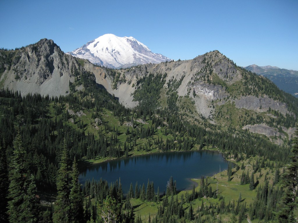
Climb a few more switchbacks and cross an old avalanche chute, less obvious in recent years, with its new growth. Soon, there is an opening through the trees and Mount Rainier comes into the fullest view you will have on this entire hike. It's a great photo-op, particularly in morning light. Farther up the trail, the mountain will disappear behind a shoulder of Crystal Peak, and if you hike on above Crystal Lake only the summit dome will reappear, not the entire mountain.
A mile past the Crystal Peak Trail junction, come to a signed T-junction. The left branch goes on to Crystal Lake, and the right branch to Lower Crystal Lake. If the lower lake is your goal, go for it. It's only 100 yards down to the designated camp area, which includes two sites plus a bear pole, and a few feet farther to the edge of Lower Crystal Lake. Even if your goal is the upper lake, you might want to take this 100-yard side trip. The lower lake is not visible from farther up the trail, so this will be your only chance to see it.
The lower lake is relatively small, with a dense growth of sedges around much of the shoreline. The lake is surrounded by small trees, and rocky peaks rise beyond the trees in the distance. It's a pleasant, peaceful spot to enjoy.
The trail continues on. The forest becomes more open and when in season, wildflowers bloom along the edges of the trail. Indian paintbrush, western anemone and lupine are common here, and you will find many others. After 0.7 miles from the T-junction, reach Crystal Lake itself. The designated camping area is off to the right, and offers several sites.
The upper lake is much larger than the lower lake, and it's in a dramatic setting in a basin walled by rugged peaks. Notice particularly Three Way Peak to the northeast. It has a small window through the rock formation, slightly to the right and a bit lower than the summit. Scan the peaks surrounding the lake for other interesting features.
You are only three miles from the trailhead so there's no need to hurry back. Take a leisurely walk around the shore of Crystal Lake and just relax and appreciate the beautiful setting. You might even find that you have company. It's not unusual to see mountain goats or elk in the vicinity.
Extend your hike
For many years there has been a trail that leaves Crystal Lake and climbs 600 feet in one mile, crossing the ridge east of the lake and meeting the Pacific Crest Trail (PCT) just north of Sourdough Gap. Signs at the ridge top mark the park boundary and alert hikers coming from the PCT about park camping regulations, but do not mention Crystal Lakes specifically. Some earlier maps and guide books omit this trail, but it is shown on the Green Trails Mount Rainier Map (269S) and on some other recent maps.
To locate the trail up to Sourdough Gap, follow the shoreline trail around the north side of Crystal Lake about 0.1 mile. Come to an obvious Y where the right fork continues on around the lake shore. The left fork is the trail you want. It heads slightly uphill toward Three Way Peak, then climbs more steeply toward the northeast before bending back south and reaching the ridge top east of Crystal Lake. In season many wildflowers bloom along the way, and there are great views looking back down on Crystal Lake, with the summit of Mount Rainier showing in the distance.
From the ridge top, the trail continues on 100 yards, dropping a few feet to meet the PCT at a switchback. Continue south on the PCT an additional 200 yards to reach Sourdough Gap. Enjoy great views south to Mount Adams, Mount St. Helens and other high points, and down to Sheep Lake 600 feet below. For most hikers, the gap will be a good turn-around point.
The PCT continues on, dropping down and passing Sheep Lake, then crossing Highway 410 at Chinook Pass, 2.4 miles from Sourdough Gap. This suggests the possibility of arranging a car shuffle and doing an interesting through-hike, beginning at Chinook Pass and ending at the Crystal Lakes trailhead, or vice-versa.

 Trailhead


