
To misquote a famous author, this hike can be "the best of trips or the worst of trips". Done in the right season, it has beautiful flowers, ripe berries, expansive views, great campsites, fishing, and swimming. Done in the wrong season, it has treacherous avalanche chute crossings, wet trail, no flowers, muddy campsites, and horrendous bugs.
The hike to Dewey Lake is very popular and in mid-season, the parking lot for the Pacific Crest Trail (PCT) fills in the morning. This lot is also the start for the hike to Sheep Lake/Sourdough Gap. If possible, a mid-week hike will improve the sense of solitude and the opportunity for a good campsite around one of the lakes.
While the trail can be accessed shortly after Chinook Pass opens in the spring, it is usually a snow trip until mid-June. In late June and early July, the trip can be a disappointment. The avalanche chutes on the north side of Naches Peak are the last to melt out and can pose a treacherous crossing for the unprepared. At the same time, the sign "Mosquito House" near the high point, describes what awaits hikers descending to the lake in this season.
By late July, the bugs have started to subside and the flower show is in full bloom. In mid-August, the berries have ripened and the lake has warmed enough for wading and swimming. In September, the fall colors are starting, and in late September the bugs are gone, the air is brisk, and the sound of elk bugling can be heard.
The southbound (PCT) is accessed via a short trail starting just south of the trailhead signboard at 5400 feet. At the junction with the PCT, this meadow is flower-filled in late July and the fragrance of the lupine can be almost overwhelming. This is a preview of what's to come in the next 1.5 miles.
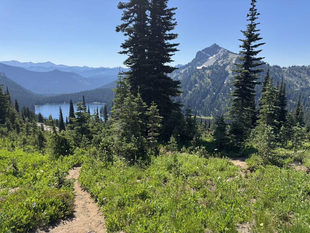
Turn left and follow the wide trail for 0.2 miles to the large trail bridge over Highway 410. Start the traverse around the north side of Naches Peak, entering the William O. Douglas Wilderness Area at 0.5 mile. It then crosses a few gullies, which are avalanche chutes in the winter & spring, before entering a basin with a small tarn. Informal trails take off to the tarn and viewpoints beyond it. The PCT continues its gradual climb to the local high point at 1.7 miles and 5900 feet. Dewey Lake is visible in the forested valley.
Continuing on the trail, the junction with the Naches Peak Loop Trail is reached, which is also a jurisdiction boundary. To the west is Mount Rainier National Park, which means no pets on the trail in that direction. For those wanting see Mount Rainier, continue on the Naches Loop Trail for 0.1 mile and climb 100 feet to the viewpoint. After enjoying the views, return to the junction and start the 700 foot descent to Dewey Lake.
The initial descent is on an eroded and rocky trail with water bar steps. At 2.2 miles from the trailhead, the trail enters the forest and the trail quality improves to provide a pleasant descent. At 2.9 miles and 5200 feet the lake basin is reached and a couple of unsigned trails.
The first trail (to the southwest, right) is 0.7 mile long and goes around the unnamed lake above Dewey Lake, passing two campsites before rejoining the PCT at the unnamed lake outlet crossing.
The second trail (to the northeast, left) leads to a campsite and then a small beach for wading/swimming in Dewey Lake. After the beach, it continues around the north side of the lake, passing a number of campsites and access points for lake, before reaching a junction with the Dewey Lake Trail at the east end of the lake. The eastern portion of this trail provides the only views of Mount Rainier from the lakeshore.
From the unsigned junctions at 2.9 miles, the PCT descends to cross the unnamed lake outlet and then continues around the southern side of Dewey Lake. There are a number of campsites and lake access points. Some even have small beaches for wading and swimming. Here is where most people turn around and head back to the trailhead.
Note: It is possible to go past Dewey Lake and reconnect with the road further on. 3.5 miles the PCT reaches a junction with the Dewey Lake Trail. To the left on the Dewey Lake Trail are a few more campsites, although not at the lake, and in 0.2 mile a junction with the trail around the north side of the lake. After the junction with the north side trail, the Dewey Lake Trail descends 1500 feet along the American River to a trailhead near Highway 410.
Dewey Lake

-
 Length
- 6.0 miles, roundtrip
-
 Elevation Gain
- 1,270 feet
-
 Highest Point
- 5,900 feet
9.3.25: The trail is closed until further notice due to the Wildcat Fire.
SR 410 (Chinook Pass) is closed between Crystal Mountain Boulevard (12 mi north of summit) and Morse Creek (5 mi east of summit) for the winter season.
Parking Pass/Entry Fee
Northwest Forest Pass
To misquote a famous author, this hike can be "the best of trips or the worst of trips". Done in the right season, it has beautiful flowers, ripe berries, expansive views, great campsites, fishing, and swimming. Done in the wrong season, it has treacherous avalanche chute crossings, wet trail, no flowers, muddy campsites, and horrendous bugs.
Continue reading
Hiking Dewey Lake

WTA worked here in 2007, 2006, 2001 and 2000!
Map & Directions
 Trailhead
Before You Go
9.3.25: The trail is closed until further notice due to the Wildcat Fire.
SR 410 (Chinook Pass) is closed between Crystal Mountain Boulevard (12 mi north of summit) and Morse Creek (5 mi east of summit) for the winter season.
Parking Pass/Entry Fee
Northwest Forest PassWTA Pro Tip: Save a copy of our directions before you leave! App-based driving directions aren't always accurate and data connections may be unreliable as you drive to the trailhead.


